METAR & TAF PAGT
PAGT does not publish a METAR.
Showing the nearest reporting station: PAOO (TOKSOOK BAY) · 12.1 NM away. Conditions at PAGT may differ.
METAR · PAOO
Observed 15:20Z
PAOO 281520Z AUTO 09012KT 10SM -RA SCT018 OVC036 09/07 A2998 RMK AO2 TSNO PNO $
- Wind
- 090° @ 12 kt
- Visibility
- 10 SM
- Temp / Dew
- 9°C / 7°C
- Altimeter
- 29.98 inHg
- Clouds
- OVC
- Density alt
- -786 ft
- Ceiling
- 3,600 ft AGL
- Rules
- VFR
Airport info & contacts
Manager on record, flight service, ARTCC, attendance schedule and pattern altitude — published by the FAA and refreshed every 28 days.
Location
- From city
- 1 NM N
- VFR sectional
- BETHEL
- ARTCC
- ZAN · ANCHORAGE
- NOTAM facility
- ENA (NOTAM-D)
Airport manager
- Name
- JOSEPH LARAUX
- Phone
- (907) 543-2498
- Address
- BOX 505, BETHEL AK 99559
Flight service · Hours
- FSS ENA
- KENAI907-283-72111-866-864-1737
- Attendance
- Unattended
Frequencies
Tap any row to copy the frequency to your clipboard.
Runways & pattern
Full pagePattern entry · RWY 03
LEFT TRAFFICRunway end performance
| End | TORA | TODA | ASDA | LDA | VGSI | Approach lights | Obstruction |
|---|---|---|---|---|---|---|---|
| 21 | — | — | — | — | — | — | 5', brush, 45' from thr, 70' R of cntrln, slope 15 |
Declared distances in feet. TORA = takeoff run available, TODA = takeoff distance, ASDA = accelerate-stop, LDA = landing distance.
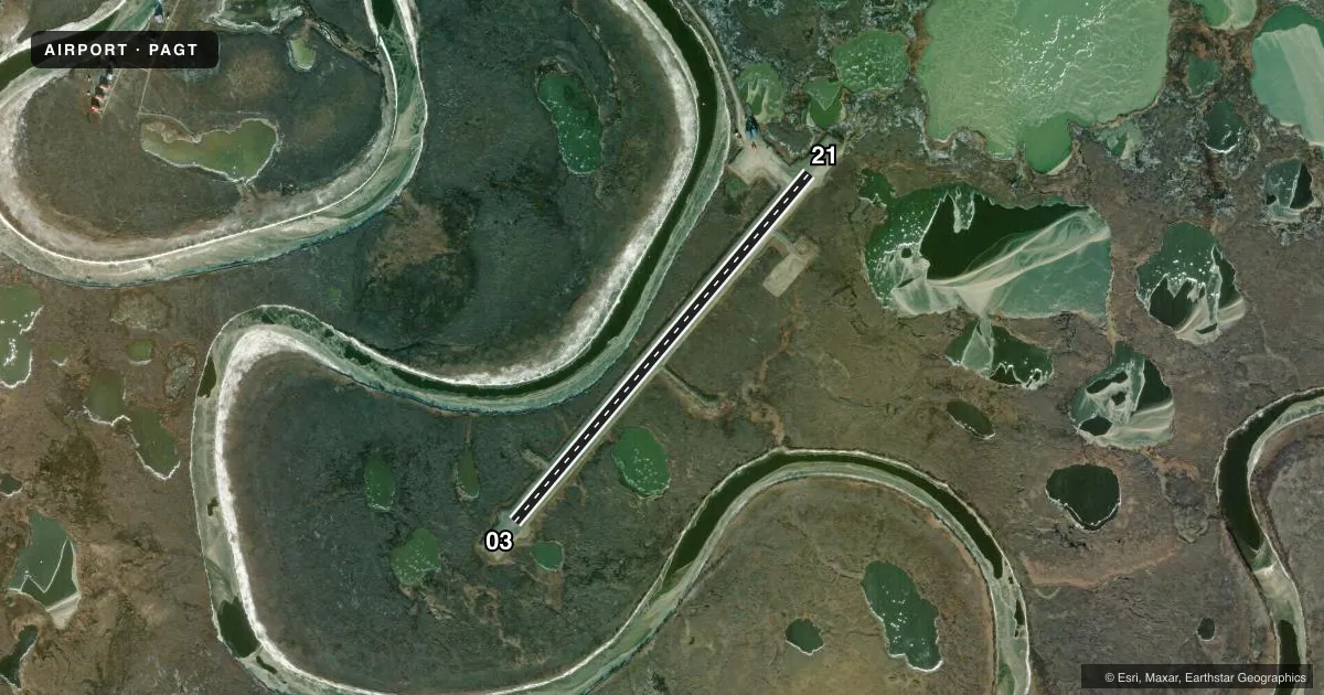
Airport sketch
Runways drawn to scale from FAA survey coordinates, rendered over satellite imagery. Not for navigation.
Approaches & charts
Services on the field
Fuel grades, oxygen, maintenance, ramp storage and lighting — as declared to the FAA by the airport operator.
Fuel & services
- Fuel
- Not available
- Oxygen (bottled)
- Not available
- Oxygen (bulk)
- Not available
- Airframe repair
- Not available
- Power plant repair
- Not available
Ramp & ground
- Transient storage
- Not published
- Landing fee
- No fee published
- Lighting schedule
- SEE RMK
- Beacon schedule
- SEE RMK
- Beacon
- White / Green (civil land)(WG)
- Wind indicator
- Lighted
- Segmented circle
- Yes
Fuel & FBOs
Cheapest 100LL and Jet A on the field and nearby. Always confirm with the FBO before taxi.
Airport notes
Surface conditions, obstructions, local procedures, lighting outages and other notes published with each FAA cycle.
General notes
- RY COND NOT MONITORED; RECOMMEND VISUAL INSPECTION PRIOR TO USING.
- BIRD ACTIVITY INVOF ARPT.
- RWY SURFACE IS SOFT GRAVEL, CAUTION SURFACE CAN BE VERY SOFT WHEN WET. LOOSE GRAVEL ALONG RWY EDGE CAN BE VERY SOFT.
Lighting notes
- ACTVT ROTG BCN - CTAF.
- ACTVT MIRL RWY 03/21 - CTAF.
Approach & departure obstructions
- 03RY 03/21 NSTD MKGS: RY MKD WITH REFLECTIVE CONES AND FLEXIBLE MARKERS.
Other notes
- 03/21DIPS IN RY SURFACE; IRREGULAR SURFACES FULL LENGTH.
VFR map & nearby airports
VFR sectional. Tap any ICAO chip to open that airport.
Key facts · PAGT
Answer card- ICAO
- PAGT
- Name
- NIGHTMUTE
- Location
- NIGHTMUTE, ALASKA
- Elevation
- 7.1 ft MSL
- Traffic pattern altitude
- 1,007.1 ft MSL (1,000 AGL)
- Control tower
- Non-towered (use CTAF)
- Total runways
- 1
- Longest runway
- 03/21 · 3,200 ft
- Published ILS approaches
- 0
- Published frequencies
- 1
- Magnetic variation
- 17°
- Current flight rules
- VFR
- Current wind
- 090° at 12 kt
- Favored runway now
- RWY 03
Nightmute Airport sits in Nightmute, Alaska at 7.1 ft MSL. It has one runway, 03/21, which is 3,200 ft long. There is no control tower. CTAF is 122.9. No ILS approaches are published here.
The pattern altitude is not published. Use the standard 1,000 ft AGL pattern unless local guidance says otherwise. The runway surface is soft gravel. The FAA remarks also call out dips and irregular surfaces along the full length of the runway. Loose gravel near the edge can be very soft. A visual inspection before landing is a good idea. Runway 03/21 is marked with reflective cones and flexible markers. Medium intensity runway lights and the rotating beacon are activated by CTAF.
There are no on-field FBOs listed in the facts. FBO options vary. Contact the airport operator directly before arrival, or call the field on CTAF for current FBO availability. Bird activity is also reported in the area, so keep a sharp scan on approach and departure. This is a low-elevation Alaska strip with a gravel surface, so plan for soft-field technique and check the current Chart Supplement for any updates before you go.