METAR & TAF POKA
Current METAR
Observed 04:56Z
POKA 280456Z AUTO 12014KT 10SM BKN015 BKN020 OVC070 09/06 A3002 RMK AO2 SLP170 T00940056 PNO $
- Wind
- 120° @ 14 kt
- Visibility
- 10 SM
- Temp / Dew
- 9°C / 6°C
- Altimeter
- 30.02 inHg
- Clouds
- OVC
- Density alt
- -767 ft
- Ceiling
- 1,500 ft AGL
- Rules
- MVFR
Airport info & contacts
Manager on record, flight service, ARTCC, attendance schedule and pattern altitude — published by the FAA and refreshed every 28 days.
Location
- From city
- 1 NM SW
- VFR sectional
- BETHEL
- ARTCC
- ZAN · ANCHORAGE
- NOTAM facility
- ENA (NOTAM-D)
Airport manager
- Name
- JOSEPH LARAUX
- Phone
- 907-543-2495
- Address
- PO BOX 505, BETHEL AK 99559
Flight service · Hours
- FSS ENA
- KENAI907-283-72111-866-864-1737
- Attendance
- Unattended
Frequencies
Tap any row to copy the frequency to your clipboard.
Runways & pattern
Full pagePattern entry · RWY 16
LEFT TRAFFICRunway end performance
| End | TORA | TODA | ASDA | LDA | VGSI | Approach lights | Obstruction |
|---|---|---|---|---|---|---|---|
| 34 | — | — | — | — | — | — | 50', hill, 1470' from thr, 420' R of cntrln, slope 29 |
Declared distances in feet. TORA = takeoff run available, TODA = takeoff distance, ASDA = accelerate-stop, LDA = landing distance.
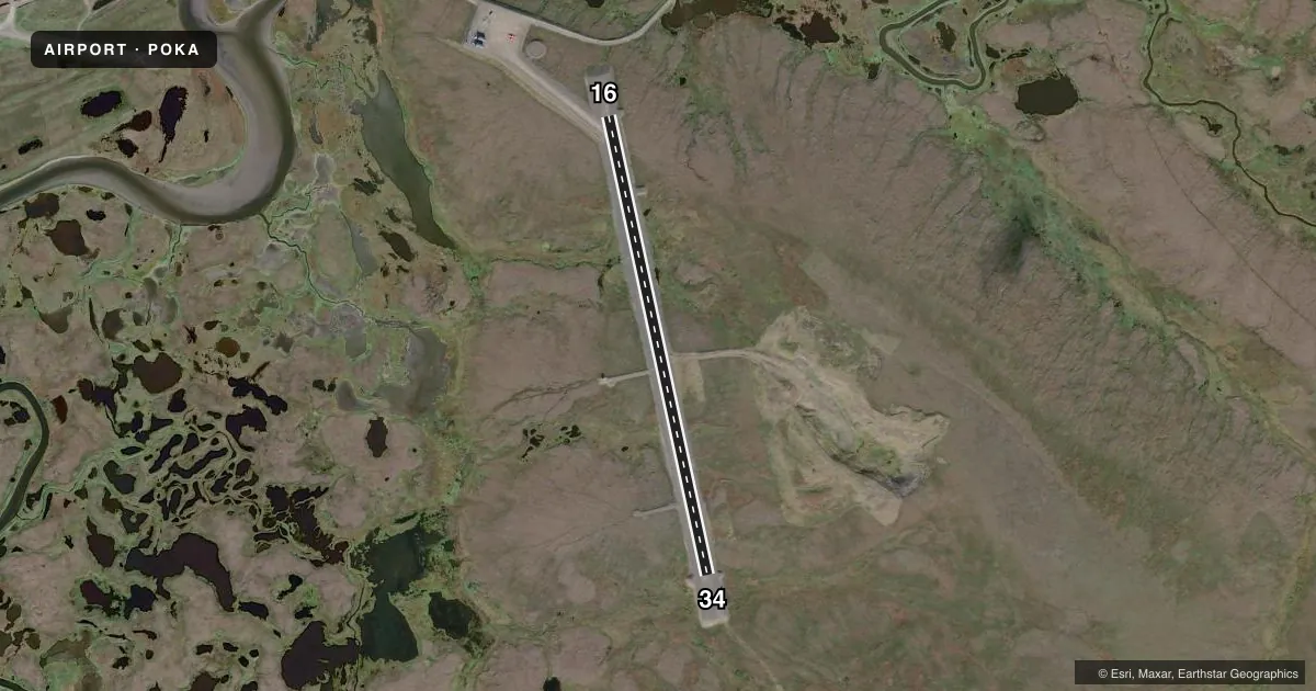
Airport sketch
Runways drawn to scale from FAA survey coordinates, rendered over satellite imagery. Not for navigation.
Approaches & charts
Services on the field
Fuel grades, oxygen, maintenance, ramp storage and lighting — as declared to the FAA by the airport operator.
Fuel & services
- Fuel
- Not available
Ramp & ground
- Transient storage
- Not published
- Landing fee
- No fee published
- Customs
- Not available
- Lighting schedule
- SS-SR
- Beacon schedule
- SS-SR
- Beacon
- White / Green (civil land)(WG)
- Wind indicator
- Lighted
- Segmented circle
- Yes
Fuel & FBOs
Cheapest 100LL and Jet A on the field and nearby. Always confirm with the FBO before taxi.
Airport notes
Surface conditions, obstructions, local procedures, lighting outages and other notes published with each FAA cycle.
General notes
- RWY COND UNMNT; RCMD VISUAL INSP BFR USE.
- BIRDS & WILDLIFE ON & INVOF ARPT.
Runway surface & condition
- 16/34HEAVES & DIPS FULL LEN.
VFR map & nearby airports
VFR sectional. Tap any ICAO chip to open that airport.
Key facts · POKA
Answer card- ICAO
- POKA
- Name
- TUNUNAK
- Location
- TUNUNAK, ALASKA
- Elevation
- 62.3 ft MSL
- Traffic pattern altitude
- 1,062.3 ft MSL (1,000 AGL)
- Control tower
- Non-towered (use CTAF)
- Total runways
- 1
- Longest runway
- 16/34 · 3,300 ft
- Published ILS approaches
- 0
- Published frequencies
- 1
- Magnetic variation
- 8°
- Current flight rules
- MVFR
- Current wind
- 120° at 14 kt
- Favored runway now
- RWY 16
Tununak Airport sits in Tununak, Alaska. The field elevation is 62.3 ft MSL. It has one runway. Runway 16/34 is 3,300 ft long and gravel. The runway headings are 168° and 348° magnetic. There is no control tower. CTAF is 122.9. No ILS approaches are published.
The pattern altitude is not published. Use the standard 1,000 ft AGL for light piston operations unless the current Chart Supplement says otherwise. That puts the pattern at about 1,062.3 ft MSL based on the listed field elevation. The airport has no on-field FBOs listed, so plan on local coordination before you go.
A first-time pilot should pay close attention to the runway notes. The Chart Supplement says runway condition is unmonitored, so a visual inspection before use is recommended. It also notes birds and wildlife in and near the airport. Runway 16/34 has heaves and dips along the full length. That matters on a gravel strip, especially if you are landing light or operating with a tailwind margin that is already tight. Check the current Chart Supplement for any other local remarks before departure.