METAR & TAF PAMY
Current METAR
Observed 07:56Z
PAMY 280756Z AUTO 17006KT 10SM OVC013 08/08 A2998 RMK AO2 RAB18E37 SLP150 P0000 T00830083
- Wind
- 170° @ 6 kt
- Visibility
- 10 SM
- Temp / Dew
- 8°C / 8°C
- Altimeter
- 29.98 inHg
- Clouds
- OVC
- Density alt
- -848 ft
- Ceiling
- 1,300 ft AGL
- Rules
- MVFR
Airport info & contacts
Manager on record, flight service, ARTCC, attendance schedule and pattern altitude — published by the FAA and refreshed every 28 days.
Location
- From city
- 3 NM W
- VFR sectional
- BETHEL
- ARTCC
- ZAN · ANCHORAGE
- NOTAM facility
- MYU (NOTAM-D)
Airport manager
- Name
- NICK NORWOOD
- Phone
- (907) 543-2498
- Address
- BOX 505, BETHEL AK 99559
Flight service · Hours
- FSS ENA
- KENAI907-283-72111-866-864-1737
- Attendance
- Unattended
Frequencies
Tap any row to copy the frequency to your clipboard.
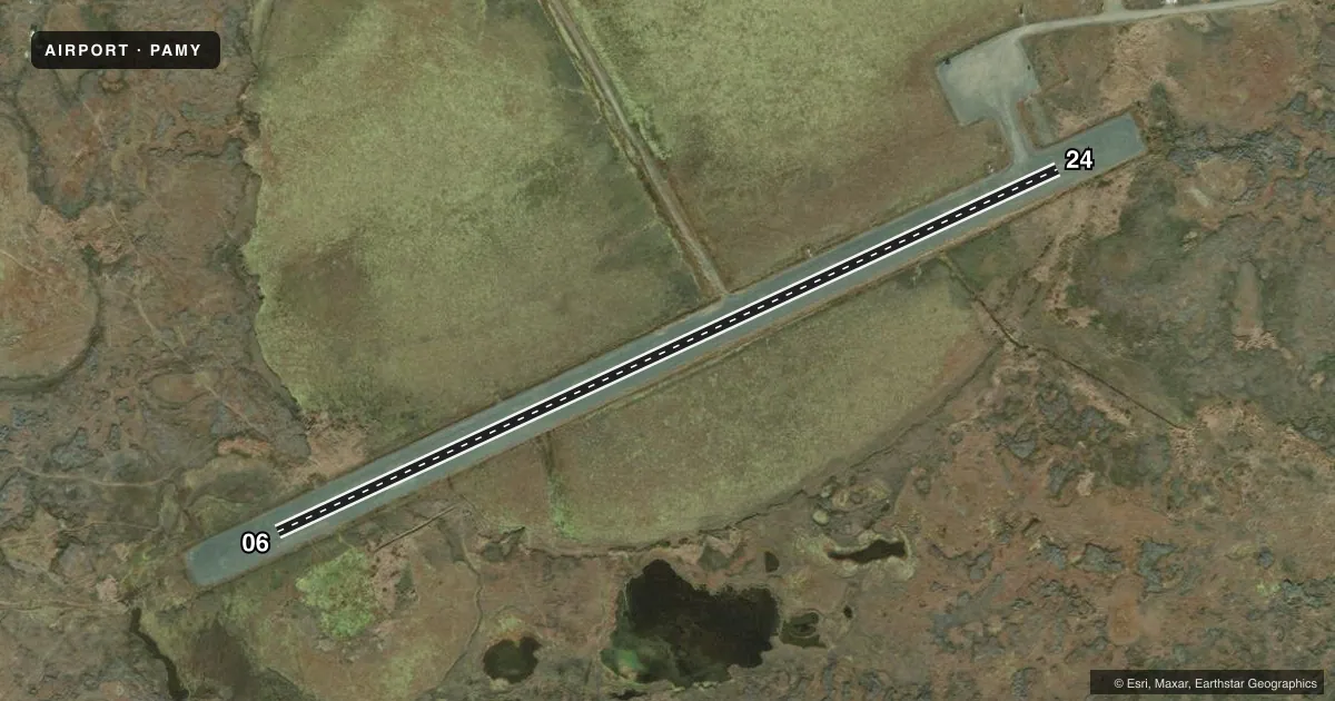
Runways & pattern
Full pagePattern entry · RWY 24
LEFT TRAFFICRunway end performance
| End | TORA | TODA | ASDA | LDA | VGSI | Approach lights | Obstruction |
|---|---|---|---|---|---|---|---|
| 06 | — | — | — | — | VASI 4-box left(3°) | — | 15', road, 65' R of cntrln, slope 0 |
| 24 | — | — | — | — | VASI 4-box right(3°) | — | 15', road, 65' R of cntrln, slope 0 |
Declared distances in feet. TORA = takeoff run available, TODA = takeoff distance, ASDA = accelerate-stop, LDA = landing distance.
Airport sketch
Runways drawn to scale from FAA survey coordinates, rendered over satellite imagery. Not for navigation.
Approaches & charts
Services on the field
Fuel grades, oxygen, maintenance, ramp storage and lighting — as declared to the FAA by the airport operator.
Fuel & services
- Fuel
- Not available
Ramp & ground
- Transient storage
- Not published
- Landing fee
- No fee published
- Customs
- Not available
- Lighting schedule
- SEE RMK
- Beacon schedule
- SS-SR
- Beacon
- White / Green (civil land)(WG)
- Wind indicator
- Lighted
- Segmented circle
- Yes
Fuel & FBOs
Cheapest 100LL and Jet A on the field and nearby. Always confirm with the FBO before taxi.
Airport notes
Surface conditions, obstructions, local procedures, lighting outages and other notes published with each FAA cycle.
General notes
- WILDLIFE ON RWY.
- RWY COND UNMNT; RCMD VISUAL INSP PRIOR TO USE.
- WX CAMERA AVBL ON INTERNET AT HTTPS://WEATHERCAMS.FAA.GOV
Lighting notes
- ACTVT VASI RWY 06 & 24; MIRL RWY 06/24 - CTAF.
Approach & departure obstructions
- 06REFLECTIVE CONES & THR PANELS.
- 24REFLECTIVE CONES & THR PANELS.
- 06CTLG OBSTN EXCEEDS 45 DEG SLOPE.
Other notes
- UNRELBL.
- 06/24SHALLOW RUTS WITH PONDING AFT RAIN.
VFR map & nearby airports
VFR sectional. Tap any ICAO chip to open that airport.
Key facts · PAMY
Answer card- ICAO
- PAMY
- Name
- MEKORYUK
- Location
- MEKORYUK, ALASKA
- Elevation
- 53.3 ft MSL
- Traffic pattern altitude
- 1,053.3 ft MSL (1,000 AGL)
- Control tower
- Non-towered (use CTAF)
- Total runways
- 1
- Longest runway
- 06/24 · 3,001 ft
- Published ILS approaches
- 0
- Published frequencies
- 1
- Magnetic variation
- 8°
- Current flight rules
- MVFR
- Current wind
- 170° at 6 kt
- Favored runway now
- RWY 24
Mekoryuk Airport sits in Mekoryuk, Alaska. Field elevation is 53.3 ft MSL. The airport has one runway, 06/24, which is 3,001 ft long and gravel. There is no control tower. CTAF is 122.9.
No ILS approaches are published here. Pattern altitude is not published, so use 1,000 ft AGL for light piston operations unless the current Chart Supplement says otherwise. The runway headings are magnetic. Runway 06 is 065° magnetic. Runway 24 is 245° magnetic.
This is a small Alaska field, so plan for local conditions rather than assuming a standard paved-airport setup. The Chart Supplement notes an obstruction near runway 06 that exceeds a 45 degree slope. It also notes shallow ruts and ponding after rain on 06/24. Wildlife is present on the runway. The runway condition is unmonitored, so a visual inspection before use is a good idea. Visual approach slope indicators are available for both ends. Medium intensity runway lights are controlled by CTAF. Runway 06 and runway 24 also have reflective cones and threshold panels.
No on-field FBOs are listed. Check with the airport operator or the current Chart Supplement before arrival if you need services.