METAR & TAF PAVA
Current METAR
Observed 14:03Z
PAVA 281403Z AUTO 00000KT 10SM BKN013 OVC019 08/08 A3001 RMK AO2 $
- Wind
- 000° @ 0 kt
- Visibility
- 10 SM
- Temp / Dew
- 8°C / 8°C
- Altimeter
- 30.01 inHg
- Clouds
- OVC
- Density alt
- -876 ft
- Ceiling
- 1,300 ft AGL
- Rules
- MVFR
Airport info & contacts
Manager on record, flight service, ARTCC, attendance schedule and pattern altitude — published by the FAA and refreshed every 28 days.
Location
- From city
- 1 NM N
- VFR sectional
- BETHEL
- ARTCC
- ZAN · ANCHORAGE
- NOTAM facility
- VAK (NOTAM-D)
Airport manager
- Name
- JOSEPH LARAUX
- Phone
- 907-543-2498
- Address
- 2016 AIRPORT ROAD, BETHEL AK 99559
Flight service · Hours
- FSS ENA
- KENAI907-283-72111-866-864-1737
- Attendance
- Unattended
Frequencies
Tap any row to copy the frequency to your clipboard.
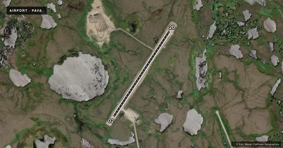
Runways & pattern
Full pagePattern entry · RWY 02
LEFT TRAFFICRunway end performance
| End | TORA | TODA | ASDA | LDA | VGSI | Approach lights | Obstruction |
|---|---|---|---|---|---|---|---|
| 02 | — | — | — | — | PAPI 4-box left(3°) | — | — |
| 20 | — | — | — | — | PAPI 4-box left(3°) | — | — |
Declared distances in feet. TORA = takeoff run available, TODA = takeoff distance, ASDA = accelerate-stop, LDA = landing distance.
Airport sketch
Runways drawn to scale from FAA survey coordinates, rendered over satellite imagery. Not for navigation.
Approaches & charts
Services on the field
Fuel grades, oxygen, maintenance, ramp storage and lighting — as declared to the FAA by the airport operator.
Fuel & services
- Fuel
- Not available
Ramp & ground
- Transient storage
- Not published
- Landing fee
- No fee published
- Customs
- Not available
- Lighting schedule
- SEE RMK
- Beacon schedule
- SEE RMK
- Beacon
- White(W)
- Wind indicator
- Lighted
- Segmented circle
- Yes
Fuel & FBOs
Cheapest 100LL and Jet A on the field and nearby. Always confirm with the FBO before taxi.
Airport notes
Surface conditions, obstructions, local procedures, lighting outages and other notes published with each FAA cycle.
General notes
- EXP XWINDS.
- RWY COND UNMNT; RCMND VISUAL INSP PRIOR TO USE.
- WX CAMERAS AVBL ON INTERNET AT HTTPS://WEATHERCAMS.FAA.GOV
- BIRDS ON & INVOF ARPT.
Lighting notes
- NSTD FLASHING.
- ACTVT - CTAF
- ACTVT MIRL RWY 02/20 - 122.8. ACTVT REIL RWY 02 & 20; PAPI RWY 02 & 20 - CTAF.
Runway surface & condition
- 02/20USED AS ROAD.
Other notes
- MANAGER907-543-2498
- 02/20FIRST 200 FT OF RWY 02 ROUGH.
VFR map & nearby airports
VFR sectional. Tap any ICAO chip to open that airport.
Key facts · PAVA
Answer card- ICAO
- PAVA
- Name
- CHEVAK
- Location
- CHEVAK, ALASKA
- Elevation
- 60.7 ft MSL
- Traffic pattern altitude
- 1,060.7 ft MSL (1,000 AGL)
- Control tower
- Non-towered (use CTAF)
- Total runways
- 1
- Longest runway
- 02/20 · 3,220 ft
- Published ILS approaches
- 0
- Published frequencies
- 2
- Magnetic variation
- 9°
- Current flight rules
- MVFR
- Current wind
- 000° at 0 kt
- Favored runway now
- –
Chevak Airport is in Chevak, Alaska. The field elevation is 60.7 ft MSL. It has one runway, 02/20, which is 3,220 ft long and gravel. There is no control tower. No ILS approaches are published here.
Pattern altitude is not published. Use the standard 1,000 ft AGL pattern for light piston operations unless the current Chart Supplement says otherwise. The airport sits in a place where crosswinds are expected. Runway 02/20 is used as a road. The first 200 ft of runway 02 is rough. Runway condition is unmonitored, so a visual check before use makes sense. Birds are reported on and near the airport.
Lighting is pilot-activated. Medium intensity runway lights for 02/20 are turned on with 122.8. The runway end identifier lights and PAPI on both ends are activated on CTAF. Beacon activation is also on CTAF. The beacon has nonstandard flashing. There are no on-field FBOs listed. Contact the airport manager at 907-543-2498 for current field details. For weather, FAA weather cameras are available online. A first-time arrival should plan for a gravel strip, keep an eye on crosswind limits and verify the runway surface before landing.