METAR & TAF PAMO
Current METAR
Observed 00:39Z
PAMO 280039Z AUTO 21005KT 10SM BKN028 OVC041 12/07 A2998 RMK AO2 $
- Wind
- 210° @ 5 kt
- Visibility
- 10 SM
- Temp / Dew
- 12°C / 7°C
- Altimeter
- 29.98 inHg
- Clouds
- OVC
- Density alt
- -14 ft
- Ceiling
- 2,800 ft AGL
- Rules
- MVFR
Airport info & contacts
Manager on record, flight service, ARTCC, attendance schedule and pattern altitude — published by the FAA and refreshed every 28 days.
Location
- From city
- 2 NM NE
- VFR sectional
- BETHEL
- ARTCC
- ZAN · ANCHORAGE
- NOTAM facility
- MOU (NOTAM-D)
Airport manager
- Name
- ERIK WEINGARTH
- Phone
- 907-438-2416
- Address
- PO BOX 135, ST MARY'S AK 99658
Flight service · Hours
- FSS ENA
- KENAI907-283-72111-866-864-1737
- Attendance
- Unattended
Frequencies
Tap any row to copy the frequency to your clipboard.
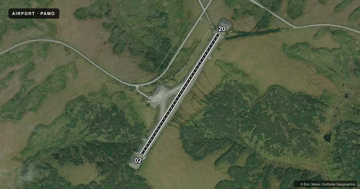
Runways & pattern
Full pagePattern entry · RWY 20
LEFT TRAFFICRunway end performance
| End | TORA | TODA | ASDA | LDA | VGSI | Approach lights | Obstruction |
|---|---|---|---|---|---|---|---|
| 02 | — | — | — | — | PAPI 4-box left(3°) | — | — |
| 20 | — | — | — | — | PAPI 4-box left(3°) | — | — |
Declared distances in feet. TORA = takeoff run available, TODA = takeoff distance, ASDA = accelerate-stop, LDA = landing distance.
Airport sketch
Runways drawn to scale from FAA survey coordinates, rendered over satellite imagery. Not for navigation.
Approaches & charts
Services on the field
Fuel grades, oxygen, maintenance, ramp storage and lighting — as declared to the FAA by the airport operator.
Fuel & services
- Fuel
- Not available
Ramp & ground
- Transient storage
- Tie-down
- Lighting schedule
- SEE RMK
- Beacon schedule
- SEE RMK
- Beacon
- White / Green (civil land)(WG)
- Wind indicator
- Lighted
- Segmented circle
- Yes
Fuel & FBOs
Cheapest 100LL and Jet A on the field and nearby. Always confirm with the FBO before taxi.
Airport notes
Surface conditions, obstructions, local procedures, lighting outages and other notes published with each FAA cycle.
General notes
- RY CONDITION NOT MONITORED; RECOMMEND VISUAL INSPECTION PRIOR TO LANDING.
- WX CAMERA AVBL ON INTERNET AT HTTPS://WEATHERCAMS.FAA.GOV
Lighting notes
- ACTVT ROTG BCN - CTAF.
- ACTVT MIRL RY 02/20; PAPI AND REIL RYS 02/20 - CTAF.
Other notes
- 02/20RY02 DIP IN RY NEAR PAPI.
VFR map & nearby airports
VFR sectional. Tap any ICAO chip to open that airport.
Key facts · PAMO
Answer card- ICAO
- PAMO
- Name
- MOUNTAIN VILLAGE
- Location
- MOUNTAIN VILLAGE, ALASKA
- Elevation
- 339.1 ft MSL
- Traffic pattern altitude
- 1,339.1 ft MSL (1,000 AGL)
- Control tower
- Non-towered (use CTAF)
- Total runways
- 1
- Longest runway
- 02/20 · 3,501 ft
- Published ILS approaches
- 0
- Published frequencies
- 1
- Magnetic variation
- 10°
- Current flight rules
- MVFR
- Current wind
- 210° at 5 kt
- Favored runway now
- RWY 20
Mountain Village Airport (PAMO) sits in Mountain Village, Alaska. Field elevation is 339.1 ft MSL. The airport has one runway. Runway 02/20 is 3,501 ft long with a gravel-dirt surface. The runway headings are 32° and 212° magnetic. There is no control tower. CTAF is 122.9.
No ILS approaches are published here. Pattern altitude is not published, so a light piston pilot should use the standard 1,000 ft AGL pattern unless the current Chart Supplement says otherwise. That puts the traffic pattern at about 1,339 ft MSL based on the listed field elevation.
There are no on-field FBOs listed. Plan fuel and service support accordingly. Check ahead with the airport operator or the FBO directly by phone before you go.
A few operational items matter here. Runway 02 has a dip near the PAPI. Runway condition is not monitored, so a visual inspection before landing is a good idea. Medium intensity runway lights are pilot-activated on 02/20. The PAPI and runway end identifier lights are also activated by CTAF. The rotating beacon is CTAF-activated too. Weather camera coverage is available on the FAA weather camera site. This is a small Alaska field with no tower, so expect to self-announce clearly and keep an eye on surface condition and lighting status before arrival.