METAR & TAF PAUK
PAUK does not publish a METAR.
Showing the nearest reporting station: PAEM (EMMONAK) · 8.9 NM away. Conditions at PAUK may differ.
METAR · PAEM
Observed 11:22Z
PAEM 281122Z AUTO 10SM FEW024 OVC032 A3000 RMK AO2 FZRANO PNO $
- Wind
- Calm
- Visibility
- 10 SM
- Temp / Dew
- —
- Altimeter
- 30.00 inHg
- Clouds
- OVC
- Density alt
- —
- Ceiling
- 3,200 ft AGL
- Rules
- VFR
Airport info & contacts
Manager on record, flight service, ARTCC, attendance schedule and pattern altitude — published by the FAA and refreshed every 28 days.
Location
- From city
- 2 NM S
- VFR sectional
- BETHEL
- ARTCC
- ZAN · ANCHORAGE
- NOTAM facility
- ENA (NOTAM-D)
Airport manager
- Name
- JOHN WILSON
- Phone
- (907) 625-1025
- Address
- BOX 192, UNALAKLEET AK 99684
Flight service · Hours
- FSS ENA
- KENAI907-283-72111-866-864-1737
- Attendance
- Unattended
Frequencies
Tap any row to copy the frequency to your clipboard.
Runways & pattern
Full pagePattern entry · RWY 16
LEFT TRAFFICRunway end performance
| End | TORA | TODA | ASDA | LDA | VGSI | Approach lights | Obstruction |
|---|---|---|---|---|---|---|---|
| 16 | — | — | — | — | — | — | 2', brush, 0' from thr, 130' R of cntrln, slope 0 |
Declared distances in feet. TORA = takeoff run available, TODA = takeoff distance, ASDA = accelerate-stop, LDA = landing distance.
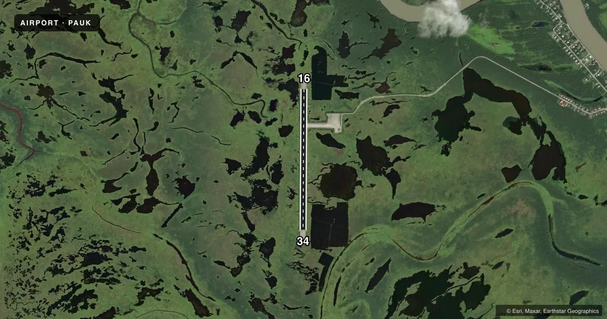
Airport sketch
Runways drawn to scale from FAA survey coordinates, rendered over satellite imagery. Not for navigation.
Approaches & charts
Services on the field
Fuel grades, oxygen, maintenance, ramp storage and lighting — as declared to the FAA by the airport operator.
Fuel & services
- Fuel
- Not available
- Oxygen (bottled)
- Not available
- Oxygen (bulk)
- Not available
- Airframe repair
- Not available
- Power plant repair
- Not available
Ramp & ground
- Transient storage
- Tie-down
- Landing fee
- No fee published
- Customs
- Not available
- Lighting schedule
- SEE RMK
- Beacon schedule
- SEE RMK
- Beacon
- White / Green (civil land)(WG)
- Wind indicator
- Lighted
- Segmented circle
- Yes
Fuel & FBOs
Cheapest 100LL and Jet A on the field and nearby. Always confirm with the FBO before taxi.
Airport notes
Surface conditions, obstructions, local procedures, lighting outages and other notes published with each FAA cycle.
General notes
- RY CONDITION NOT MONITORED; RECOMMEND VISUAL INSPECTION PRIOR TO LANDING.
- WATERFOWL ON & INVOF ARPT.
Lighting notes
- ACTVT ROTG BCN - CTAF.
- ACTVT MIRL RY 16/34 - CTAF.
VFR map & nearby airports
VFR sectional. Tap any ICAO chip to open that airport.
Key facts · PAUK
Answer card- ICAO
- PAUK
- Name
- ALAKANUK
- Location
- ALAKANUK, ALASKA
- Elevation
- 21.7 ft MSL
- Traffic pattern altitude
- 1,021.7 ft MSL (1,000 AGL)
- Control tower
- Non-towered (use CTAF)
- Total runways
- 1
- Longest runway
- 16/34 · 4,000 ft
- Published ILS approaches
- 0
- Published frequencies
- 1
- Magnetic variation
- 17°
- Current flight rules
- VFR
- Current wind
- Calm / unavailable
- Favored runway now
- –
Alakanuk Airport (PAUK) sits in Alakanuk, Alaska. The field elevation is 21.7 ft MSL. It has one runway. Runway 16/34 is 4,000 ft long and surfaced gravel-dirt. The airport is not towered. CTAF is 122.9.
No ILS approaches are published here. Pattern altitude is not published, so use 1,000 ft AGL for light piston traffic unless the current Chart Supplement says otherwise. The runway lights on 16/34 are activated by CTAF. The rotating beacon is also activated by CTAF.
This is a low-elevation Alaska field with a simple layout, but runway condition is not monitored. Plan a visual inspection before landing. Waterfowl are reported on and near the airport, so expect wildlife on the runway environment. There are no on-field FBOs listed in the facts, so verify fuel and services with the airport operator or call the field directly before arrival. With no tower and no published ILS, a current weather check and a solid VFR plan matter here.