METAR & TAF PFKO
Current METAR
Observed 09:56Z
PFKO 040956Z AUTO 02010KT 09/07 A3010 RMK AO2 SLP194 T00940067 PWINO RVRNO $
- Wind
- 020° @ 10 kt
- Visibility
- —
- Temp / Dew
- 9°C / 7°C
- Altimeter
- 30.10 inHg
- Clouds
- Clear
- Density alt
- -926 ft
- Ceiling
- Unlimited
- Rules
- VFR
Airport info & contacts
Manager on record, flight service, ARTCC, attendance schedule and pattern altitude — published by the FAA and refreshed every 28 days.
Location
- From city
- 1 NM W
- VFR sectional
- BETHEL
- ARTCC
- ZAN · ANCHORAGE
- NOTAM facility
- ENA (NOTAM-D)
Airport manager
- Name
- JOHN WILSON
- Phone
- (907) 625-1025
- Address
- BOX 192, UNALAKLEET AK 99684
Flight service · Hours
- FSS ENA
- KENAI907-283-72111-866-864-1737
- Attendance
- Unattended
Frequencies
Tap any row to copy the frequency to your clipboard.
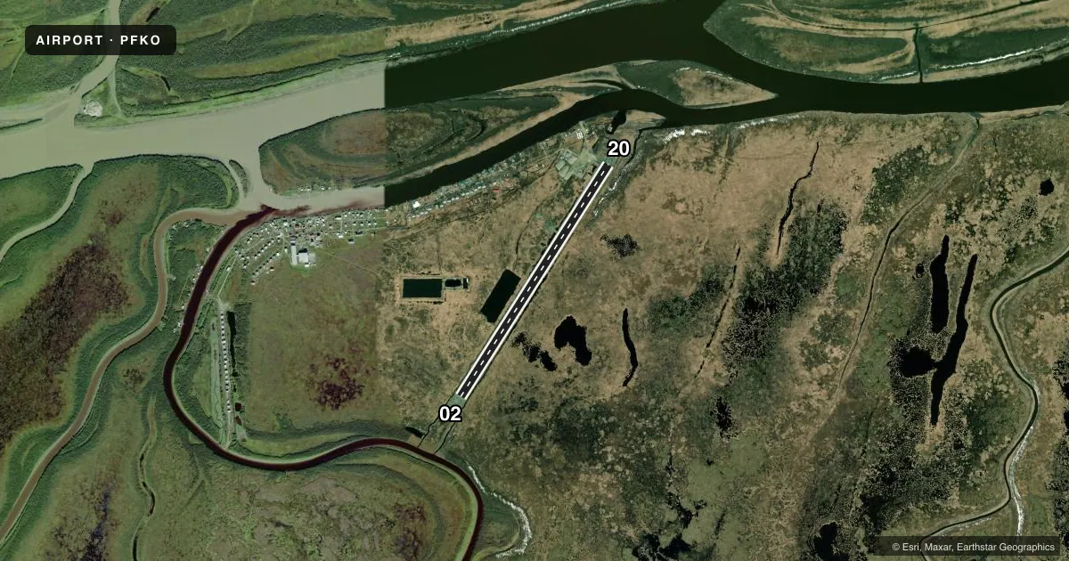
Runways & pattern
Full pagePattern entry · RWY 02
LEFT TRAFFICAirport sketch
Runways drawn to scale from FAA survey coordinates, rendered over satellite imagery. Not for navigation.
Approaches & charts
Services on the field
Fuel grades, oxygen, maintenance, ramp storage and lighting — as declared to the FAA by the airport operator.
Fuel & services
- Fuel
- Not available
Ramp & ground
- Transient storage
- Tie-down
- Lighting schedule
- SEE RMK
- Beacon schedule
- SEE RMK
- Beacon
- White / Green (civil land)(WG)
- Wind indicator
- Lighted
- Segmented circle
- Yes
Fuel & FBOs
Cheapest 100LL and Jet A on the field and nearby. Always confirm with the FBO before taxi.
Airport notes
Surface conditions, obstructions, local procedures, lighting outages and other notes published with each FAA cycle.
General notes
- RWY COND UNMNT; RCMD VISUAL INSP PRIOR TO LNDG.
- WX CAMERA AVBL ON INTERNET AT HTTPS://WEATHERCAMS.FAA.GOV
Lighting notes
- ACTVT ROTG BCN - CTAF.
- ACTVT MIRL RWY 02/20 - CTAF.
VFR map & nearby airports
VFR sectional. Tap any ICAO chip to open that airport.
Key facts · PFKO
Answer card- ICAO
- PFKO
- Name
- KOTLIK
- Location
- KOTLIK, ALASKA
- Elevation
- 13.6 ft MSL
- Traffic pattern altitude
- 1,013.6 ft MSL (1,000 AGL)
- Control tower
- Non-towered (use CTAF)
- Total runways
- 1
- Longest runway
- 02/20 · 4,400 ft
- Published ILS approaches
- 0
- Published frequencies
- 1
- Magnetic variation
- 15°
- Current flight rules
- VFR
- Current wind
- 020° at 10 kt
- Favored runway now
- RWY 02
Kotlik Airport sits in Kotlik, Alaska. The field elevation is 13.6 ft MSL. It has one runway. Runway 02/20 is 4,400 ft long and surfaced with gravel. The longest runway is 4,400 ft.
There is no control tower. CTAF is 122.9. No ILS approaches are published here. The published pattern altitude is not listed, so use standard traffic pattern planning only if the current Chart Supplement or local procedures support it. The airport sits in a low coastal Alaska environment. Weather and surface conditions can change fast. Runway condition is unmonitored, so a visual check before landing is a good idea.
Published remarks say the rotating beacon is keyed by the CTAF. The medium intensity runway lights for 02/20 are also activated by CTAF. A weather camera is available online for a current look at the field. No on-field FBOs are listed, so verify services with the airport operator or call ahead before you go. For a first trip in, pay close attention to the gravel surface, local weather and lighting activation on CTAF. Check the current FAA Chart Supplement for any additional airport notes before departure.