METAR & TAF PAAS
PAAS does not publish a METAR.
Showing the nearest reporting station: PAMK (ST MICHAEL) · 4.8 NM away. Conditions at PAAS may differ.
METAR · PAMK
Observed 06:56Z
PAMK 280656Z AUTO 32009KT 10SM CLR 12/06 A2993 RMK AO2 SLP138 T01170061
- Wind
- 320° @ 9 kt
- Visibility
- 10 SM
- Temp / Dew
- 12°C / 6°C
- Altimeter
- 29.93 inHg
- Clouds
- CLR
- Density alt
- -349 ft
- Ceiling
- Unlimited
- Rules
- VFR
Airport info & contacts
Manager on record, flight service, ARTCC, attendance schedule and pattern altitude — published by the FAA and refreshed every 28 days.
Location
- From city
- 0 NM NW
- VFR sectional
- BETHEL
- ARTCC
- ZAN · ANCHORAGE
- NOTAM facility
- OME (NOTAM-D)
Airport manager
- Name
- JOHN WILSON
- Phone
- 907-625-1025
- Address
- PO BOX 192, UNALAKLEET AK 99684
Flight service · Hours
- FSS OME
- NOMELC 443-22911-800-478-8400
- Attendance
- Unattended
Frequencies
Tap any row to copy the frequency to your clipboard.
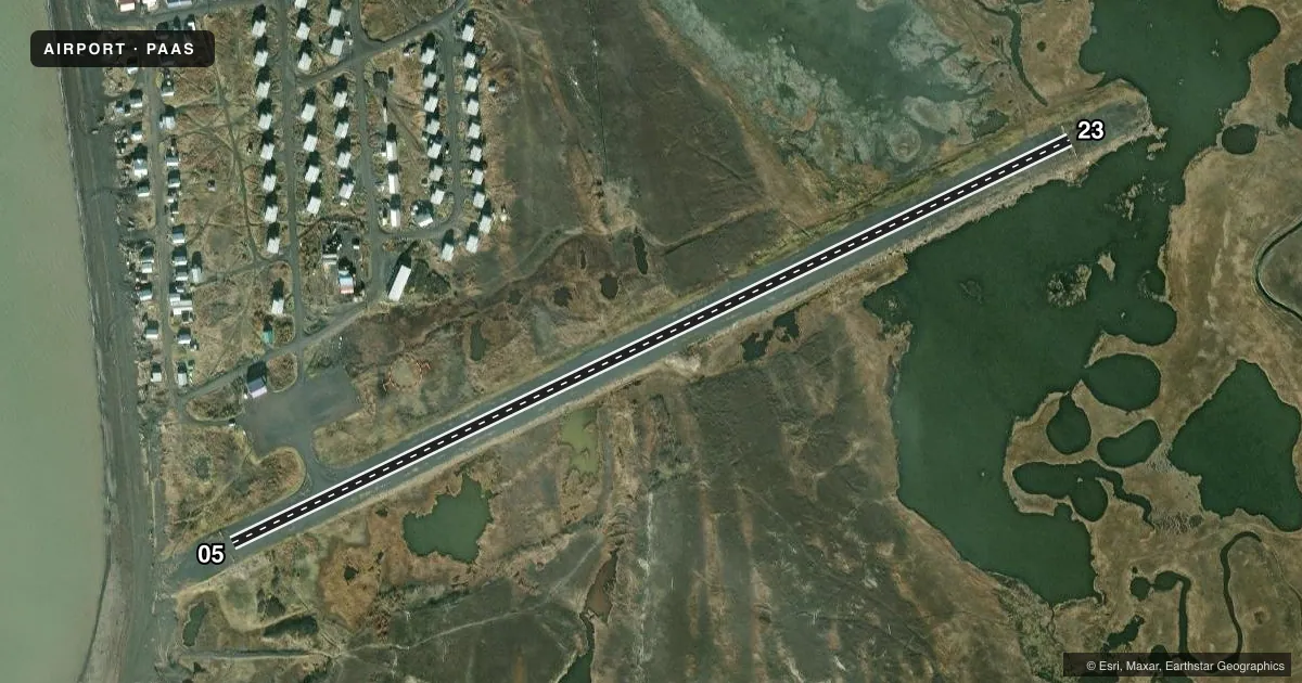
Runways & pattern
Full pagePattern entry · RWY 23
LEFT TRAFFICRunway end performance
| End | TORA | TODA | ASDA | LDA | VGSI | Approach lights | Obstruction |
|---|---|---|---|---|---|---|---|
| 05 | — | — | — | — | — | — | 38', hill, 1226' from thr, 150' R of cntrln, slope 31 |
Declared distances in feet. TORA = takeoff run available, TODA = takeoff distance, ASDA = accelerate-stop, LDA = landing distance.
Airport sketch
Runways drawn to scale from FAA survey coordinates, rendered over satellite imagery. Not for navigation.
Approaches & charts
Services on the field
Fuel grades, oxygen, maintenance, ramp storage and lighting — as declared to the FAA by the airport operator.
Fuel & services
- Fuel
- Not available
- Other services
- CARGO
Ramp & ground
- Transient storage
- Not published
- Landing fee
- No fee published
- Lighting schedule
- SEE RMK
- Beacon schedule
- SS-SR
- Beacon
- White / Green (civil land)(WG)
- Wind indicator
- Yes
- Segmented circle
- Yes
Fuel & FBOs
Cheapest 100LL and Jet A on the field and nearby. Always confirm with the FBO before taxi.
Airport notes
Surface conditions, obstructions, local procedures, lighting outages and other notes published with each FAA cycle.
General notes
- RWY COND UNMNT; RCMD VISUAL INSP BFR USE.
Lighting notes
- ACTVT MIRL RWY 05/23 - CTAF.
Runway surface & condition
- 05/23FLOODS DURG BREAKUP.
Other notes
- ESTABD PRIOR TO 1959.
VFR map & nearby airports
VFR sectional. Tap any ICAO chip to open that airport.
Key facts · PAAS
Answer card- ICAO
- PAAS
- Name
- STEBBINS
- Location
- STEBBINS, ALASKA
- Elevation
- 18.9 ft MSL
- Traffic pattern altitude
- 1,018.9 ft MSL (1,000 AGL)
- Control tower
- Non-towered (use CTAF)
- Total runways
- 1
- Longest runway
- 05/23 · 3,000 ft
- Published ILS approaches
- 0
- Published frequencies
- 2
- Magnetic variation
- 19°
- Current flight rules
- VFR
- Current wind
- 320° at 9 kt
- Favored runway now
- RWY 23