METAR & TAF PAUN
Current METAR
Observed 12:56Z
PAUN 281256Z AUTO 27014KT 10SM -RA SCT017 OVC029 11/08 A2999 RMK AO2 SLP157 P0000 T01060078
- Wind
- 270° @ 14 kt
- Visibility
- 10 SM
- Temp / Dew
- 11°C / 8°C
- Altimeter
- 29.99 inHg
- Clouds
- OVC
- Density alt
- -533 ft
- Ceiling
- 2,900 ft AGL
- Rules
- MVFR
Airport info & contacts
Manager on record, flight service, ARTCC, attendance schedule and pattern altitude — published by the FAA and refreshed every 28 days.
Location
- From city
- 1 NM N
- VFR sectional
- MC GRATH
- ARTCC
- ZAN · ANCHORAGE
- NOTAM facility
- UNK (NOTAM-D)
Airport manager
- Name
- JOHN WILSON
- Phone
- 907-625-1025
- Address
- PO BOX 192, UNALAKLEET AK 99684
Flight service · Hours
- FSS OME
- NOMELC 443-22911-800-478-8400
- Attendance
- MON-FRI · 0800-1600
Frequencies
Tap any row to copy the frequency to your clipboard.
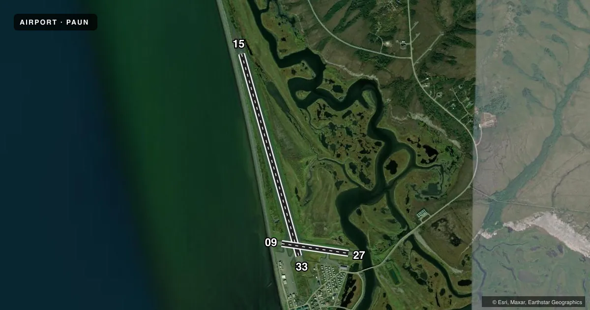
Runways & pattern
Full pagePattern entry · RWY 27
LEFT TRAFFIC| Runway | Heading (°M) | Length | Surface | Traffic |
|---|---|---|---|---|
| 15/33 | 153° / 333° | 5,900 ft | ASPH | 15 R |
| 09/27Favored | 87° / 267° | 1,900 ft | ASPH | Standard L |
Runway end performance
| End | TORA | TODA | ASDA | LDA | VGSI | Approach lights | Obstruction |
|---|---|---|---|---|---|---|---|
| 15 | — | — | — | — | VASI 4-box left(3°) | — | 15', road, 200' from thr, 110' R of cntrln, slope 0 |
| 33 | — | — | — | — | VASI 4-box left(3°) | — | 25', bldg, 850' from thr, 300' R of cntrln, slope 26 |
| 27 | — | — | — | — | — | — | 20', brdg, 690' from thr, 310' R of cntrln, slope 24 |
Declared distances in feet. TORA = takeoff run available, TODA = takeoff distance, ASDA = accelerate-stop, LDA = landing distance.
Airport sketch
Runways drawn to scale from FAA survey coordinates, rendered over satellite imagery. Not for navigation.
Approaches & charts
ILS · 1
Services on the field
Fuel grades, oxygen, maintenance, ramp storage and lighting — as declared to the FAA by the airport operator.
Fuel & services
- Fuel
- 100LLA
- Other services
- CARGO
Ramp & ground
- Transient storage
- Tie-down
- Landing fee
- No fee published
- Customs
- Not available
- Lighting schedule
- SEE RMK
- Beacon schedule
- SS-SR
- Beacon
- White / Green (civil land)(WG)
- Wind indicator
- Yes
- Segmented circle
- Yes
Fuel & FBOs
Cheapest 100LL and Jet A on the field and nearby. Always confirm with the FBO before taxi.
Airport notes
Surface conditions, obstructions, local procedures, lighting outages and other notes published with each FAA cycle.
General notes
- 299 FT TWR 2.4 NM E.
- SNOW REMOVAL & DEICING NA 1600-0800.
- RWY COND UNMNT; RCMD VISUAL INSP PRIOR TO LNDG.
- WX CAMERA AVBL ON INTERNET AT HTTPS://WEATHERCAMS.FAA.GOV.
Lighting notes
- ACTVT REIL RWY 33; HIRL RWY 15/33; MIRL RWY 09/27 - CTAF. VASI RWY 15 & 33 ON CONSLY.
Approach & departure obstructions
- 15100 FT UNLGT TWR 0.4 NM N OF THR.
Other notes
- EMERG ONLY.
- ESTAB PRIOR TO 1959.
- EMERG ONLY.
- TSNT PRKG NEAR DOT MAINT BLDG & RWY 27 THR.
- MANAGEREMAIL: JOHN.WILSON@ALASKA.GOV
VFR map & nearby airports
VFR sectional. Tap any ICAO chip to open that airport.
Key facts · PAUN
Answer card- ICAO
- PAUN
- Name
- UNALAKLEET
- Location
- UNALAKLEET, ALASKA
- Elevation
- 27.3 ft MSL
- Traffic pattern altitude
- 1,027.3 ft MSL (1,000 AGL)
- Control tower
- Non-towered (use CTAF)
- Total runways
- 2
- Longest runway
- 15/33 · 5,900 ft
- Published ILS approaches
- 1
- Published frequencies
- 1
- Magnetic variation
- 11°
- Current flight rules
- MVFR
- Current wind
- 270° at 14 kt
- Favored runway now
- RWY 27
Unalakleet Airport sits in Unalakleet, Alaska. Field elevation is 27.3 ft MSL. The airport has two asphalt runways. The longest is runway 15/33 at 5,900 ft. There is no control tower. CTAF is 123.0. One ILS approach is published for runway 15.
Pattern altitude is not published. Use 1,000 ft AGL as the standard light-piston pattern reference unless the current Chart Supplement says otherwise. West Coast Aviation Services is on the field. It carries AVGAS 100LL and JET A. Call (907) 624-3461 for current service details before arrival.
A few published remarks matter here. Transient parking is near the Department of Transportation maintenance building and the runway 27 threshold. Snow removal and deicing are not available from 1600 to 0800. Runway condition is unmonitored. Plan a visual inspection before landing if conditions are uncertain. There is also a 299-foot tower 2.4 NM east. A 100-foot unlighted tower sits 0.4 NM north of the runway 15 threshold. Runway 15 and runway 33 have high intensity lighting. Runway 09 and runway 27 have medium intensity lighting. All lighting is controlled by CTAF. For a first-time arrival, pay close attention to the terrain-free but weather-prone Alaska environment. Also note the unmonitored surface and the tower and lighting notes before you commit to final.