METAR & TAF PANV
Current METAR
Observed 04:56Z
PANV 280456Z AUTO 24005KT 10SM BKN033 OVC044 12/10 A2994 RMK AO2 SLP206 T01220100 TSNO
- Wind
- 240° @ 5 kt
- Visibility
- 10 SM
- Temp / Dew
- 12°C / 10°C
- Altimeter
- 29.94 inHg
- Clouds
- OVC
- Density alt
- -16 ft
- Ceiling
- 3,300 ft AGL
- Rules
- VFR
Airport info & contacts
Manager on record, flight service, ARTCC, attendance schedule and pattern altitude — published by the FAA and refreshed every 28 days.
Location
- From city
- 1 NM SE
- VFR sectional
- MC GRATH
- ARTCC
- ZAN · ANCHORAGE
- NOTAM facility
- ANV (NOTAM-D)
Airport manager
- Name
- ERIK WEINGARTH
- Phone
- 907-438-2416
- Address
- BOX 135, ST MARY'S AK 99658
Flight service · Hours
- FSS ENA
- KENAI907-283-72111-866-864-1737
- Attendance
- Unattended
Frequencies
Tap any row to copy the frequency to your clipboard.
Runways & pattern
Full pagePattern entry · RWY 17
LEFT TRAFFICRunway end performance
| End | TORA | TODA | ASDA | LDA | VGSI | Approach lights | Obstruction |
|---|---|---|---|---|---|---|---|
| 17 | — | — | — | — | PAPI 4-box left(3°) | — | 7', brush, 0' from thr, 135' R of cntrln, slope 0 |
| 35 | — | — | — | — | PAPI 4-box left(3°) | — | 10', brush, 0' from thr, 245' R of cntrln, slope 0 |
Declared distances in feet. TORA = takeoff run available, TODA = takeoff distance, ASDA = accelerate-stop, LDA = landing distance.
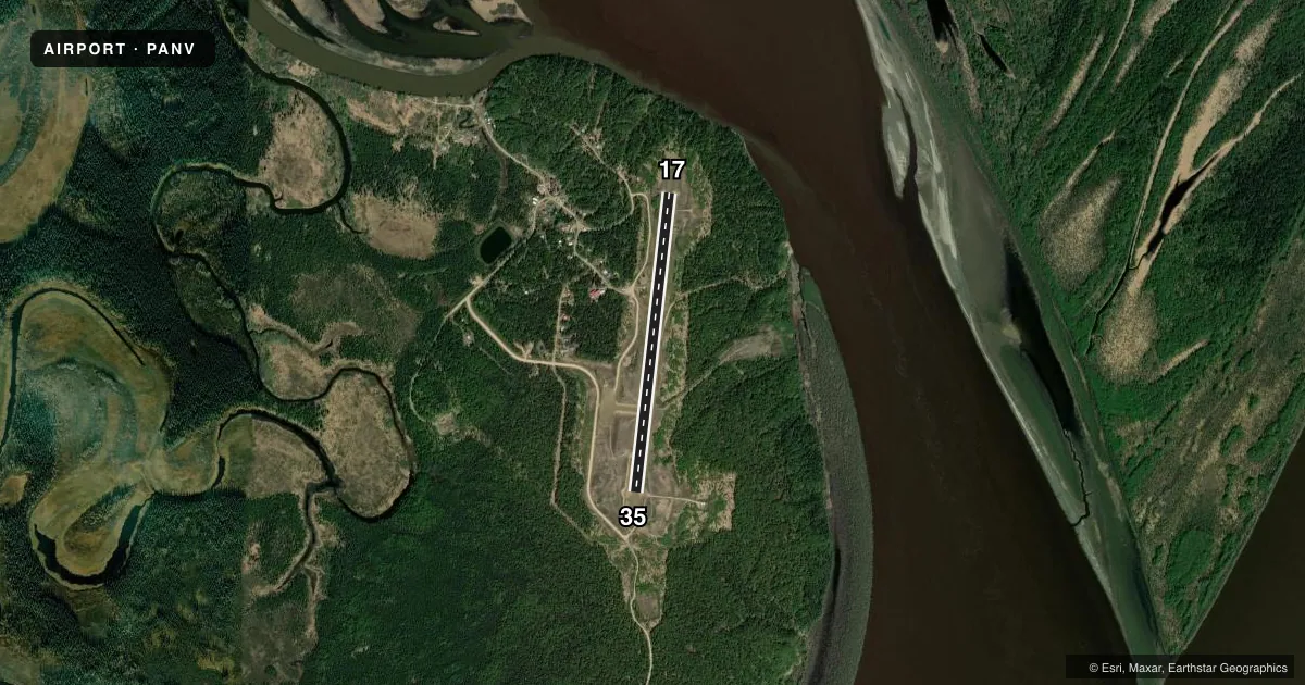
Airport sketch
Runways drawn to scale from FAA survey coordinates, rendered over satellite imagery. Not for navigation.
Approaches & charts
Services on the field
Fuel grades, oxygen, maintenance, ramp storage and lighting — as declared to the FAA by the airport operator.
Fuel & services
- Fuel
- Not available
Ramp & ground
- Transient storage
- Not published
- Landing fee
- No fee published
- Lighting schedule
- SEE RMK
- Beacon schedule
- SS-SR
- Beacon
- White / Green (civil land)(WG)
- Wind indicator
- Lighted
- Segmented circle
- Yes
Fuel & FBOs
Cheapest 100LL and Jet A on the field and nearby. Always confirm with the FBO before taxi.
Airport notes
Surface conditions, obstructions, local procedures, lighting outages and other notes published with each FAA cycle.
General notes
- RY COND NOT MONITORED; RCMD VISUAL INSPECTION PRIOR TO LNDG.
- WX CAMERA AVBL ON INTERNET AT HTTPS://WEATHERCAMS.FAA.GOV
- RADIO AIDS TO NAVIGATION - NDB/DME OTS INDEF
Lighting notes
- ACTVT MIRL RY 17/35, PAPIS RWY 17 &35, REILS RWY 17& 35 --122.7.
Other notes
- 77 FT TREES 200 FT EAST OF WINDSOCK MAY RESULT IN ERRONEOUS WIND INDICATIONS.
VFR map & nearby airports
VFR sectional. Tap any ICAO chip to open that airport.
Key facts · PANV
Answer card- ICAO
- PANV
- Name
- ANVIK
- Location
- ANVIK, ALASKA
- Elevation
- 297.3 ft MSL
- Traffic pattern altitude
- 1,297.3 ft MSL (1,000 AGL)
- Control tower
- Non-towered (use CTAF)
- Total runways
- 1
- Longest runway
- 17/35 · 4,000 ft
- Published ILS approaches
- 0
- Published frequencies
- 2
- Magnetic variation
- 15°
- Current flight rules
- VFR
- Current wind
- 240° at 5 kt
- Favored runway now
- RWY 17
Anvik Airport sits in Anvik, Alaska. The field elevation is 297.3 ft MSL. It has one runway, 17/35, which is 4,000 ft long and surfaced with gravel. The airport is not towered. CTAF and UNICOM are both 122.7. No ILS approaches are published here.
Pattern altitude is not published. Use 1,000 ft AGL as the standard light piston pattern unless local guidance or the current Chart Supplement says otherwise. The runway headings are 186° and 6° magnetic. That matters here because the magnetic variation is 15°.
There are no on-field FBOs listed, so plan on confirming services before you go. Published remarks say runway condition is not monitored, so a visual check before landing is smart. Trees about 200 feet east of the windsock can give you a bad wind read. Runway 17/35 has medium intensity lights, PAPI on both ends and runway end identifier lights. Those lights are activated on 122.7. Radio aids to navigation, including NDB and DME, are out of service indefinitely. For a first-time arrival, treat this as a remote gravel strip. Verify runway condition, wind and lighting status before you commit.