METAR & TAF PAGX
PAGX does not publish a METAR.
Showing the nearest reporting station: PANV (ANVIK) · 15.1 NM away. Conditions at PAGX may differ.
METAR · PANV
Observed 18:11Z
PANV 271811Z AUTO 25005KT 2SM RA BR OVC002 11/11 A2984 RMK AO2 VIS 1 1/4V4 P0002 TSNO
- Wind
- 250° @ 5 kt
- Visibility
- 2 SM
- Temp / Dew
- 11°C / 11°C
- Altimeter
- 29.84 inHg
- Clouds
- OVC
- Density alt
- -210 ft
- Ceiling
- 200 ft AGL
- Rules
- LIFR
Airport info & contacts
Manager on record, flight service, ARTCC, attendance schedule and pattern altitude — published by the FAA and refreshed every 28 days.
Location
- From city
- 1 NM S
- VFR sectional
- MC GRATH
- ARTCC
- ZAN · ANCHORAGE
- NOTAM facility
- ENA (NOTAM-D)
Airport manager
- Name
- ERIC WEINGARTH
- Phone
- (907) 438-2416
- Address
- PO BOX 1048, NOME AK 99762
Flight service · Hours
- FSS ENA
- KENAI907-283-72111-866-864-1737
- Attendance
- Unattended
Frequencies
Tap any row to copy the frequency to your clipboard.
Runways & pattern
Full pagePattern entry · RWY 17
LEFT TRAFFICRunway end performance
| End | TORA | TODA | ASDA | LDA | VGSI | Approach lights | Obstruction |
|---|---|---|---|---|---|---|---|
| 17 | — | — | — | — | — | — | 10', brush, 0' from thr, 115' R of cntrln, slope 0 |
| 35 | — | — | — | — | — | — | 4', brush, 4' from thr, 85' R of cntrln, slope 0 |
Declared distances in feet. TORA = takeoff run available, TODA = takeoff distance, ASDA = accelerate-stop, LDA = landing distance.
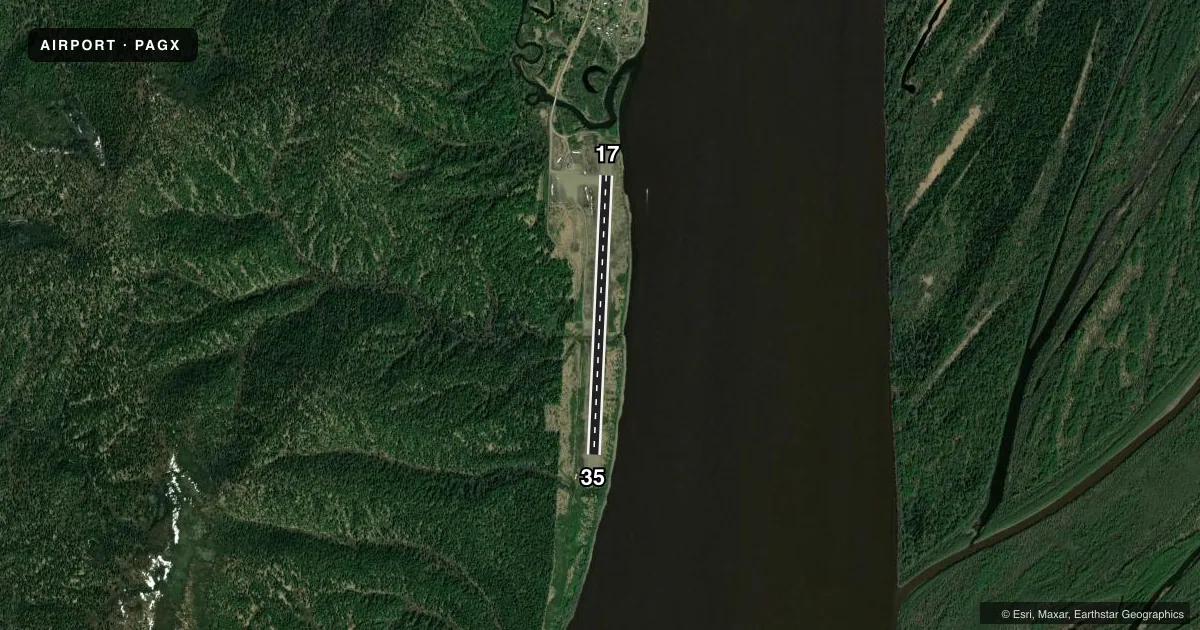
Airport sketch
Runways drawn to scale from FAA survey coordinates, rendered over satellite imagery. Not for navigation.
Approaches & charts
Services on the field
Fuel grades, oxygen, maintenance, ramp storage and lighting — as declared to the FAA by the airport operator.
Fuel & services
- Fuel
- Not available
- Oxygen (bottled)
- Not available
- Oxygen (bulk)
- Not available
- Airframe repair
- Not available
- Power plant repair
- Not available
- Other services
- CARGO
Ramp & ground
- Transient storage
- Tie-down
- Landing fee
- No fee published
- Customs
- Not available
- Lighting schedule
- SEE RMK
- Beacon schedule
- SS-SR
- Beacon
- White / Green (civil land)(WG)
- Wind indicator
- Lighted
- Segmented circle
- Yes
Fuel & FBOs
Cheapest 100LL and Jet A on the field and nearby. Always confirm with the FBO before taxi.
Airport notes
Surface conditions, obstructions, local procedures, lighting outages and other notes published with each FAA cycle.
General notes
- RY COND NOT MONITORED; RCMD VISUAL INSPECTION PRIOR TO LNDG.
- WX CAMERA AVBL ON INTERNET AT HTTPS://WEATHERCAMS.FAA.GOV
- RISING TERRAIN N & W.
- RWY SLOPES UP TO SOUTH.
- COLD TEMPERATURE AIRPORT. ALTITUDE CORRECTION REQUIRED AT OR BELOW -23C.
- WIND SOCK AND SEGMENTED CIRCLE AND OVERGROWN WITH BRUSH AND MAY BE UNRELIABLE
Lighting notes
- ACTVT MIRL RY 17/35 - CTAF.
VFR map & nearby airports
VFR sectional. Tap any ICAO chip to open that airport.
Key facts · PAGX
Answer card- ICAO
- PAGX
- Name
- GRAYLING
- Location
- GRAYLING, ALASKA
- Elevation
- 137.5 ft MSL
- Traffic pattern altitude
- 1,137.5 ft MSL (1,000 AGL)
- Control tower
- Non-towered (use CTAF)
- Total runways
- 1
- Longest runway
- 17/35 · 4,000 ft
- Published ILS approaches
- 0
- Published frequencies
- 1
- Magnetic variation
- 12°
- Current flight rules
- LIFR
- Current wind
- 250° at 5 kt
- Favored runway now
- RWY 17
Grayling Airport (PAGX) sits in Grayling, Alaska. Field elevation is 137.5 ft MSL. The airport has one runway. Runway 17/35 is 4,000 ft long and gravel. The field is non-towered. CTAF is 122.9.
No ILS approaches are published here. Pattern altitude is not published, so use the standard 1,000 ft AGL for light piston operations unless the current Chart Supplement says otherwise. The runway lights on 17/35 are activated by CTAF. That matters after dark or in low visibility.
This is a cold temperature airport. Altitude correction is required at or below minus 23 degrees Celsius. Runway condition is not monitored. A visual check before landing is a good idea. The wind sock and segmented circle are overgrown with brush, so treat them as unreliable. Runway 17/35 slopes up to the south. Rising terrain is located to the north and west. There is no on-field FBO listed, so plan fuel and services with the airport operator or the FBO directly by phone before you go.