METAR & TAF PACJ
PACJ does not publish a METAR.
Showing the nearest reporting station: PASL (SLEETMUTE) · 29.4 NM away. Conditions at PACJ may differ.
METAR · PASL
Observed 23:56Z
PASL 272356Z AUTO VRB03KT 10SM -RA OVC028 13/09 A2999 RMK AO2 SLP145 P0000 60005 T01280089 10128 20106 53014
- Wind
- VAR @ 3 kt
- Visibility
- 10 SM
- Temp / Dew
- 13°C / 9°C
- Altimeter
- 29.99 inHg
- Clouds
- OVC
- Density alt
- -107 ft
- Ceiling
- 2,800 ft AGL
- Rules
- MVFR
Airport info & contacts
Manager on record, flight service, ARTCC, attendance schedule and pattern altitude — published by the FAA and refreshed every 28 days.
Location
- From city
- 2 NM S
- VFR sectional
- MC GRATH
- ARTCC
- ZAN · ANCHORAGE
- NOTAM facility
- ENA (NOTAM-D)
Airport manager
- Name
- KEN SMITH
- Phone
- 907-676-0505
- Address
- PO BOX 73, ANIAK AK 99557
Flight service · Hours
- FSS ENA
- KENAI907-283-72111-866-864-1737
- Attendance
- Unattended
Frequencies
Tap any row to copy the frequency to your clipboard.
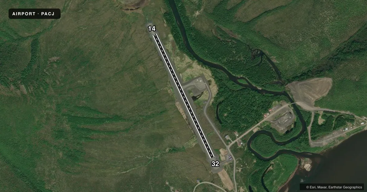
Runways & pattern
Full pagePattern entry · RWY 32
LEFT TRAFFICAirport sketch
Runways drawn to scale from FAA survey coordinates, rendered over satellite imagery. Not for navigation.
Approaches & charts
Services on the field
Fuel grades, oxygen, maintenance, ramp storage and lighting — as declared to the FAA by the airport operator.
Fuel & services
- Fuel
- MOGAS
Ramp & ground
- Transient storage
- Not published
- Landing fee
- No fee published
- Beacon schedule
- SS-SR
- Beacon
- White / Green (civil land)(WG)
- Wind indicator
- Lighted
- Segmented circle
- Yes
Fuel & FBOs
Cheapest 100LL and Jet A on the field and nearby. Always confirm with the FBO before taxi.
Airport notes
Surface conditions, obstructions, local procedures, lighting outages and other notes published with each FAA cycle.
General notes
- RWY COND UNMNT; RCMD VISUAL INSP BFR USE.
Runway surface & condition
- 14/32SLOPES DOWN TO S. LINE OF SIGHT BTN ENDS NA.
Approach & departure obstructions
- 32FIRST 100 FT CLSD INDEFLY.
VFR map & nearby airports
VFR sectional. Tap any ICAO chip to open that airport.
Key facts · PACJ
Answer card- ICAO
- PACJ
- Name
- CROOKED CREEK
- Location
- CROOKED CREEK, ALASKA
- Elevation
- 177.2 ft MSL
- Traffic pattern altitude
- 1,177.2 ft MSL (1,000 AGL)
- Control tower
- Non-towered (use CTAF)
- Total runways
- 1
- Longest runway
- 14/32 · 3,300 ft
- Published ILS approaches
- 0
- Published frequencies
- 1
- Magnetic variation
- 11°
- Current flight rules
- MVFR
- Current wind
- 000° at 3 kt
- Favored runway now
- RWY 32
Crooked Creek Airport (PACJ) sits in Crooked Creek, Alaska. The field elevation is 177.2 ft MSL. It has one runway, 14/32, which is 3,300 ft long and gravel. The airport is not towered. CTAF is 122.8.
No ILS approaches are published here. The published pattern altitude is not listed, so use the standard 1,000 ft AGL for light piston operations unless the current FAA Chart Supplement says otherwise. With the field in rural Alaska, expect a simple non-towered environment. Plan for local weather, surface condition and daylight carefully.
The published remarks matter here. The first 100 ft of runway 32 is indefinitely closed. The runway also slopes down to the south. Line of sight between the ends is not available, so a careful low pass or taxi check makes sense before committing to landing. Runway condition is unmonitored, so a visual inspection before use is a good idea. No on-field FBOs are listed, so verify services with the airport operator or call on CTAF before arrival.