METAR & TAF PASL
Current METAR
Observed 06:56Z
PASL 280656Z AUTO VRB05KT 10SM OVC060 13/07 A3003 RMK AO2 SLP159 T01330072
- Wind
- VAR @ 5 kt
- Visibility
- 10 SM
- Temp / Dew
- 13°C / 7°C
- Altimeter
- 30.03 inHg
- Clouds
- OVC
- Density alt
- -139 ft
- Ceiling
- 6,000 ft AGL
- Rules
- VFR
Airport info & contacts
Manager on record, flight service, ARTCC, attendance schedule and pattern altitude — published by the FAA and refreshed every 28 days.
Location
- From city
- 0 NM E
- VFR sectional
- MC GRATH
- ARTCC
- ZAN · ANCHORAGE
- NOTAM facility
- SLQ (NOTAM-D)
Airport manager
- Name
- KEN SMITH
- Phone
- 907-676-0505
- Address
- PO BOX 196900, ANCHORAGE AK 99519-7300
Flight service · Hours
- FSS ENA
- KENAI907-283-72111-866-864-1737
- Attendance
- Unattended
Frequencies
Tap any row to copy the frequency to your clipboard.
Runways & pattern
Full pagePattern entry · RWY 33
LEFT TRAFFICRunway end performance
| End | TORA | TODA | ASDA | LDA | VGSI | Approach lights | Obstruction |
|---|---|---|---|---|---|---|---|
| 15 | — | — | — | — | — | — | 12', brush, 0' from thr, 110' R of cntrln, slope 0 |
| 33 | — | — | — | — | — | — | 28', tree, 0' from thr, 120' R of cntrln, slope 0 |
Declared distances in feet. TORA = takeoff run available, TODA = takeoff distance, ASDA = accelerate-stop, LDA = landing distance.
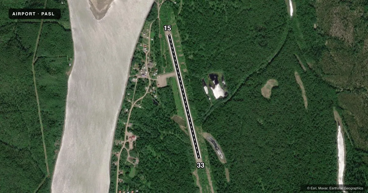
Airport sketch
Runways drawn to scale from FAA survey coordinates, rendered over satellite imagery. Not for navigation.
Approaches & charts
Services on the field
Fuel grades, oxygen, maintenance, ramp storage and lighting — as declared to the FAA by the airport operator.
Fuel & services
- Fuel
- 100LL
Ramp & ground
- Transient storage
- Not published
- Landing fee
- No fee published
- Customs
- Not available
- Lighting schedule
- SEE RMK
- Beacon schedule
- SS-SR
- Beacon
- White / Green (civil land)(WG)
- Wind indicator
- Yes
- Segmented circle
- No
Fuel & FBOs
Cheapest 100LL and Jet A on the field and nearby. Always confirm with the FBO before taxi.
Airport notes
Surface conditions, obstructions, local procedures, lighting outages and other notes published with each FAA cycle.
General notes
- RWY COND UNMNT; RCMD VISUAL INSP BFR USE.
- ATVS ON OR INVOF RWY.
- RED DEVIL ARPT 8 MI NW.
- WX CAMERA AVBL ON INTERNET AT HTTPS://WEATHERCAMS.FAA.GOV.
- COLD TEMPERATURE AIRPORT. ALTITUDE CORRECTION REQUIRED AT OR BELOW -36C.
Lighting notes
- ACTVT MIRL RWY 15/33 - CTAF.
Fuel notes
- 100LLAVBL - CTAF OR 907-449-4227.
Approach & departure obstructions
- 15END LGTS.
- 33END LGTS.
Other notes
- ESTABD PRIOR TO 1959.
- 15/33N 500 FT SOFT; RMNDR SOFT SPOTS.
VFR map & nearby airports
VFR sectional. Tap any ICAO chip to open that airport.
Key facts · PASL
Answer card- ICAO
- PASL
- Name
- SLEETMUTE
- Location
- SLEETMUTE, ALASKA
- Elevation
- 191.6 ft MSL
- Traffic pattern altitude
- 1,191.6 ft MSL (1,000 AGL)
- Control tower
- Non-towered (use CTAF)
- Total runways
- 1
- Longest runway
- 15/33 · 3,100 ft
- Published ILS approaches
- 0
- Published frequencies
- 2
- Magnetic variation
- 13°
- Current flight rules
- VFR
- Current wind
- 000° at 5 kt
- Favored runway now
- RWY 33
Sleetmute Airport is in Sleetmute, Alaska. Field elevation is 191.6 ft MSL. The airport has one runway. Runway 15/33 is 3,100 ft long and surfaced with gravel. There is no control tower. CTAF and UNICOM are both 122.8. No ILS approaches are published here.
Pattern altitude is not published in the Chart Supplement. For light piston operations, use the standard 1,000 ft AGL pattern unless local conditions or current guidance call for something different. The field is a cold temperature airport. Altitude correction is required at or below minus 36 degrees Celsius. Runway condition is unmonitored. A visual inspection before use is recommended. The north 500 ft of the runway is soft. The rest of the runway has soft spots.
Medium intensity runway lights on 15/33 are activated by CTAF. Runway 15 has end lights. Runway 33 has end lights. 100LL is available on CTAF or by calling the number in the Chart Supplement. No on-field FBOs are listed. First-time arrivals should plan for a gravel strip with soft areas, cold-weather performance effects and no published instrument approach support. Red Devil Airport is 8 miles northwest.