METAR & TAF FLT
FLT does not publish a METAR.
Showing the nearest reporting station: PAHX (SHAGELUK) · 46.1 NM away. Conditions at FLT may differ.
METAR · PAHX
Observed 05:02Z
PAHX 280502Z AUTO 25007KT 10SM OVC040 13/11 A2996 RMK AO2 SLPNO T01280106
- Wind
- 250° @ 7 kt
- Visibility
- 10 SM
- Temp / Dew
- 13°C / 11°C
- Altimeter
- 29.96 inHg
- Clouds
- OVC
- Density alt
- 136 ft
- Ceiling
- 4,000 ft AGL
- Rules
- VFR
Airport info & contacts
Manager on record, flight service, ARTCC, attendance schedule and pattern altitude — published by the FAA and refreshed every 28 days.
Location
- From city
- 0 NM E
- VFR sectional
- MC GRATH
- ARTCC
- ZAN · ANCHORAGE
- NOTAM facility
- ENA (NOTAM-D)
Airport manager
- Name
- STEFFEN STRICK
- Phone
- 907-524-3241
- Address
- PO BOX 21, MCGRATH AK 99627
Flight service · Hours
- FSS ENA
- KENAI907-283-72111-866-864-1737
- Attendance
- Unattended
Frequencies
Tap any row to copy the frequency to your clipboard.
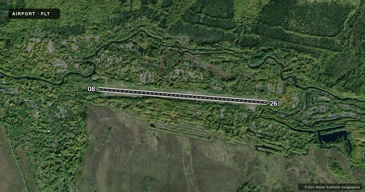
Runways & pattern
Full pagePattern entry · RWY 26
LEFT TRAFFICRunway end performance
| End | TORA | TODA | ASDA | LDA | VGSI | Approach lights | Obstruction |
|---|---|---|---|---|---|---|---|
| 08 | — | — | — | — | — | — | 38', trees, 0' from thr, 120' R of cntrln, slope 0 |
| 26 | — | — | — | — | — | — | 18', trees, 0' from thr, 85' R of cntrln, slope 0 |
Declared distances in feet. TORA = takeoff run available, TODA = takeoff distance, ASDA = accelerate-stop, LDA = landing distance.
Airport sketch
Runways drawn to scale from FAA survey coordinates, rendered over satellite imagery. Not for navigation.
Approaches & charts
Services on the field
Fuel grades, oxygen, maintenance, ramp storage and lighting — as declared to the FAA by the airport operator.
Fuel & services
- Fuel
- Not available
- Other services
- CARGO
Ramp & ground
- Transient storage
- Not published
- Landing fee
- No fee published
- Customs
- Not available
- Wind indicator
- Yes
- Segmented circle
- No
Fuel & FBOs
Cheapest 100LL and Jet A on the field and nearby. Always confirm with the FBO before taxi.
Airport notes
Surface conditions, obstructions, local procedures, lighting outages and other notes published with each FAA cycle.
General notes
- RWY COND UNMNT; RCMD VISUAL INSP BFR USE.
Runway surface & condition
- 08/26NORTH 150 FT UNUSABLE. TREES, GRASS & SHRUBS ALG RWY. RWY NOT MNTND.
Approach & departure obstructions
- 083 FT ORANGE CONES & THR PANELS; OVERGROWN MAY NOT BE VISIBLE.
- 263 FT ORANGE CONES & THR PANELS; OVERGROWN MAY NOT BE VISIBLE.
Other notes
- ESTABD PRIOR TO 1959.
- 08/2612-30 IN GRASS & BRUSH. SOFT WHEN WET.
VFR map & nearby airports
VFR sectional. Tap any ICAO chip to open that airport.
Key facts · FLT
Answer card- ICAO
- FLT
- Name
- FLAT
- Location
- FLAT, ALASKA
- Elevation
- 343 ft MSL
- Traffic pattern altitude
- 1,343 ft MSL (1,000 AGL)
- Control tower
- Non-towered (use CTAF)
- Total runways
- 1
- Longest runway
- 08/26 · 4,045 ft
- Published ILS approaches
- 0
- Published frequencies
- 1
- Magnetic variation
- 21°
- Current flight rules
- VFR
- Current wind
- 250° at 7 kt
- Favored runway now
- RWY 26
Flat Airport sits in FLAT, Alaska. Field elevation is 343 ft MSL. The airport has one runway. Runway 08/26 is 4,045 ft long and uses turf-gravel. There is no control tower. CTAF is 122.9.
No ILS approaches are published here. Pattern altitude is not published, so use the standard 1,000 ft AGL pattern for light piston operations unless the current FAA Chart Supplement says otherwise. The runway is unmaintained. The published remarks say the north 150 ft is unusable. Trees, grass and shrubs line the runway. The surface can be soft when wet. A visual inspection before landing makes sense here.
Published remarks also note 3-foot orange cones and threshold panels near both runway ends. They may be overgrown and hard to see. Runway 08 and Runway 26 both have that note. The airport was established before 1959.
There are no on-field FBOs listed. Contact the airport operator directly before arrival, or call the field on CTAF for current service status. For a first-time arrival, the main items are the unmaintained surface, the soft-wet condition and the unusable north end of the runway. Check the current FAA Chart Supplement for any noise or operating notes before you go.