METAR & TAF SRV
SRV does not publish a METAR.
Showing the nearest reporting station: PASL (SLEETMUTE) · 17.3 NM away. Conditions at SRV may differ.
METAR · PASL
Observed 03:56Z
PASL 280356Z AUTO VRB05KT 10SM FEW045 OVC055 15/07 A3000 RMK AO2 SLP150 T01500072
- Wind
- VAR @ 5 kt
- Visibility
- 10 SM
- Temp / Dew
- 15°C / 7°C
- Altimeter
- 30.00 inHg
- Clouds
- OVC
- Density alt
- 186 ft
- Ceiling
- 5,500 ft AGL
- Rules
- VFR
Airport info & contacts
Manager on record, flight service, ARTCC, attendance schedule and pattern altitude — published by the FAA and refreshed every 28 days.
Location
- From city
- 0 NM N
- VFR sectional
- MC GRATH
- ARTCC
- ZAN · ANCHORAGE
- NOTAM facility
- ENA (NOTAM-D)
Airport manager
- Name
- KEN SMITH
- Phone
- 907-676-0505
- Address
- PO BOX 196900, ANCHORAGE AK 99519
Flight service · Hours
- FSS ENA
- KENAI907-283-72111-866-864-1737
- Attendance
- Unattended
Frequencies
Tap any row to copy the frequency to your clipboard.
Runways & pattern
Full pagePattern entry · RWY 36
LEFT TRAFFICRunway end performance
| End | TORA | TODA | ASDA | LDA | VGSI | Approach lights | Obstruction |
|---|---|---|---|---|---|---|---|
| 18 | — | — | — | — | — | — | 25', trees, 0' from thr, 90' R of cntrln, slope 0 |
| 36 | — | — | — | — | — | — | 42', trees, 0' from thr, 120' R of cntrln, slope 0 |
Declared distances in feet. TORA = takeoff run available, TODA = takeoff distance, ASDA = accelerate-stop, LDA = landing distance.
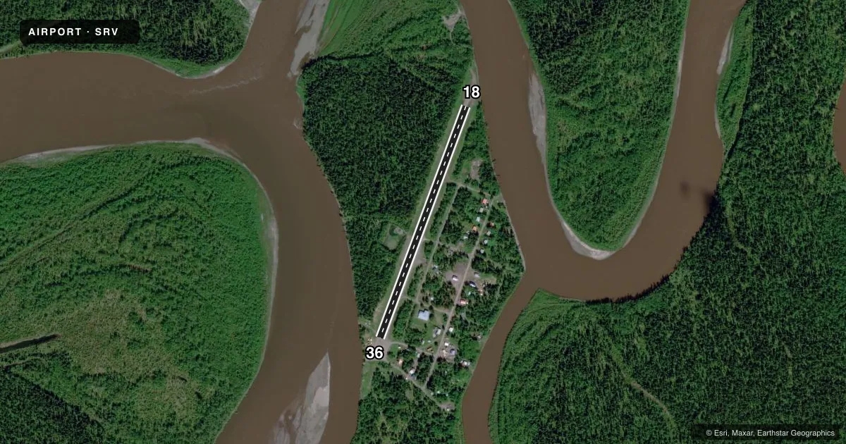
Airport sketch
Runways drawn to scale from FAA survey coordinates, rendered over satellite imagery. Not for navigation.
Approaches & charts
Services on the field
Fuel grades, oxygen, maintenance, ramp storage and lighting — as declared to the FAA by the airport operator.
Fuel & services
- Fuel
- Not available
Ramp & ground
- Transient storage
- Not published
- Landing fee
- No fee published
- Customs
- Not available
- Wind indicator
- Yes
- Segmented circle
- No
Fuel & FBOs
Cheapest 100LL and Jet A on the field and nearby. Always confirm with the FBO before taxi.
Airport notes
Surface conditions, obstructions, local procedures, lighting outages and other notes published with each FAA cycle.
General notes
- RWY COND UNMNT; RCMD VISUAL INSP BFR USE.
- BOATS STORED NEAR SOUTH END OF RY.
Runway surface & condition
- 18/3650 FT TREES 50 FT FM CNTRLN BOTH SIDES.
Approach & departure obstructions
- 18ORANGE REFLECTIVE CONES ALG EDGES.
- 36REFLECTIVE ORANGE CONES ALG EDGES.
Other notes
- THIS AIRPORT HAS BEEN SURVEYED BY THE NATIONAL GEODETIC SURVEY.
- ESTABD PRIOR TO 1959.
VFR map & nearby airports
VFR sectional. Tap any ICAO chip to open that airport.
Key facts · SRV
Answer card- ICAO
- SRV
- Name
- STONY RIVER 2
- Location
- STONY RIVER, ALASKA
- Elevation
- 230 ft MSL
- Traffic pattern altitude
- 1,230 ft MSL (1,000 AGL)
- Control tower
- Non-towered (use CTAF)
- Total runways
- 1
- Longest runway
- 18/36 · 2,601 ft
- Published ILS approaches
- 0
- Published frequencies
- 1
- Magnetic variation
- 22°
- Current flight rules
- VFR
- Current wind
- 000° at 5 kt
- Favored runway now
- RWY 36
Stony River 2 Airport sits in Stony River, Alaska. Field elevation is 230 ft MSL. The airport has one runway. Runway 18/36 is 2,601 ft long with a gravel-dirt surface. The field is not towered. CTAF is 122.9.
No ILS approaches are published here. The published pattern altitude is not listed, so use the standard 1,000 ft AGL for light piston traffic unless the current FAA Chart Supplement says otherwise. The runway headings are published as magnetic. Runway 18 is 200° magnetic. Runway 36 is 20° magnetic.
There are a few things a first-time pilot should plan for. Runway condition is unmonitored, so a visual check before use is a good idea. Published remarks also note orange reflective cones along both runway edges. Trees about 50 ft high sit 50 ft from the centerline on both sides of the runway. Boats are stored near the south end of the runway, so keep your scan outside the normal pavement area. No on-field FBOs are listed. Check the current FAA Chart Supplement and contact the airport operator or the FBO directly by phone for current local procedures before you go.