METAR & TAF 2AK
2AK does not publish a METAR.
Showing the nearest reporting station: PASL (SLEETMUTE) · 53.5 NM away. Conditions at 2AK may differ.
METAR · PASL
Observed 19:56Z
PASL 271956Z AUTO 00000KT 10SM -RA FEW018 BKN025 OVC070 12/10 A2993 RMK AO2 SLP127 P0002 T01170100
- Wind
- 000° @ 0 kt
- Visibility
- 10 SM
- Temp / Dew
- 12°C / 10°C
- Altimeter
- 29.93 inHg
- Clouds
- OVC
- Density alt
- 303 ft
- Ceiling
- 2,500 ft AGL
- Rules
- MVFR
Airport info & contacts
Manager on record, flight service, ARTCC, attendance schedule and pattern altitude — published by the FAA and refreshed every 28 days.
Location
- From city
- 0 NM N
- VFR sectional
- MC GRATH
- ARTCC
- ZAN · ANCHORAGE
- NOTAM facility
- ENA (NOTAM-D)
Airport manager
- Name
- STEFFEN STRICK
- Phone
- 907-524-3241
- Address
- PO BOX 21, MCGRATH AK 99627
Flight service · Hours
- FSS ENA
- KENAI907-283-72111-866-864-1737
- Attendance
- Unattended
Frequencies
Tap any row to copy the frequency to your clipboard.
Runways & pattern
Full pagePattern entry · RWY 10
LEFT TRAFFICRunway end performance
| End | TORA | TODA | ASDA | LDA | VGSI | Approach lights | Obstruction |
|---|---|---|---|---|---|---|---|
| 10 | — | — | — | — | — | — | 15', brush, 0' from thr, 122' R of cntrln, slope 0 |
| 28 | — | — | — | — | — | — | 9', brush, 0' from thr, 94' R of cntrln, slope 0 |
Declared distances in feet. TORA = takeoff run available, TODA = takeoff distance, ASDA = accelerate-stop, LDA = landing distance.
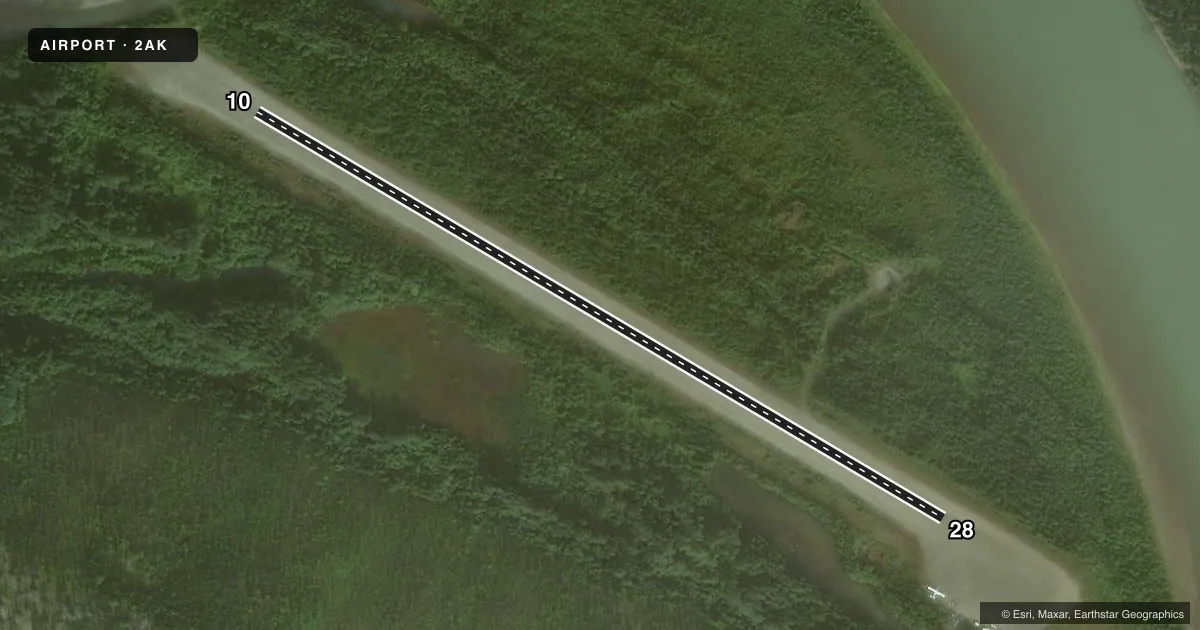
Airport sketch
Runways drawn to scale from FAA survey coordinates, rendered over satellite imagery. Not for navigation.
Approaches & charts
Services on the field
Fuel grades, oxygen, maintenance, ramp storage and lighting — as declared to the FAA by the airport operator.
Fuel & services
- Fuel
- Not available
Ramp & ground
- Transient storage
- Not published
- Landing fee
- No fee published
- Wind indicator
- Yes
- Segmented circle
- No
Fuel & FBOs
Cheapest 100LL and Jet A on the field and nearby. Always confirm with the FBO before taxi.
Airport notes
Surface conditions, obstructions, local procedures, lighting outages and other notes published with each FAA cycle.
General notes
- NW RY END FLOODS DURING BREAK-UP.
- RY COND NOT MONITORED; RECOMMEND VISUAL INSPECTION PRIOR TO USING.
- RY 10/28 MKD WITH ORANGE 3 FT CONES.
- WX CAMERA AVBL ON INTERNET AT HTTPS://WEATHERCAMS.FAA.GOV
- RWY 10/28 IRREGULAR SFC LOOSE ROCKS UP TO 12IN MAY BE PRESENT LENGTH OF RUNWAY.
Other notes
- WINDSOCK UNRELIABLE.
VFR map & nearby airports
VFR sectional. Tap any ICAO chip to open that airport.
Key facts · 2AK
Answer card- ICAO
- 2AK
- Name
- LIME VILLAGE
- Location
- LIME VILLAGE, ALASKA
- Elevation
- 545 ft MSL
- Traffic pattern altitude
- 1,545 ft MSL (1,000 AGL)
- Control tower
- Non-towered (use CTAF)
- Total runways
- 1
- Longest runway
- 10/28 · 1,500 ft
- Published ILS approaches
- 0
- Published frequencies
- 1
- Magnetic variation
- 22°
- Current flight rules
- MVFR
- Current wind
- 000° at 0 kt
- Favored runway now
- –
Lime Village Airport sits in Lime Village, Alaska. Field elevation is 545 ft MSL. The airport has one runway. Runway 10/28 is 1,500 ft long with a gravel-dirt surface. The runway headings are 121° and 301° magnetic. There is no control tower. CTAF is 122.9.
No ILS approaches are published here. Pattern altitude is not published. Use the standard 1,000 ft AGL pattern unless local guidance says otherwise. That puts the traffic pattern at about 1,545 ft MSL. Check the current FAA Chart Supplement before you go.
There are no on-field FBOs listed for 2AK. Plan to be self-sufficient. Published remarks matter here. The runway has loose rocks that may be present along its length. The northwest end can flood during break-up. The windsock is unreliable. The runway is marked with orange 3-foot cones. Runway condition is not monitored, so a visual inspection before use is a good idea. A weather camera is available online for a current look at the field. This is a small Alaska strip with a rough surface and limited published services. Treat it like a remote backcountry arrival and verify current conditions before departure.