METAR & TAF PAFL
PAFL does not publish a METAR.
Showing the nearest reporting station: PAFS (NIKOLAI) · 35.7 NM away. Conditions at PAFL may differ.
METAR · PAFS
Observed 11:01Z
PAFS 271101Z AUTO 00000KT 3SM RA BR FEW055 OVC080 14/14 A2978
- Wind
- 000° @ 0 kt
- Visibility
- 3 SM
- Temp / Dew
- 14°C / 14°C
- Altimeter
- 29.78 inHg
- Clouds
- OVC
- Density alt
- 1,523 ft
- Ceiling
- 8,000 ft AGL
- Rules
- MVFR
Airport info & contacts
Manager on record, flight service, ARTCC, attendance schedule and pattern altitude — published by the FAA and refreshed every 28 days.
Location
- From city
- 1 NM S
- VFR sectional
- MC GRATH
- ARTCC
- ZAN · ANCHORAGE
- NOTAM facility
- ENA (NOTAM-D)
Airport manager
- Name
- CATHY FROST
- Phone
- 907-783-2636
- Address
- BOX 1149, GIRDWOOD AK 99587
Flight service · Hours
- FSS ENA
- KENAI907-283-72111-866-864-1737
- Attendance
- Unattended
Frequencies
Tap any row to copy the frequency to your clipboard.
Runways & pattern
Full pagePattern entry · RWY 13
LEFT TRAFFICRunway end performance
| End | TORA | TODA | ASDA | LDA | VGSI | Approach lights | Obstruction |
|---|---|---|---|---|---|---|---|
| 13 | — | — | — | — | — | — | 30', tree, 0' from thr, 0' R of cntrln, slope 0 |
| 31 | — | — | — | — | — | — | 35', tree, 0' from thr, 0' R of cntrln, slope 0 |
Declared distances in feet. TORA = takeoff run available, TODA = takeoff distance, ASDA = accelerate-stop, LDA = landing distance.
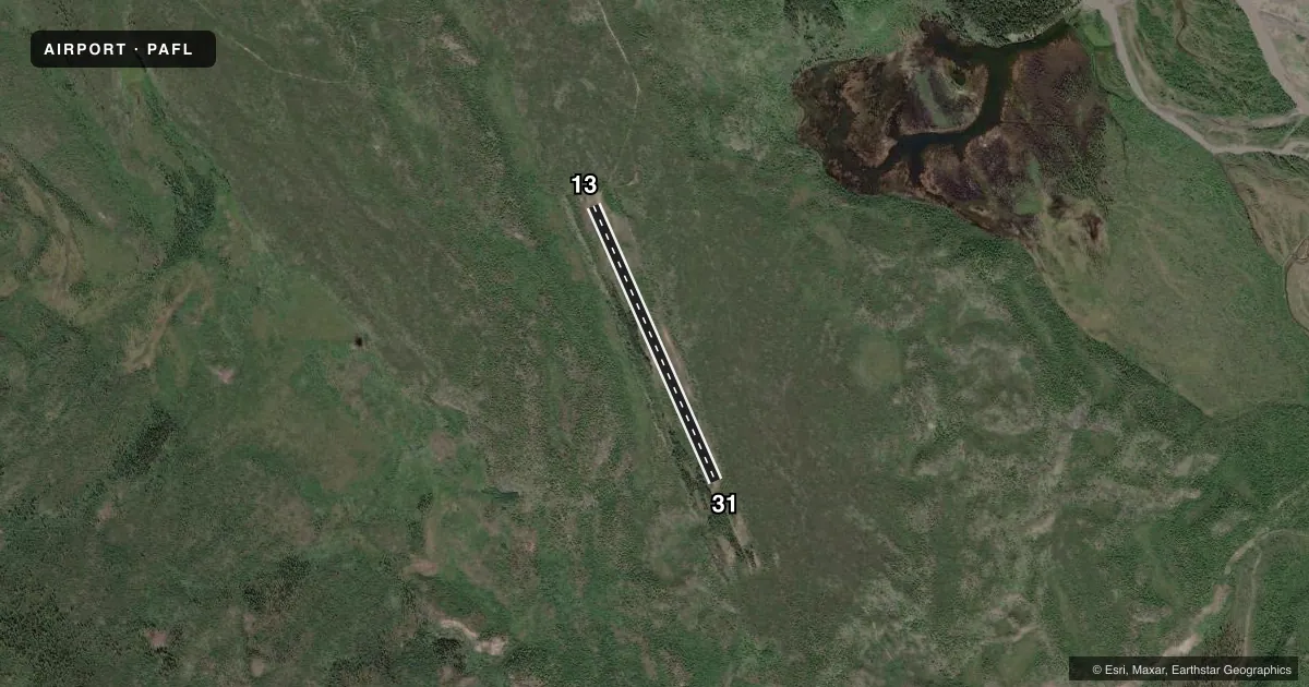
Airport sketch
Runways drawn to scale from FAA survey coordinates, rendered over satellite imagery. Not for navigation.
Approaches & charts
Services on the field
Fuel grades, oxygen, maintenance, ramp storage and lighting — as declared to the FAA by the airport operator.
Fuel & services
- Fuel
- Not available
Ramp & ground
- Transient storage
- Not published
- Landing fee
- No fee published
- Customs
- Not available
Fuel & FBOs
Cheapest 100LL and Jet A on the field and nearby. Always confirm with the FBO before taxi.
Airport notes
Surface conditions, obstructions, local procedures, lighting outages and other notes published with each FAA cycle.
General notes
- WILDLIFE ON & INVOF RWY.
- CTN: BURN AREA; BURNT TREES & SNAGS DFCLT TO SEE ON OR NEAR RWY.
Runway surface & condition
- 13/31NOT MNTND; 8 FT TREES & BRUSH BOTH SIDES WI 6 FT OF CNTRLN.
Other notes
- 13/31IREG; 10 IN LOOSE ROCK; SFC UNEVEN ENTIRE LEN.
VFR map & nearby airports
VFR sectional. Tap any ICAO chip to open that airport.
Key facts · PAFL
Answer card- ICAO
- PAFL
- Name
- TIN CREEK
- Location
- FAREWELL LAKE, ALASKA
- Elevation
- 1,185 ft MSL
- Traffic pattern altitude
- 2,185 ft MSL (1,000 AGL)
- Control tower
- Non-towered (use CTAF)
- Total runways
- 1
- Longest runway
- 13/31 · 2,000 ft
- Published ILS approaches
- 0
- Published frequencies
- 1
- Magnetic variation
- 24°
- Current flight rules
- MVFR
- Current wind
- 000° at 0 kt
- Favored runway now
- –
Tin Creek Airport (PAFL) sits at Farewell Lake in Alaska. Field elevation is 1,185 ft MSL. The airport has one runway. Runway 13/31 is 2,000 ft long and gravel. There is no control tower. CTAF is 122.9. No ILS approaches are published here.
Pattern altitude is not published. Use the standard 1,000 ft AGL for light piston operations unless the current FAA Chart Supplement says otherwise. That puts the traffic pattern at about 2,185 ft MSL. The field has no on-field FBOs listed, so plan fuel and services with the airport operator or the FBO directly before you go.
This is a rough field. The published remarks call out wildlife on and near the runway. They also note an irregular surface with about 10 inches of loose rock along the full length of 13/31. The runway is not maintained. Trees and brush are close to the centerline on both sides. There is also a burn area with burnt trees and snags that can be hard to see near the runway. Expect a very careful look on arrival and departure. Use the current FAA Chart Supplement for the latest operational notes before you fly in.