METAR & TAF 2K5
2K5 does not publish a METAR.
Showing the nearest reporting station: PAFS (NIKOLAI) · 36.2 NM away. Conditions at 2K5 may differ.
METAR · PAFS
Observed 18:01Z
PAFS 271801Z AUTO 22006KT 10SM OVC008 14/14 A2978
- Wind
- 220° @ 6 kt
- Visibility
- 10 SM
- Temp / Dew
- 14°C / 14°C
- Altimeter
- 29.78 inHg
- Clouds
- OVC
- Density alt
- 860 ft
- Ceiling
- 800 ft AGL
- Rules
- IFR
Airport info & contacts
Manager on record, flight service, ARTCC, attendance schedule and pattern altitude — published by the FAA and refreshed every 28 days.
Location
- From city
- 0 NM S
- VFR sectional
- MC GRATH
- ARTCC
- ZAN · ANCHORAGE
- NOTAM facility
- ENA (NOTAM-D)
Airport manager
Flight service · Hours
- FSS ENA
- KENAI907-283-72111-866-864-1737
- Attendance
- Unattended
Frequencies
Tap any row to copy the frequency to your clipboard.
Runways & pattern
Full pagePattern entry · RWY 20
LEFT TRAFFICRunway end performance
| End | TORA | TODA | ASDA | LDA | VGSI | Approach lights | Obstruction |
|---|---|---|---|---|---|---|---|
| 02 | — | — | — | — | — | — | 50', trees, 0' from thr, 80' R of cntrln, slope 0 |
| 20 | — | — | — | — | — | — | 50', trees, 0' from thr, 80' R of cntrln, slope 0 |
Declared distances in feet. TORA = takeoff run available, TODA = takeoff distance, ASDA = accelerate-stop, LDA = landing distance.
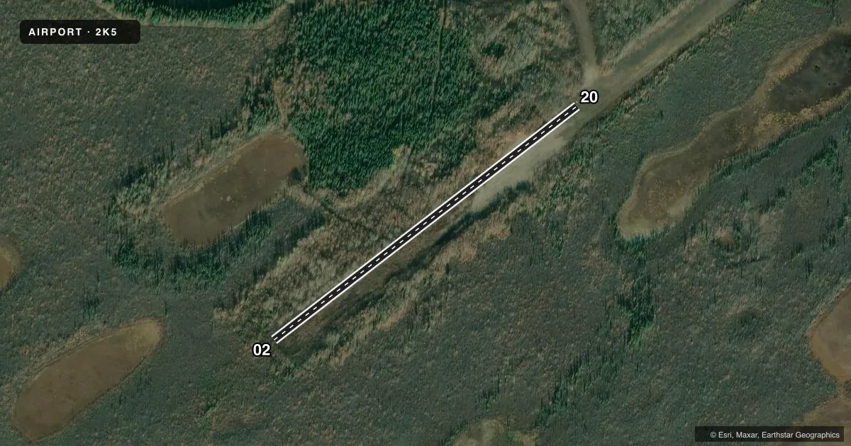
Airport sketch
Runways drawn to scale from FAA survey coordinates, rendered over satellite imagery. Not for navigation.
Approaches & charts
Services on the field
Fuel grades, oxygen, maintenance, ramp storage and lighting — as declared to the FAA by the airport operator.
Fuel & services
- Fuel
- Not available
Ramp & ground
- Transient storage
- Not published
- Landing fee
- No fee published
- Customs
- Not available
- Wind indicator
- No
- Segmented circle
- No
Fuel & FBOs
Cheapest 100LL and Jet A on the field and nearby. Always confirm with the FBO before taxi.
Airport notes
Surface conditions, obstructions, local procedures, lighting outages and other notes published with each FAA cycle.
General notes
- RWY COND UNMNT; RCMD VISUAL INSP BFR USE. BLOWG DUST ALG RWY.
- WILDLIFE ON & INVOF RWY.
Runway surface & condition
- 02/20150 FT SW END UNUSBL DUE TO BRUSH, TREES, DIPS, HUMPS & +2 FT DUNES. 900 FT NE END SOFT.
Other notes
- ESTABD PRIOR TO 1959.
- 02/20IREG; RUTTED. SOFT & UNSTBL DUE TO SHIFTING SND.
- 02/20VRBL BTN TURF, DIRT & SAND.
VFR map & nearby airports
VFR sectional. Tap any ICAO chip to open that airport.
Key facts · 2K5
Answer card- ICAO
- 2K5
- Name
- TELIDA
- Location
- TELIDA, ALASKA
- Elevation
- 650 ft MSL
- Traffic pattern altitude
- 1,650 ft MSL (1,000 AGL)
- Control tower
- Non-towered (use CTAF)
- Total runways
- 1
- Longest runway
- 02/20 · 1,900 ft
- Published ILS approaches
- 0
- Published frequencies
- 1
- Magnetic variation
- 24°
- Current flight rules
- IFR
- Current wind
- 220° at 6 kt
- Favored runway now
- RWY 20
Telida Airport (2K5) sits in Telida, Alaska. Field elevation is 650 ft MSL. The airport has one runway, 02/20 and the longest runway is 1,900 ft. There is no control tower. CTAF is 122.9. No ILS approaches are published here.
The pattern altitude is not published. Use the standard 1,000 ft AGL pattern unless the current Chart Supplement says otherwise. The runway surface varies between turf, dirt and sand. Published remarks say the southwest 150 ft of Runway 02/20 is unusable because of brush, trees, dips, humps and 2 ft dunes. The northeast 900 ft is soft. The surface is irregular and rutted. It is also soft and unstable due to shifting sand. A visual inspection before landing is a good idea. Dust can blow along the runway. Wildlife is also present on and near the runway.
There are no on-field FBOs listed. Check with the airport operator or the FBO directly by phone before you go if you need local services. This is a remote strip with a short, unimproved runway. Plan for soft-field technique, careful performance planning. Do a close look at the surface before committing.