METAR & TAF 01A
01A does not publish a METAR.
Showing the nearest reporting station: PAMH (MINCHUMINA) · 56.8 NM away. Conditions at 01A may differ.
METAR · PAMH
Observed 11:56Z
PAMH 271156Z AUTO VRB04KT 10SM CLR 16/12 A2973 RMK AO2 SLP910 T01610122 10211 20161 50004 $
- Wind
- VAR @ 4 kt
- Visibility
- 10 SM
- Temp / Dew
- 16°C / 12°C
- Altimeter
- 29.73 inHg
- Clouds
- CLR
- Density alt
- 2,886 ft
- Ceiling
- Unlimited
- Rules
- VFR
Airport info & contacts
Manager on record, flight service, ARTCC, attendance schedule and pattern altitude — published by the FAA and refreshed every 28 days.
Location
- From city
- 10 NM SW
- VFR sectional
- MC GRATH
- ARTCC
- ZAN · ANCHORAGE
- NOTAM facility
- FAI (NOTAM-D)
Airport manager
- Name
- STATE OF ALASKA, DNR, DMLW
- Phone
- 907-269-8400
- Address
- 550 W 7TH AVE STE 900C, ANCHORAGE AK 99501-3577
Flight service · Hours
- FSS FAI
- FAIRBANKS907-474-07881-866-248-6516
- Attendance
- MAY-SEPT · DALGT ONLY
Frequencies
Tap any row to copy the frequency to your clipboard.
Runways & pattern
Full pagePattern entry · RWY 05
LEFT TRAFFICRunway end performance
| End | TORA | TODA | ASDA | LDA | VGSI | Approach lights | Obstruction |
|---|---|---|---|---|---|---|---|
| 05 | — | — | — | — | — | — | 12', brush, 0' from thr, 50' R of cntrln, slope 0 |
| 23 | — | — | — | — | — | — | 45', trees, 0' from thr, 50' R of cntrln, slope 0 |
Declared distances in feet. TORA = takeoff run available, TODA = takeoff distance, ASDA = accelerate-stop, LDA = landing distance.
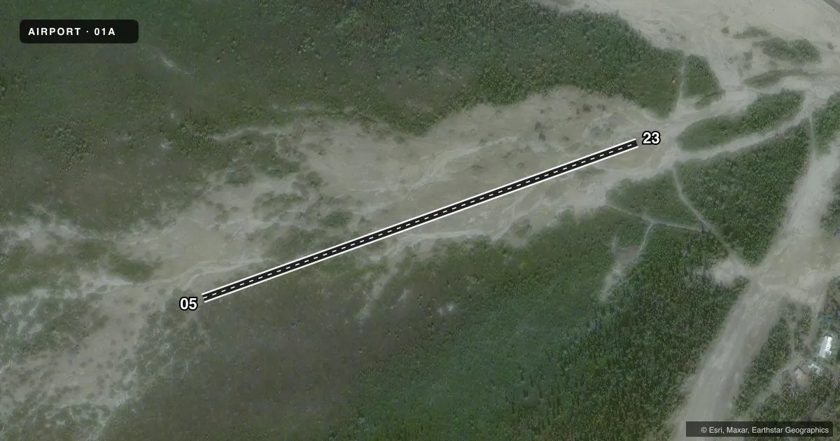
Airport sketch
Runways drawn to scale from FAA survey coordinates, rendered over satellite imagery. Not for navigation.
Approaches & charts
Services on the field
Fuel grades, oxygen, maintenance, ramp storage and lighting — as declared to the FAA by the airport operator.
Fuel & services
- Fuel
- Not available
Ramp & ground
- Transient storage
- Not published
- Landing fee
- No fee published
- Customs
- Not available
- Wind indicator
- Yes
- Segmented circle
- No
Fuel & FBOs
Cheapest 100LL and Jet A on the field and nearby. Always confirm with the FBO before taxi.
Airport notes
Surface conditions, obstructions, local procedures, lighting outages and other notes published with each FAA cycle.
General notes
- ALERT: RIVER CHANGES COURSE & MAY FLOOD OR DAMAGE STRIP.
Runway surface & condition
- 05/23NOT MNTND.
Approach & departure obstructions
- 23APCH HAS 42 FT TREES EACH SIDE WITH CUT OUTS FOR WING WIDTH.
Other notes
- OWNERDIVISION OF LAND (SCRO).
- 05/23SOFT SAND WITH RIVER ROCK TO 5 IN DIAM.
VFR map & nearby airports
VFR sectional. Tap any ICAO chip to open that airport.
Key facts · 01A
Answer card- ICAO
- 01A
- Name
- PURKEYPILE
- Location
- PURKEYPILE, ALASKA
- Elevation
- 2,041 ft MSL
- Traffic pattern altitude
- 3,041 ft MSL (1,000 AGL)
- Control tower
- Non-towered (use CTAF)
- Total runways
- 1
- Longest runway
- 05/23 · 1,176 ft
- Published ILS approaches
- 0
- Published frequencies
- 1
- Magnetic variation
- 24°
- Current flight rules
- VFR
- Current wind
- 000° at 4 kt
- Favored runway now
- RWY 05
PURKEYPILE (01A) is in Purkeypile, Alaska. The field elevation is 2,041 ft MSL. It has one runway. Runway 05/23 is 1,176 ft long and gravel surfaced. This is a non-towered airport. CTAF is 122.9. No ILS approaches are published.
The pattern altitude is not published. Use 1,000 ft AGL as the standard light piston pattern reference unless the current FAA Chart Supplement says otherwise. At this elevation, expect a higher density altitude than you would see at sea level. That matters on a short strip like this.
The published remarks matter here. The surface is soft sand with river rock up to 5 inches in diameter. The runway is not maintained. The river can change course and may flood or damage the strip. Runway 23 also has 42-foot trees on both sides with cutouts for wing width. There are no on-field FBOs listed. Check the current FAA Chart Supplement and contact the airport operator before you go. This is a place for a careful performance check. It also calls for a conservative go or no-go decision. Give the field a close look before landing.