METAR & TAF PASW
PASW does not publish a METAR.
Showing the nearest reporting station: PATK (TALKEETNA) · 37.6 NM away. Conditions at PASW may differ.
METAR · PATK
Observed 14:27Z
PATK 271427Z AUTO 21003KT 6SM -RA BR FEW006 OVC010 12/11 A2983 RMK AO2 P0002 T01220111 TSNO $
- Wind
- 210° @ 3 kt
- Visibility
- 6 SM
- Temp / Dew
- 12°C / 11°C
- Altimeter
- 29.83 inHg
- Clouds
- OVC
- Density alt
- -65 ft
- Ceiling
- 1,000 ft AGL
- Rules
- MVFR
Airport info & contacts
Manager on record, flight service, ARTCC, attendance schedule and pattern altitude — published by the FAA and refreshed every 28 days.
Location
- From city
- 1 NM NE
- VFR sectional
- ANCHORAGE
- ARTCC
- ZAN · ANCHORAGE
- NOTAM facility
- SKW (NOTAM-D)
Airport manager
- Name
- KYLER HYLTON
- Phone
- 907-745-2159
- Address
- 289 INNER SPRING LOOP, PALMER AK 99645
Flight service · Hours
- FSS ENA
- KENAI907-283-72111-866-864-1737
- Attendance
- Unattended
Frequencies
Tap any row to copy the frequency to your clipboard.
Runways & pattern
Full pagePattern entry · RWY 28
LEFT TRAFFICRunway end performance
| End | TORA | TODA | ASDA | LDA | VGSI | Approach lights | Obstruction |
|---|---|---|---|---|---|---|---|
| 10 | — | — | — | — | — | — | 9', brush, 0' from thr, 87' R of cntrln, slope 0 |
| 28 | — | — | — | — | — | — | 8', brush, 0' from thr, 89' R of cntrln, slope 0 |
Declared distances in feet. TORA = takeoff run available, TODA = takeoff distance, ASDA = accelerate-stop, LDA = landing distance.
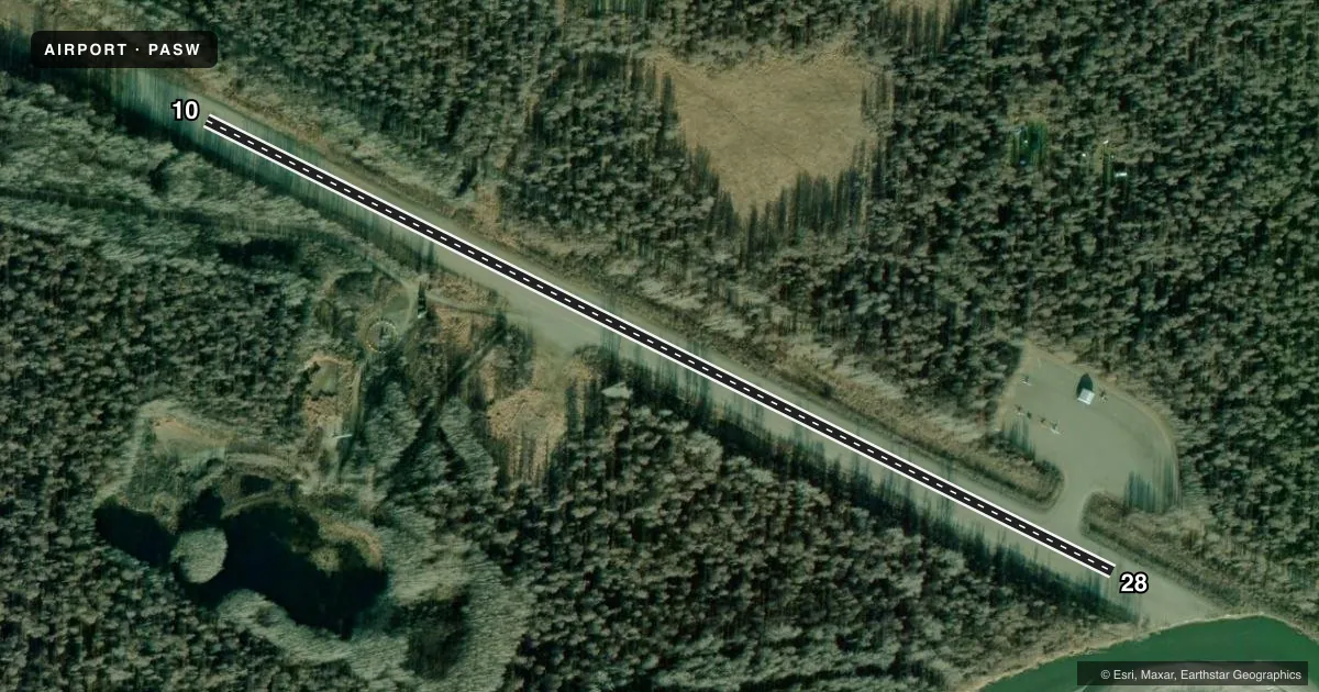
Airport sketch
Runways drawn to scale from FAA survey coordinates, rendered over satellite imagery. Not for navigation.
Approaches & charts
Services on the field
Fuel grades, oxygen, maintenance, ramp storage and lighting — as declared to the FAA by the airport operator.
Fuel & services
- Fuel
- Not available
Ramp & ground
- Transient storage
- Not published
- Landing fee
- No fee published
- Customs
- Not available
- Lighting schedule
- SEE RMK
- Beacon schedule
- SEE RMK
- Beacon
- White / Green (civil land)(WG)
- Wind indicator
- Lighted
- Segmented circle
- Yes
Fuel & FBOs
Cheapest 100LL and Jet A on the field and nearby. Always confirm with the FBO before taxi.
Airport notes
Surface conditions, obstructions, local procedures, lighting outages and other notes published with each FAA cycle.
General notes
- TWO 100 FT TWRS 1.5 NM W. SOFT DURG SPRING.
- RWY COND UNMNT; RCMD VISUAL INSP BFR LNDG.
- WX CAMERA AVBL ON INTERNET AT HTTPS://WEATHERCAMS.FAA.GOV.
Lighting notes
- ACTVT ROTG BCN - CTAF.
- ACTVT MIRL RWY 10/28; WINDSOCK - CTAF.
Approach & departure obstructions
- 10ATV ROAD XS RWY 900 FT FM THR.
- 10REFLECTIVE CONES; THRS REFLECTIVE PANELS.
- 28REFLECTIVE CONES; THRS REFLECTIVE PANELS.
- 10200 FT PATH CUT THRU TREES APCH END.
VFR map & nearby airports
VFR sectional. Tap any ICAO chip to open that airport.
Key facts · PASW
Answer card- ICAO
- PASW
- Name
- SKWENTNA
- Location
- SKWENTNA, ALASKA
- Elevation
- 148 ft MSL
- Traffic pattern altitude
- 1,148 ft MSL (1,000 AGL)
- Control tower
- Non-towered (use CTAF)
- Total runways
- 1
- Longest runway
- 10/28 · 3,400 ft
- Published ILS approaches
- 0
- Published frequencies
- 1
- Magnetic variation
- 25°
- Current flight rules
- MVFR
- Current wind
- 210° at 3 kt
- Favored runway now
- RWY 28
Skwentna Airport (PASW) is in Skwentna, Alaska. The field elevation is 148 ft MSL. It has one runway, 10/28, which is 3,400 ft long and gravel. The airport is not towered. CTAF is 122.9.
No ILS approaches are published here. The pattern altitude is not published, so use the standard 1,000 ft AGL for light piston operations unless the current Chart Supplement says otherwise. The runway headings are magnetic. Runway 10/28 is equipped with medium intensity runway lights. The rotating beacon is activated on CTAF.
There are no on-field FBOs listed in the facts. Plan on confirming services directly with the airport operator or by calling the field before arrival. Published remarks note reflective cones and threshold panels on both runway ends. There is also a 200-foot path cut through trees at the approach end of runway 10. An ATV road crosses the runway 900 ft from the threshold of runway 10. Runway condition is unmonitored, so a visual inspection before landing is a good idea. Two 100-foot towers sit 1.5 NM west. They are noted as soft in spring. For current weather, a FAA weather camera is available online. This is a gravel strip in Alaska, so expect seasonal surface and braking changes. Check the current Chart Supplement before you go.