METAR & TAF 2X2
2X2 does not publish a METAR.
Showing the nearest reporting station: PAWS (WASILLA) · 18.0 NM away. Conditions at 2X2 may differ.
METAR · PAWS
Observed 02:56Z
PAWS 280256Z AUTO 10003KT 10SM OVC049 13/12 A2995 RMK AO2 RAE45 SLP115 P0000 60009 T01280117 51003 $
- Wind
- 100° @ 3 kt
- Visibility
- 10 SM
- Temp / Dew
- 13°C / 12°C
- Altimeter
- 29.95 inHg
- Clouds
- OVC
- Density alt
- -29 ft
- Ceiling
- 4,900 ft AGL
- Rules
- VFR
Airport info & contacts
Manager on record, flight service, ARTCC, attendance schedule and pattern altitude — published by the FAA and refreshed every 28 days.
Location
- From city
- 1 NM NW
- VFR sectional
- ANCHORAGE
- ARTCC
- ZAN · ANCHORAGE
- NOTAM facility
- ENA (NOTAM-D)
Airport manager
- Name
- RAY ADAMS
- Phone
- 907-495-6286
- Address
- ST OF AK -- DOTPF WILLOW STATION, PO BOX 889, WILLOW AK 99688
Flight service · Hours
- FSS ENA
- KENAI907-283-72111-866-864-1737
- Attendance
- Unattended
Frequencies
Tap any row to copy the frequency to your clipboard.
Runways & pattern
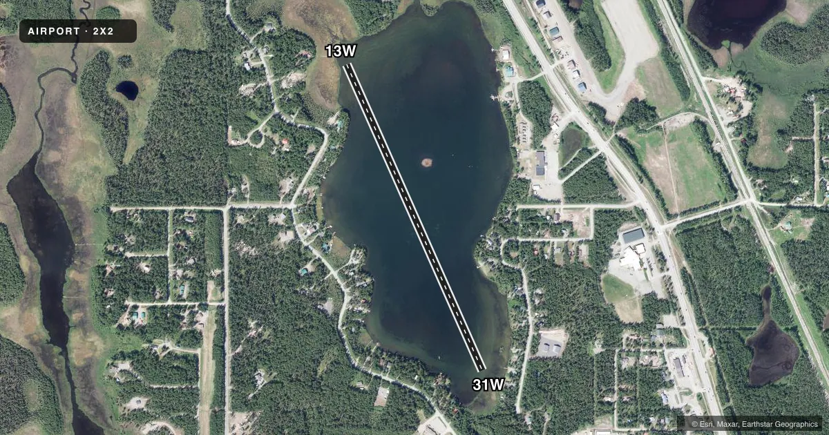
Full pagePattern entry · RWY 13W
LEFT TRAFFICAirport sketch
Runways drawn to scale from FAA survey coordinates, rendered over satellite imagery. Not for navigation.
Approaches & charts
Services on the field
Fuel grades, oxygen, maintenance, ramp storage and lighting — as declared to the FAA by the airport operator.
Fuel & services
- Fuel
- Not available
- Power plant repair
- Major
- Other services
- CHTR
Ramp & ground
- Transient storage
- Tie-down
- Wind indicator
- Yes
Fuel & FBOs
Cheapest 100LL and Jet A on the field and nearby. Always confirm with the FBO before taxi.
Airport notes
Surface conditions, obstructions, local procedures, lighting outages and other notes published with each FAA cycle.
General notes
- ACFT RUN-UP AREA AT THE NE END OF THE LAKE IS MARKED BY BUOYS SEASONALLY.
- A BUOY HAS BEEN PLACED APRXLY 200 FT FROM THE MOST SOUTHERN POINT OF LAND ON THE SOUTHEAST END OF THE LAKE.
- ACFT OPERS ARE NOT ALLOWED INSIDE THE 200 FT MARKER UNLESS TAXING TO OR FROM THE SHORE, OR TAXIING TO THE ACFT RUN-UP AREA.
- PILOTS SHOULD BE AWARE OF WATERCRAFT AND RECREATIONAL ACTIVITIES ON THE LAKE. A VISUAL INSPECTION PRIOR TO LANDING IS RECOMMENDED. BUOYS ARE REMOVED FROM LAKE PRIOR TO FREEZE-UP AND REPLACED WHEN LAKE THAWS.
- IT IS RCMDD THAT ALL ACFT TKOF TOWARD THE SOUTH, WX CONDITIONS PERMITTING.
- NO EAST/WEST TKOFS OR LANDINGS ARE PERMITTED.
- WX CAMERA AVBL ON INTERNET AT HTTPS://WEATHERCAMS.FAA.GOV
- NO WINTER MAINTENANCE BE ALERT DURING LNDG/TKOF.
- NO PUB DOCK AVBL.
- GRVL PUB RAMP LCTD ON NE SHORE OF LAKE.
- NO PUB PRKG AVAIL.
Other notes
- WIND INDICATOR AVBL AT WILLOW ARPT ACROSS THE ROAD.
VFR map & nearby airports
VFR sectional. Tap any ICAO chip to open that airport.
Key facts · 2X2
Answer card- ICAO
- 2X2
- Name
- WILLOW SPB
- Location
- WILLOW, ALASKA
- Elevation
- 200 ft MSL
- Traffic pattern altitude
- 1,200 ft MSL (1,000 AGL)
- Control tower
- Non-towered (use CTAF)
- Total runways
- 1
- Longest runway
- 13W/31W · 3,600 ft
- Published ILS approaches
- 0
- Published frequencies
- 2
- Magnetic variation
- –
- Current flight rules
- VFR
- Current wind
- 100° at 3 kt
- Favored runway now
- RWY 13W
Willow SPB sits in Willow, Alaska. Field elevation is 200 ft MSL. The airport has one water runway, 13W/31W, at 3,600 ft. No control tower is published. No ILS approaches are published. Pattern altitude is not published, so verify the current Chart Supplement before you go. The field uses CTAF and UNICOM 122.8.
This is a lake operation, so plan for water traffic and recreational use on the lake. A visual inspection before landing is recommended. Buoys are seasonal. One buoy is placed about 200 feet from the most southern point of land on the southeast end of the lake. No east or west takeoffs or landings are permitted. The published recommendation is to depart to the south when weather allows. That matters here because the lake has specific operating limits near the shoreline and a marked run-up area at the northeast end.
There is no public dock and no public parking. A gravel public ramp is on the northeast shore. No winter maintenance is provided. A wind indicator is available at Willow Airport across the road. There are no on-field FBOs listed, so contact the airport operator or the FBO directly by phone before arrival if you need current services.