METAR & TAF PATK
Current METAR
Observed 22:11Z
PATK 272211Z 20006KT 9SM -RA SCT014 BKN019 OVC028 13/11 A2989 RMK AO2 P0002 T01280111 $
- Wind
- 200° @ 6 kt
- Visibility
- 9 SM
- Temp / Dew
- 13°C / 11°C
- Altimeter
- 29.89 inHg
- Clouds
- OVC
- Density alt
- 250 ft
- Ceiling
- 1,900 ft AGL
- Rules
- MVFR
Airport info & contacts
Manager on record, flight service, ARTCC, attendance schedule and pattern altitude — published by the FAA and refreshed every 28 days.
Location
- From city
- 1 NM E
- VFR sectional
- ANCHORAGE
- ARTCC
- ZAN · ANCHORAGE
- NOTAM facility
- TKA (NOTAM-D)
Airport manager
- Name
- CHRIS DREWS
- Phone
- 907-733-2278
- Address
- PO BOX 610, TALKEETNA AK 99676
Flight service · Hours
- FSS TKA
- TALKEETNA907-733-22771-800-478-7150
- Attendance
- APR-NOV · MON-THU · 1500-0130
- DEC-MAR · SUN-SAT · 1500-0130
Frequencies
Tap any row to copy the frequency to your clipboard.
Runways & pattern
Full pagePattern entry · RWY 19
RIGHT TRAFFICRunway end performance
| End | TORA | TODA | ASDA | LDA | VGSI | Approach lights | Obstruction |
|---|---|---|---|---|---|---|---|
| 01 | — | — | — | — | VASI 4-box right(3°) | — | 47', trees, 995' from thr, 340' R of cntrln, slope 16 |
| 19 | — | — | — | — | VASI 4-box left(3°) | — | — |
Declared distances in feet. TORA = takeoff run available, TODA = takeoff distance, ASDA = accelerate-stop, LDA = landing distance.
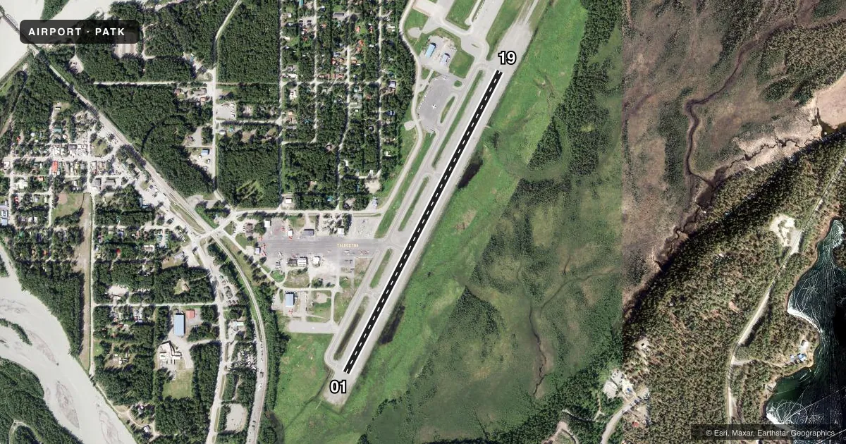
Airport sketch
Runways drawn to scale from FAA survey coordinates, rendered over satellite imagery. Not for navigation.
Approaches & charts
Services on the field
Fuel grades, oxygen, maintenance, ramp storage and lighting — as declared to the FAA by the airport operator.
Fuel & services
- Fuel
- 100LLAA+
- Airframe repair
- Major
- Power plant repair
- Major
- Other services
- CARGO,CHTR
Ramp & ground
- Transient storage
- Tie-down
- Landing fee
- No fee published
- Customs
- Not available
- Lighting schedule
- SEE RMK
- Beacon schedule
- SS-SR
- Beacon
- White / Green (civil land)(WG)
- Wind indicator
- Lighted
- Segmented circle
- Yes
Fuel & FBOs
Cheapest 100LL and Jet A on the field and nearby. Always confirm with the FBO before taxi.
Airport notes
Surface conditions, obstructions, local procedures, lighting outages and other notes published with each FAA cycle.
General notes
- HEL OPS N RAMP. HEL OPS TO & FM HEL RAMPS AVOID RAMP OTFC & RMN CLEAR OF COMM RAMP & GA PRKG.
- RWY COND UNMNT; RCMD VISUAL INSP BFR USE.
- SBP OPS 3/4 MI SE; OPS TO & FM CHRISTIANSEN LAKE RMN E OF LAKE.
- ALL OPS MNT CTAF.
- TFC PAT INFO: SEE C NOTICE.
- TSNT PRKG AVBL.
- WALKING ACTV TWY/APRONS NA.
- WX CAMERA AVBL ON INTERNET AT HTTPS://WEATHERCAMS.FAA.GOV.
- COLD TEMPERATURE AIRPORT. ALTITUDE CORRECTION REQUIRED AT OR BELOW -28C.
- FUEL AVBL H24. AFT HR PPR.
Lighting notes
- ACTVT MIRL RWY 01/19 - CTAF. VASI RWY 01 & 19 OPR CONSLY.
Fuel notes
- AOFF ARPT; MON-FRI 1600-0200Z; PPR - 907-733-2620.
Runway surface & condition
- 01/19CLSD OVR 12500 LB - AMGR.
VFR map & nearby airports
VFR sectional. Tap any ICAO chip to open that airport.
Key facts · PATK
Answer card- ICAO
- PATK
- Name
- TALKEETNA
- Location
- TALKEETNA, ALASKA
- Elevation
- 365 ft MSL
- Traffic pattern altitude
- 1,365 ft MSL (1,000 AGL)
- Control tower
- Non-towered (use CTAF)
- Total runways
- 1
- Longest runway
- 01/19 · 3,500 ft
- Published ILS approaches
- 0
- Published frequencies
- 2
- Magnetic variation
- 16°
- Current flight rules
- MVFR
- Current wind
- 200° at 6 kt
- Favored runway now
- RWY 19
Talkeetna Airport sits in Talkeetna, Alaska at 365 ft MSL. It has one runway. Runway 01/19 is 3,500 ft long with a concrete surface. There is no control tower. Traffic pattern information is published in the C notice. Pattern altitude is not published, so a light piston pilot should verify the current pattern details before arrival. No ILS approaches are published here.
The field has two on-field FBOs. Crowley Aviation Fuels carries 100LL and Jet A. Sheldon Air Service carries 100LL. Fuel is available 24 hours a day. After-hours use needs prior permission. This is a cold temperature airport, so altitude correction is required at or below minus 28 degrees Celsius. Runway 01/19 is closed to aircraft over 12,500 pounds. Contact the airport manager if that matters to your flight.
A few operational items matter here. Runway condition is unmonitored, so a visual check before use is smart. There is an obstruction near runway 01 that exceeds a 45 degree slope. Medium intensity runway lights are activated on CTAF. The VASI for runways 01 and 19 operate continuously. Keep all operations on the common traffic advisory frequency. Walking on taxiways and aprons is not authorized.