METAR & TAF PAWS
Current METAR
Observed 02:08Z
PAWS 280208Z AUTO 00000KT 10SM SCT005 OVC049 13/12 A2995 RMK AO2 RAE08 P0000 $
- Wind
- 000° @ 0 kt
- Visibility
- 10 SM
- Temp / Dew
- 13°C / 12°C
- Altimeter
- 29.95 inHg
- Clouds
- OVC
- Density alt
- 161 ft
- Ceiling
- 4,900 ft AGL
- Rules
- VFR
Airport info & contacts
Manager on record, flight service, ARTCC, attendance schedule and pattern altitude — published by the FAA and refreshed every 28 days.
Location
- From city
- 3 NM W
- VFR sectional
- ANCHORAGE
- ARTCC
- ZAN · ANCHORAGE
- NOTAM facility
- IYS (NOTAM-D)
Airport manager
- Name
- ERICH SCHAAL
- Phone
- 907-373-9018
- Address
- CITY OF WASILLA, 290 E HERNING AVE, WASILLA AK 99654
Flight service · Hours
- FSS ENA
- KENAI907-283-72111-866-864-1737
- Attendance
- Unattended
Frequencies
Tap any row to copy the frequency to your clipboard.
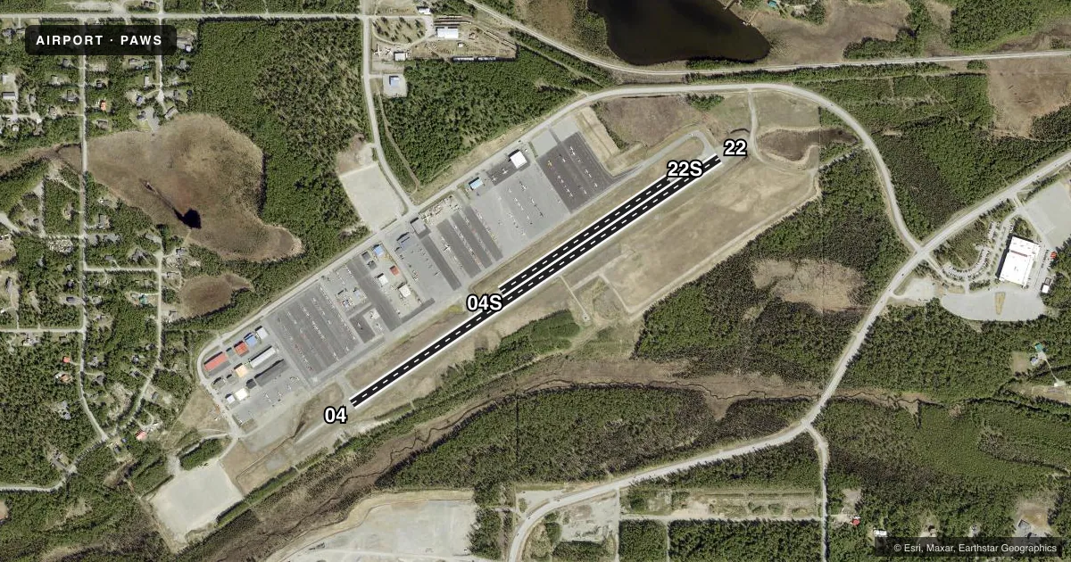
Runways & pattern
Full pagePattern entry · RWY 04
RIGHT TRAFFIC| Runway | Heading (°M) | Length | Surface | Traffic |
|---|---|---|---|---|
| 04/22 | 38° / 218° | 3,700 ft | ASPH | 04 R |
| 04S/22S | 38° / 218° | 1,690 ft | TURF-GRVL | Standard L |
Runway end performance
| End | TORA | TODA | ASDA | LDA | VGSI | Approach lights | Obstruction |
|---|---|---|---|---|---|---|---|
| 04 | — | — | — | — | PAPI 4-box right(3°) | — | 30', trees, 201' from thr, 115' R of cntrln, slope 0 |
| 22 | — | — | — | — | — | — | 14', trees, 260' from thr, 120' R of cntrln, slope 4 |
| 04S | — | — | — | — | — | — | 2', hill, 0' from thr, 65' R of cntrln, slope 0 |
Declared distances in feet. TORA = takeoff run available, TODA = takeoff distance, ASDA = accelerate-stop, LDA = landing distance.
Airport sketch
Runways drawn to scale from FAA survey coordinates, rendered over satellite imagery. Not for navigation.
Approaches & charts
Services on the field
Fuel grades, oxygen, maintenance, ramp storage and lighting — as declared to the FAA by the airport operator.
Fuel & services
- Fuel
- 100LLA
- Airframe repair
- Major
- Power plant repair
- Major
Ramp & ground
- Transient storage
- Not published
- Lighting schedule
- SEE RMK
- Beacon schedule
- SS-SR
- Beacon
- White / Green (civil land)(WG)
- Wind indicator
- Lighted
- Segmented circle
- Yes
Fuel & FBOs
Cheapest 100LL and Jet A on the field and nearby. Always confirm with the FBO before taxi.
Airport notes
Surface conditions, obstructions, local procedures, lighting outages and other notes published with each FAA cycle.
General notes
- RY CONDITION NOT MONITORED RECOMMEND VISUAL INSPECTION PRIOR TO USE.
- NUMEROUS PVT ARPTS AND LAKES IN VCNTY. ARPT RESTRICTED TO ACFT WITH APPROACH SPEEDS LESS THAN 121 KTS.
- ULTRALIGHTS ON AND IN VICINITY OF AIRPORT.
- NO SIMUL OPNS ON RY 04/22 & 04S/22S.
- NO WINTER MAINT RY 04S/22S.
- RY 04S/22S FOR SKI/TUNDRA TIRE EQUIPD ACFT.
- SELF-SVC FUEL AVBL 24 HRS.
- WX CAMERA AVBL ON INTERNET AT HTTPS://WEATHERCAMS.FAA.GOV
Lighting notes
- ACTVT REIL RWY 04 & 22; PAPI RWY 04; MIRL RWY 04/22 - CTAF.
Approach & departure obstructions
- 04BRUSH UP TO 3 FT TALL.
- 22BRUSH UP TO 3 FT TALL
- 04NSTD MKGS; MKD WITH THLD PANELS.
- 04SRYS 04S & 22S NSTD MKGS; MKD WITH CONES & REFLECTIVE THLD MARKERS.
- 22NSTD MKGS; MKD WITH THLD PANELS.
Other notes
- AIRSPACE DETERMINATION PENDING
VFR map & nearby airports
VFR sectional. Tap any ICAO chip to open that airport.
Key facts · PAWS
Answer card- ICAO
- PAWS
- Name
- WASILLA
- Location
- WASILLA, ALASKA
- Elevation
- 353.7 ft MSL
- Traffic pattern altitude
- 1,353.7 ft MSL (1,000 AGL)
- Control tower
- Non-towered (use CTAF)
- Total runways
- 2
- Longest runway
- 04/22 · 3,700 ft
- Published ILS approaches
- 0
- Published frequencies
- 5
- Magnetic variation
- 18°
- Current flight rules
- VFR
- Current wind
- 000° at 0 kt
- Favored runway now
- –
Wasilla Airport sits in Wasilla, Alaska. Field elevation is 353.7 ft MSL. The airport has 2 runways. The longest is 3,700 ft on 04/22, which is asphalt. Runway 04S/22S is 1,690 ft on turf-gravel. There is no control tower. Airspace determination is pending, so check the current FAA Chart Supplement or the current sectional before you go. No ILS approaches are published here.
Pattern altitude is not published. Use the standard 1,000 ft AGL pattern for light piston traffic unless local procedures or the Chart Supplement say otherwise. Crowley Aviation Fuels is on the field. It carries 100LL and Jet A. Self-service fuel is available 24 hours. That is useful for early arrivals or late departures.
The published remarks matter here. Runway 22 has nonstandard markings with threshold panels. Runways 04S and 22S also have nonstandard markings. They use cones and reflective threshold markers. Runway condition is not monitored, so a visual check before use is smart. Runway 04S/22S is for ski and tundra tire equipped aircraft. Brush up to 3 feet tall is reported near the runway 22 end. The airport is restricted to aircraft with approach speeds less than 121 knots. Ultralights also operate in the area, so expect mixed traffic.