METAR & TAF 4A3
4A3 does not publish a METAR.
Showing the nearest reporting station: PAWS (WASILLA) · 1.8 NM away. Conditions at 4A3 may differ.
METAR · PAWS
Observed 09:56Z
PAWS 270956Z AUTO 00000KT 10SM OVC065 14/11 A2983 RMK AO2 SLP073 T01440111 $
- Wind
- 000° @ 0 kt
- Visibility
- 10 SM
- Temp / Dew
- 14°C / 11°C
- Altimeter
- 29.83 inHg
- Clouds
- OVC
- Density alt
- 364 ft
- Ceiling
- 6,500 ft AGL
- Rules
- VFR
Airport info & contacts
Manager on record, flight service, ARTCC, attendance schedule and pattern altitude — published by the FAA and refreshed every 28 days.
Location
- From city
- 0 NM N
- VFR sectional
- ANCHORAGE
- ARTCC
- ZAN · ANCHORAGE
- NOTAM facility
- ENA (NOTAM-D)
Airport manager
- Name
- STATE OF ALASKA, DNR, DMLW
- Phone
- 907-269-8400
- Address
- 550 W 7TH AVE STE 900C, ANCHORAGE AK 99501
Flight service · Hours
- FSS ENA
- KENAI907-283-72111-866-864-1737
- Attendance
- Unattended
Frequencies
Tap any row to copy the frequency to your clipboard.
Runways & pattern
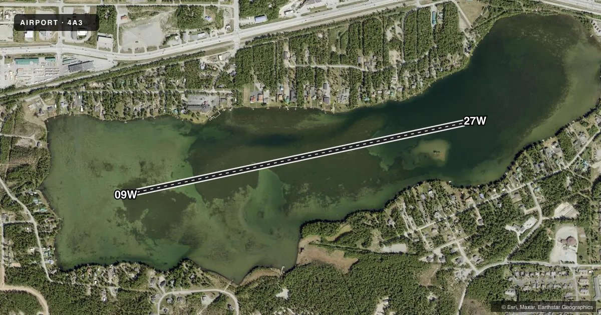
Full pagePattern entry · RWY 09W
LEFT TRAFFICAirport sketch
Runways drawn to scale from FAA survey coordinates, rendered over satellite imagery. Not for navigation.
Approaches & charts
Services on the field
Fuel grades, oxygen, maintenance, ramp storage and lighting — as declared to the FAA by the airport operator.
Fuel & services
- Fuel
- Not available
Ramp & ground
- Transient storage
- Not published
- Wind indicator
- No
- Segmented circle
- No
Fuel & FBOs
Cheapest 100LL and Jet A on the field and nearby. Always confirm with the FBO before taxi.
Airport notes
Surface conditions, obstructions, local procedures, lighting outages and other notes published with each FAA cycle.
General notes
- APCH OVR CITY.
- SMALL PUB DOCK NE SHORE.
- SHORT TERM MOORING - 907-373-1776.
- BE ALERT: BOATERS, WATER SKIERS, SNOW MACHINE ACT & FLOATING DEBRIS.
VFR map & nearby airports
VFR sectional. Tap any ICAO chip to open that airport.
Key facts · 4A3
Answer card- ICAO
- 4A3
- Name
- LAKE LUCILLE
- Location
- WASILLA, ALASKA
- Elevation
- 300 ft MSL
- Traffic pattern altitude
- 1,300 ft MSL (1,000 AGL)
- Control tower
- Non-towered (use CTAF)
- Total runways
- 1
- Longest runway
- 09W/27W · 5,000 ft
- Published ILS approaches
- 0
- Published frequencies
- 1
- Magnetic variation
- –
- Current flight rules
- VFR
- Current wind
- 000° at 0 kt
- Favored runway now
- –
Lake Lucille (4A3) sits in Wasilla, Alaska. Field elevation is 300 ft MSL. This is a seaplane base with one runway. The longest landing surface is 5,000 ft of water. No control tower is published, so use CTAF 122.8 for self-announce traffic. No ILS approaches are published here.
Pattern altitude is not published. For light piston operations, use the standard 1,000 ft AGL unless the current Chart Supplement or local procedures say otherwise. The published remarks matter here. Approach is over the city. Watch for boaters, water skiers, snow machine activity and floating debris. There is also a small public dock on the northeast shore. Short term mooring is available by phone at 907-373-1776.
No on-field FBOs are listed, so plan ahead before arrival. For a first-time pilot, the main thing to know is that this is a busy water environment, not a paved runway stop. Keep your scan wide on final and on the water. The field sits in a populated area. Expect more non-aviation traffic near the approach path than you would at a remote strip. Check the current FAA Chart Supplement and call the airport operator if you need current local procedures before you launch.