METAR & TAF PAUO
PAUO does not publish a METAR.
Showing the nearest reporting station: PAWS (WASILLA) · 18.2 NM away. Conditions at PAUO may differ.
METAR · PAWS
Observed 04:56Z
PAWS 280456Z AUTO 08003KT 10SM FEW026 OVC055 13/12 A2997 RMK AO2 SLP121 T01280117 $
- Wind
- 080° @ 3 kt
- Visibility
- 10 SM
- Temp / Dew
- 13°C / 12°C
- Altimeter
- 29.97 inHg
- Clouds
- OVC
- Density alt
- -35 ft
- Ceiling
- 5,500 ft AGL
- Rules
- VFR
Airport info & contacts
Manager on record, flight service, ARTCC, attendance schedule and pattern altitude — published by the FAA and refreshed every 28 days.
Location
- From city
- 1 NM NW
- VFR sectional
- ANCHORAGE
- ARTCC
- ZAN · ANCHORAGE
- NOTAM facility
- ENA (NOTAM-D)
Airport manager
- Name
- RAY ADAMS
- Phone
- 907-495-6286
- Address
- ST OF AK -- DOTPF WILLOW STATION, PO BOX 889, WILLOW AK 99688
Flight service · Hours
- FSS ENA
- KENAI907-283-72111-866-864-1737
- Attendance
- Unattended
Frequencies
Tap any row to copy the frequency to your clipboard.
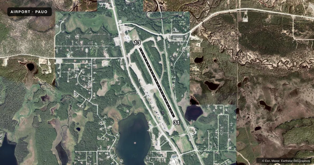
Runways & pattern
Full pagePattern entry · RWY 13
LEFT TRAFFICRunway end performance
| End | TORA | TODA | ASDA | LDA | VGSI | Approach lights | Obstruction |
|---|---|---|---|---|---|---|---|
| 13 | — | — | — | — | — | — | 15', road, 158' from thr, 0' R of cntrln, slope 10 |
| 31 | — | — | — | — | — | — | 43', trees, 300' from thr, 200' R of cntrln, slope 6 |
Declared distances in feet. TORA = takeoff run available, TODA = takeoff distance, ASDA = accelerate-stop, LDA = landing distance.
Airport sketch
Runways drawn to scale from FAA survey coordinates, rendered over satellite imagery. Not for navigation.
Approaches & charts
Services on the field
Fuel grades, oxygen, maintenance, ramp storage and lighting — as declared to the FAA by the airport operator.
Fuel & services
- Fuel
- 100LL
- Airframe repair
- Major
- Power plant repair
- Major
- Other services
- CHTR,INSTR
Ramp & ground
- Transient storage
- Tie-down
- Hangar
- Landing fee
- No fee published
- Customs
- Not available
- Lighting schedule
- SEE RMK
- Beacon schedule
- SEE RMK
- Beacon
- White / Green (civil land)(WG)
- Wind indicator
- Lighted
- Segmented circle
- Yes
Fuel & FBOs
Cheapest 100LL and Jet A on the field and nearby. Always confirm with the FBO before taxi.
Airport notes
Surface conditions, obstructions, local procedures, lighting outages and other notes published with each FAA cycle.
General notes
- RWY COND UNMNT; RCMD VISUAL INSP BFR USE.
- FLOAT PLANES ON WILLOW LAKE ACRS ROAD.
- WX RPRT HRLY WHEN AVBL.
- WX CAMERA AVBL ON INTERNET AT HTTPS://WEATHERCAMS.FAA.GOV
Lighting notes
- ACVT ROTG BCN - CTAF.
- ACTVT MIRL RWY 13/31 - CTAF.
Fuel notes
- 100LLCREDIT CARD SELF SVC H24.
Approach & departure obstructions
- 13THR MKD WITH FLEXIBLE REFLECTIVE MKRS & CONES.
- 31DTHR MKD WITH FLEXIBLE REFLECTIVE MKRS & CONES. TWY MARKINGS THRU DTHR.
- 31APCH SLP 20:1 TO DTHR.
VFR map & nearby airports
VFR sectional. Tap any ICAO chip to open that airport.
Key facts · PAUO
Answer card- ICAO
- PAUO
- Name
- WILLOW
- Location
- WILLOW, ALASKA
- Elevation
- 215.3 ft MSL
- Traffic pattern altitude
- 1,215.3 ft MSL (1,000 AGL)
- Control tower
- Non-towered (use CTAF)
- Total runways
- 1
- Longest runway
- 13/31 · 4,400 ft
- Published ILS approaches
- 0
- Published frequencies
- 1
- Magnetic variation
- 21°
- Current flight rules
- VFR
- Current wind
- 080° at 3 kt
- Favored runway now
- RWY 13
Willow Airport sits in Willow, Alaska. Field elevation is 215.3 ft MSL. The airport has one runway. Runway 13/31 is 4,400 ft long and gravel. There is no control tower. CTAF is 122.8. No ILS approaches are published here.
The published pattern altitude is not listed. For light piston traffic, use 1,000 ft AGL unless the current Chart Supplement says otherwise. Crowley Aviation Fuels is on the field. It carries AVGAS 100LL. Credit card self-serve fuel is available 24 hours a day. The rotating beacon is activated by CTAF. Medium intensity runway lights on 13/31 are also CTAF activated.
A first-time pilot should pay attention to the runway condition. It is unmonitored, so a visual check before use is a good idea. Runway 31 has a displaced threshold with a 20 to 1 approach slope to that threshold. The threshold markings use flexible reflective markers and cones. Taxiway markings continue through the displaced threshold. Runway 13 also uses flexible reflective markers and cones at the threshold. Float planes operate on Willow Lake across the road. Check the current Chart Supplement for any other local procedures before you go.