METAR & TAF PAMH
Current METAR
Observed 22:29Z
PAMH 272229Z AUTO 21006KT 6SM -RA BR BKN009 BKN019 OVC023 15/14 A2976 RMK AO2 CIG 007V013 P0000 $
- Wind
- 210° @ 6 kt
- Visibility
- 6 SM
- Temp / Dew
- 15°C / 14°C
- Altimeter
- 29.76 inHg
- Clouds
- OVC
- Density alt
- 1,044 ft
- Ceiling
- 900 ft AGL
- Rules
- IFR
Airport info & contacts
Manager on record, flight service, ARTCC, attendance schedule and pattern altitude — published by the FAA and refreshed every 28 days.
Location
- From city
- 0 NM SE
- VFR sectional
- MC GRATH
- ARTCC
- ZAN · ANCHORAGE
- NOTAM facility
- MHM (NOTAM-D)
Airport manager
- Name
- JASON LUDINGTON
- Phone
- (907) 451-5280
- Address
- 2301 PEGER RD, FAIRBANKS AK 99709
Flight service · Hours
- FSS FAI
- FAIRBANKS907-474-07881-866-248-6516
- Attendance
- Unattended
Frequencies
Tap any row to copy the frequency to your clipboard.
Runways & pattern
Full pagePattern entry · RWY 21
LEFT TRAFFICRunway end performance
| End | TORA | TODA | ASDA | LDA | VGSI | Approach lights | Obstruction |
|---|---|---|---|---|---|---|---|
| 03 | — | — | — | — | PAPI 4-box left(3°) | — | 6', trees, 0' from thr, 224' R of cntrln, slope 0 |
| 21 | — | — | — | — | — | — | 32', trees, 0' from thr, 213' R of cntrln, slope 0 |
Declared distances in feet. TORA = takeoff run available, TODA = takeoff distance, ASDA = accelerate-stop, LDA = landing distance.
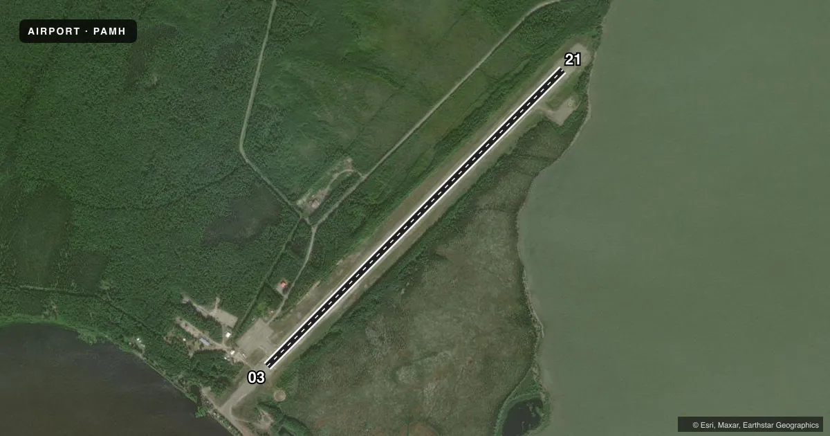
Airport sketch
Runways drawn to scale from FAA survey coordinates, rendered over satellite imagery. Not for navigation.
Approaches & charts
Services on the field
Fuel grades, oxygen, maintenance, ramp storage and lighting — as declared to the FAA by the airport operator.
Fuel & services
- Fuel
- Not available
- Oxygen (bottled)
- Not available
- Oxygen (bulk)
- Not available
- Airframe repair
- Not available
- Power plant repair
- Not available
Ramp & ground
- Transient storage
- Tie-down
- Landing fee
- No fee published
- Customs
- Not available
- Lighting schedule
- SEE RMK
- Beacon schedule
- SS-SR
- Beacon
- White / Green (civil land)(WG)
- Wind indicator
- Lighted
- Segmented circle
- Yes
Fuel & FBOs
Cheapest 100LL and Jet A on the field and nearby. Always confirm with the FBO before taxi.
Airport notes
Surface conditions, obstructions, local procedures, lighting outages and other notes published with each FAA cycle.
General notes
- BLM FIRE FIGHTING EQUIP & ACFT OPR DURG SUMMER MONTHS.
- RWY COND NOT MNT; RCMD VSB INSP PRIOR TO LNDG.
- SNOW REMOVAL OPS - CTAF.
- WX CAMERA AVBL ON INTERNET AT HTTPS://WEATHERCAMS.FAA.GOV
- ALERT: CLSD CROSS RWY WITH FADED MARKINGS W OF RWY 03 THR.
- COLD TEMPERATURE AIRPORT. ALTITUDE CORRECTION REQUIRED AT OR BELOW -36C.
Lighting notes
- ACTVT PAPI RWY 03; MIRL RWY 03/21 - CTAF.
Other notes
- TSNT TIE DOWN POINT AVBL.
- INACCURATE; SURROUNDED BY TREES.
VFR map & nearby airports
VFR sectional. Tap any ICAO chip to open that airport.
Key facts · PAMH
Answer card- ICAO
- PAMH
- Name
- MINCHUMINA
- Location
- MINCHUMINA, ALASKA
- Elevation
- 681.8 ft MSL
- Traffic pattern altitude
- 1,681.8 ft MSL (1,000 AGL)
- Control tower
- Non-towered (use CTAF)
- Total runways
- 1
- Longest runway
- 03/21 · 4,184 ft
- Published ILS approaches
- 0
- Published frequencies
- 1
- Magnetic variation
- 14°
- Current flight rules
- IFR
- Current wind
- 210° at 6 kt
- Favored runway now
- RWY 21
Minchumina Airport sits in Minchumina, Alaska. Field elevation is 681.8 ft MSL. The airport has one runway. Runway 03/21 is 4,184 ft long and gravel. There is no control tower. CTAF is 122.9.
No ILS approaches are published here. Pattern altitude is not published. For light piston planning, use the standard 1,000 ft AGL pattern unless the current Chart Supplement says otherwise. The airport remarks matter here. Runway condition is not maintained, so a visual inspection before landing is a good idea. The wind indicator is reported as inaccurate because trees surround it. There is also a closed cross runway west of the Runway 03 threshold with faded markings, so keep your scan tight on final and during rollout.
Published lighting includes a precision approach path indicator for Runway 03 and medium intensity runway lights for Runways 03 and 21, activated on CTAF. Snow removal operations can be on the CTAF. This is a cold temperature airport. Altitude correction is required at or below minus 36 degrees Celsius. No on-field FBOs are listed. Check the current FAA Chart Supplement and contact the airport operator directly before arrival for any current field conditions or services.