METAR & TAF 80A
80A does not publish a METAR.
Showing the nearest reporting station: PATA (RALPH M CALHOUN MEML) · 23.9 NM away. Conditions at 80A may differ.
METAR · PATA
Observed 02:36Z
PATA 270236Z 15004KT 10SM BKN080 BKN110 BKN200 25/11 A2970 RMK AO2 TSE30 TS SW T02500111
- Wind
- 150° @ 4 kt
- Visibility
- 10 SM
- Temp / Dew
- 25°C / 11°C
- Altimeter
- 29.70 inHg
- Clouds
- BKN
- Density alt
- 2,109 ft
- Ceiling
- 8,000 ft AGL
- Rules
- VFR
Airport info & contacts
Manager on record, flight service, ARTCC, attendance schedule and pattern altitude — published by the FAA and refreshed every 28 days.
Location
- From city
- 0 NM N
- VFR sectional
- FAIRBANKS
- ARTCC
- ZAN · ANCHORAGE
- NOTAM facility
- FAI (NOTAM-D)
Airport manager
- Name
- STATE OF ALASKA, DNR, DMLW
- Phone
- 907-451-2740
- Address
- 3700 AIRPORT WAY, FAIRBANKS AK 99709
Flight service · Hours
- FSS FAI
- FAIRBANKS907-474-07881-866-248-6516
- Attendance
- Unattended
Frequencies
Tap any row to copy the frequency to your clipboard.
Runways & pattern
Full pagePattern entry · RWY 20
LEFT TRAFFICRunway end performance
| End | TORA | TODA | ASDA | LDA | VGSI | Approach lights | Obstruction |
|---|---|---|---|---|---|---|---|
| 02 | — | — | — | — | — | — | 40', tree, 0' from thr, 50' R of cntrln, slope 0 |
| 20 | — | — | — | — | — | — | 40', tree, 0' from thr, 50' R of cntrln, slope 0 |
Declared distances in feet. TORA = takeoff run available, TODA = takeoff distance, ASDA = accelerate-stop, LDA = landing distance.
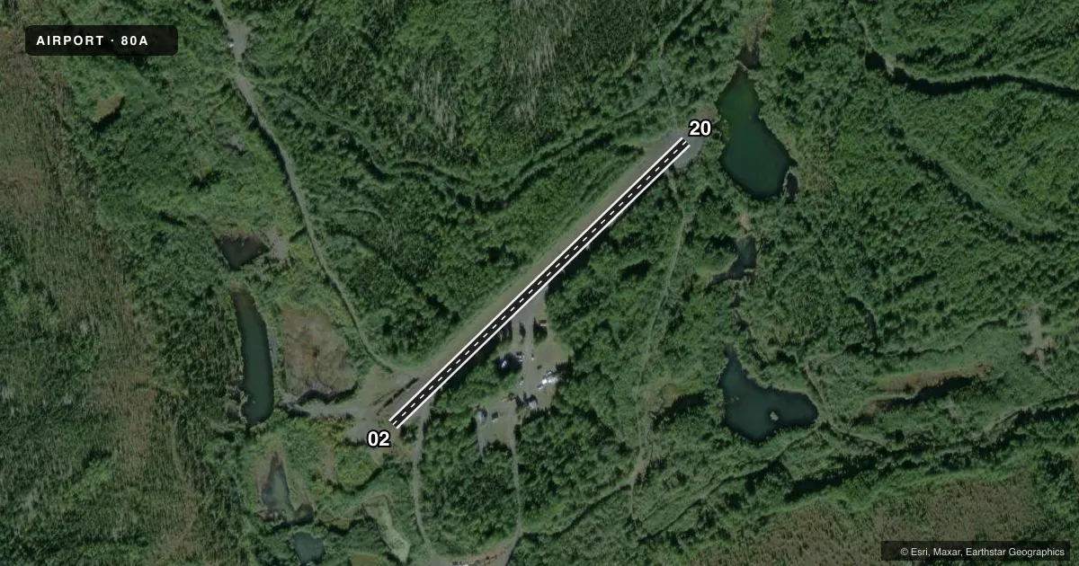
Airport sketch
Runways drawn to scale from FAA survey coordinates, rendered over satellite imagery. Not for navigation.
Approaches & charts
Services on the field
Fuel grades, oxygen, maintenance, ramp storage and lighting — as declared to the FAA by the airport operator.
Fuel & services
- Fuel
- Not available
- Oxygen (bottled)
- Not available
- Oxygen (bulk)
- Not available
- Airframe repair
- Not available
- Power plant repair
- Not available
Ramp & ground
- Transient storage
- Not published
- Landing fee
- No fee published
- Customs
- Not available
- Wind indicator
- No
- Segmented circle
- No
Fuel & FBOs
Cheapest 100LL and Jet A on the field and nearby. Always confirm with the FBO before taxi.
Airport notes
Surface conditions, obstructions, local procedures, lighting outages and other notes published with each FAA cycle.
General notes
- BE ALERT WINDS ERRATIC.
- HEAVY EQUIPMENT AND DRAG LINE BOOM INVOF RY; RECOMMEND FLYBY BEFORE LANDING.
- BE ALERT: RY USED AS ROAD BY MINING EQUIPMENT.
Approach & departure obstructions
- 20BIRCH FOREST ON THLD.
Other notes
- 02/20NO LINE OF SIGHT BTN RY ENDS. ROCKS UP TO 6 INCH DIA.
VFR map & nearby airports
VFR sectional. Tap any ICAO chip to open that airport.
Key facts · 80A
Answer card- ICAO
- 80A
- Name
- AMERICAN CREEK
- Location
- AMERICAN CREEK, ALASKA
- Elevation
- 513 ft MSL
- Traffic pattern altitude
- 1,513 ft MSL (1,000 AGL)
- Control tower
- Non-towered (use CTAF)
- Total runways
- 1
- Longest runway
- 02/20 · 1,500 ft
- Published ILS approaches
- 0
- Published frequencies
- 1
- Magnetic variation
- 26°
- Current flight rules
- VFR
- Current wind
- 150° at 4 kt
- Favored runway now
- RWY 20
American Creek Airport (80A) sits in American Creek, Alaska. The field elevation is 513 ft MSL. It has one runway. Runway 02/20 is 1,500 ft long with a turf-gravel surface. There is no control tower. CTAF is 122.9.
No ILS approaches are published here. The pattern altitude is not published, so use standard 1,000 ft AGL for light piston operations unless the current FAA Chart Supplement says otherwise. The runway headings are magnetic. Runway 02 is 45.9587964471407° magnetic. Runway 20 is 225.958796447141° magnetic.
There are no on-field FBOs listed, so plan on self-sufficiency and verify services with the airport operator before you go. The published remarks matter here. Heavy equipment and a drag line boom are near the runway. A flyby before landing is recommended. There is also a birch forest on the threshold of runway 20. The runway has no line of sight between the ends. Rocks up to 6 inch diameter are present. The runway is also used as a road by mining equipment. Winds are reported as erratic, so expect changing conditions on final and during rollout. This is a small, non-towered field with local hazards that deserve a careful pre-landing look.