METAR & TAF PAML
PAML does not publish a METAR.
Showing the nearest reporting station: PATA (RALPH M CALHOUN MEML) · 38.6 NM away. Conditions at PAML may differ.
METAR · PATA
Observed 17:52Z
PATA 271752Z 13004KT 10SM SCT080CB 21/14 A2972 RMK AO2 SLP065 CB ALQDS T02060139 10211 20117 53001
- Wind
- 130° @ 4 kt
- Visibility
- 10 SM
- Temp / Dew
- 21°C / 14°C
- Altimeter
- 29.72 inHg
- Clouds
- SCT
- Density alt
- 1,309 ft
- Ceiling
- Unlimited
- Rules
- VFR
Airport info & contacts
Manager on record, flight service, ARTCC, attendance schedule and pattern altitude — published by the FAA and refreshed every 28 days.
Location
- From city
- 0 NM SW
- VFR sectional
- FAIRBANKS
- ARTCC
- ZAN · ANCHORAGE
- NOTAM facility
- FAI (NOTAM-D)
Airport manager
- Name
- JEFF RUSSELL
- Phone
- 907-451-2207
- Address
- 2301 PEGER RD, FAIRBANKS AK 99709
Flight service · Hours
- FSS FAI
- FAIRBANKS907-474-07881-866-248-6516
- Attendance
- Unattended
Frequencies
Tap any row to copy the frequency to your clipboard.
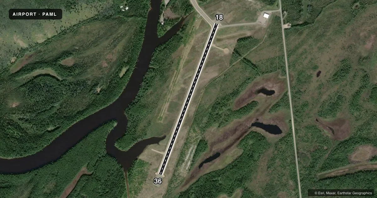
Runways & pattern
Full pagePattern entry · RWY 18
LEFT TRAFFICRunway end performance
| End | TORA | TODA | ASDA | LDA | VGSI | Approach lights | Obstruction |
|---|---|---|---|---|---|---|---|
| 18 | — | — | — | — | — | — | 15', road, 0' from thr, 130' R of cntrln, slope 0 |
| 36 | — | — | — | — | — | — | 4', brush, 4' from thr, 118' R of cntrln, slope 1 |
Declared distances in feet. TORA = takeoff run available, TODA = takeoff distance, ASDA = accelerate-stop, LDA = landing distance.
Airport sketch
Runways drawn to scale from FAA survey coordinates, rendered over satellite imagery. Not for navigation.
Approaches & charts
Services on the field
Fuel grades, oxygen, maintenance, ramp storage and lighting — as declared to the FAA by the airport operator.
Fuel & services
- Fuel
- Not available
- Oxygen (bottled)
- Not available
- Oxygen (bulk)
- Not available
- Airframe repair
- Minor
- Power plant repair
- Minor
Ramp & ground
- Transient storage
- Tie-down
- Landing fee
- No fee published
- Customs
- Not available
- Lighting schedule
- SEE RMK
- Beacon schedule
- SS-SR
- Beacon
- White / Green (civil land)(WG)
- Wind indicator
- Lighted
- Segmented circle
- Yes
Fuel & FBOs
Cheapest 100LL and Jet A on the field and nearby. Always confirm with the FBO before taxi.
Airport notes
Surface conditions, obstructions, local procedures, lighting outages and other notes published with each FAA cycle.
General notes
- MAINTAINED WINTER FOR WHEEL ACFT.
- RY CONDITION NOT MONITORED; RECOMMEND VISUAL INSPECTION PRIOR TO LANDING.
- SKI STRIP PARALLEL AND WEST OF RY 18/36 CLSD/ NOT USABLE.
- COLD TEMPERATURE AIRPORT. ALTITUDE CORRECTION REQUIRED AT OR BELOW -21C.
Lighting notes
- ACTVT MIRL RY 18/36 AND WINDSOCK - CTAF.
Other notes
- 18/36RY TREATED WITH DUST PALLIATIVE.
VFR map & nearby airports
VFR sectional. Tap any ICAO chip to open that airport.
Key facts · PAML
Answer card- ICAO
- PAML
- Name
- MANLEY HOT SPRINGS
- Location
- MANLEY HOT SPRINGS, ALASKA
- Elevation
- 275.3 ft MSL
- Traffic pattern altitude
- 1,275.3 ft MSL (1,000 AGL)
- Control tower
- Non-towered (use CTAF)
- Total runways
- 1
- Longest runway
- 18/36 · 3,400 ft
- Published ILS approaches
- 0
- Published frequencies
- 2
- Magnetic variation
- 18°
- Current flight rules
- VFR
- Current wind
- 130° at 4 kt
- Favored runway now
- RWY 18
Manley Hot Springs Airport sits in Manley Hot Springs, Alaska. Field elevation is 275.3 ft MSL. The airport has one runway. Runway 18/36 is 3,400 ft long and gravel. There is no control tower. CTAF and UNICOM are both 122.8. No ILS approaches are published here.
Pattern altitude is not published. Use 1,000 ft AGL for light piston operations unless the current Chart Supplement says otherwise. That puts the pattern at about 1,275 ft MSL based on the field elevation, but verify before you fly. The airport is maintained in winter for wheel aircraft. Runway 18/36 is treated with dust palliative. Runway condition is not monitored, so a visual inspection before landing is a good idea. The ski strip parallel and west of runway 18/36 is closed and not usable.
This is a cold temperature airport. Altitude correction is required at or below minus 21 degrees Celsius. Medium intensity runway lights are available on runway 18/36. The windsock is on the CTAF frequency. There are no on-field FBOs listed, so plan on coordinating directly with the airport operator or checking current field status before arrival.