METAR & TAF PACL
PACL does not publish a METAR.
Showing the nearest reporting station: PANN (NENANA MUNI) · 14.9 NM away. Conditions at PACL may differ.
METAR · PANN
Observed 11:53Z
PANN 271153Z AUTO 00000KT 10SM BKN090 OVC110 16/14 A2971 RMK AO2 SLP064 60000 T01560139 10194 20150 51002 TSNO $
- Wind
- 000° @ 0 kt
- Visibility
- 10 SM
- Temp / Dew
- 16°C / 14°C
- Altimeter
- 29.71 inHg
- Clouds
- OVC
- Density alt
- 1,074 ft
- Ceiling
- 9,000 ft AGL
- Rules
- VFR
Airport info & contacts
Manager on record, flight service, ARTCC, attendance schedule and pattern altitude — published by the FAA and refreshed every 28 days.
Location
- From city
- 3 NM SE
- VFR sectional
- FAIRBANKS
- ARTCC
- ZAN · ANCHORAGE
- NOTAM facility
- FAI (NOTAM-D)
Airport manager
- Name
- JASON LUDINGTON
- Phone
- 907-451-5280
- Address
- 2301 PEGER RD, FAIRBANKS AK 99709-5316
Flight service · Hours
- FSS FAI
- FAIRBANKS907-474-07881-866-248-6516
- Attendance
- Unattended
Frequencies
Tap any row to copy the frequency to your clipboard.
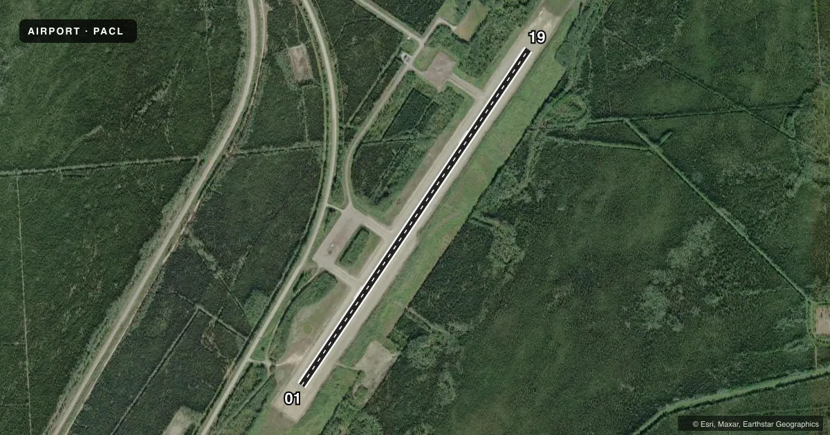
Runways & pattern
Full pagePattern entry · RWY 01
RIGHT TRAFFICRunway end performance
| End | TORA | TODA | ASDA | LDA | VGSI | Approach lights | Obstruction |
|---|---|---|---|---|---|---|---|
| 01 | — | — | — | — | — | — | 45', trees, 420' from thr, 180' R of cntrln, slope 4 |
| 19 | — | — | — | — | — | — | 42', trees, 350' from thr, 160' R of cntrln, slope 3 |
Declared distances in feet. TORA = takeoff run available, TODA = takeoff distance, ASDA = accelerate-stop, LDA = landing distance.
Airport sketch
Runways drawn to scale from FAA survey coordinates, rendered over satellite imagery. Not for navigation.
Approaches & charts
Services on the field
Fuel grades, oxygen, maintenance, ramp storage and lighting — as declared to the FAA by the airport operator.
Fuel & services
- Fuel
- Not available
Ramp & ground
- Transient storage
- Tie-down
- Landing fee
- No fee published
- Customs
- Not available
- Lighting schedule
- SEE RMK
- Beacon schedule
- SS-SR
- Beacon
- White / Green (civil land)(WG)
- Wind indicator
- Lighted
- Segmented circle
- Yes
Fuel & FBOs
Cheapest 100LL and Jet A on the field and nearby. Always confirm with the FBO before taxi.
Airport notes
Surface conditions, obstructions, local procedures, lighting outages and other notes published with each FAA cycle.
General notes
- 253 FT ANT 4000 FT E.
- RWY COND NOT MNT; RCMD VISUAL INSP PRIOR TO LNDG.
- ALERT: AVOID RSTRD AREA 1 NM W & PVT ARPT 3 NM SW.
- GLIDER ACT APR-SEP ON & INVOF ARPT.
- TWY C CLSD DURG WINTER.
- CTN: HIGH LEVEL RADIO ENERGY; PSBL AIRBORNE ELEC SYS DMG. RMN CLEAR OF R-2206 WHEN ACTV; MNT 133.25 FOR STATUS. SEE SPL NOTICE FOR CLEAR RADIATION HAZ.
Lighting notes
- ACTVT MIRL RWY 01/19 - CTAF.
Approach & departure obstructions
- 01THLD MKRS.
- 19THLD MKRS.
Other notes
- 01/19SAFETY AREA; 300 FT OVRN EACH END.
VFR map & nearby airports
VFR sectional. Tap any ICAO chip to open that airport.
Key facts · PACL
Answer card- ICAO
- PACL
- Name
- CLEAR
- Location
- CLEAR, ALASKA
- Elevation
- 559.4 ft MSL
- Traffic pattern altitude
- 1,559.4 ft MSL (1,000 AGL)
- Control tower
- Non-towered (use CTAF)
- Total runways
- 1
- Longest runway
- 01/19 · 3,997 ft
- Published ILS approaches
- 0
- Published frequencies
- 1
- Magnetic variation
- 27°
- Current flight rules
- VFR
- Current wind
- 000° at 0 kt
- Favored runway now
- –
CLEAR Airport (PACL) sits in CLEAR, Alaska at 559.4 ft MSL. It has one runway, 01/19, which is 3,997 ft long and paved. There is no control tower. CTAF is 122.9. No ILS approaches are published here, so plan with that in mind if the weather is moving around.
The published pattern altitude is not listed. For local pattern work, use the current FAA Chart Supplement or call the airport operator before you go. The runway lights on 01/19 are medium intensity and are activated by CTAF. Threshold markers are installed at both ends. There is also a 300-foot overrun safety area at each end.
No on-field FBOs are listed. Verify fuel and services with the airport operator or by calling the field before arrival. Published remarks also call out runway condition as not maintained, so a visual inspection before landing is recommended. Glider activity occurs from April through September on and near the airport. Taxiway C is closed in winter. There is also a restricted area 1 NM west, plus a private airport 3 NM southwest. A 253-foot antenna sits 4,000 ft east of the airport. The field is also near R-2206, so check status before you go and stay clear when it is active.