METAR & TAF PAAN
PAAN does not publish a METAR.
Showing the nearest reporting station: PANN (NENANA MUNI) · 36.4 NM away. Conditions at PAAN may differ.
METAR · PANN
Observed 18:53Z
PANN 271853Z AUTO 23003KT 10SM FEW049 OVC065 18/15 A2972 RMK AO2 SLP069 T01780150 TSNO $
- Wind
- 230° @ 3 kt
- Visibility
- 10 SM
- Temp / Dew
- 18°C / 15°C
- Altimeter
- 29.72 inHg
- Clouds
- OVC
- Density alt
- 2,741 ft
- Ceiling
- 6,500 ft AGL
- Rules
- VFR
Airport info & contacts
Manager on record, flight service, ARTCC, attendance schedule and pattern altitude — published by the FAA and refreshed every 28 days.
Location
- From city
- 39 NM SE
- VFR sectional
- FAIRBANKS
- ARTCC
- ZAN · ANCHORAGE
- NOTAM facility
- FAI (NOTAM-D)
Airport manager
- Name
- JASON LUDINGTON
- Phone
- (907) 451-5280
- Address
- 2301 PEGER ROAD, FAIRBANKS AK 99709
Flight service · Hours
- FSS FAI
- FAIRBANKS907-474-07881-866-248-6516
- Attendance
- Unattended
Frequencies
Tap any row to copy the frequency to your clipboard.
Runways & pattern
Full pagePattern entry · RWY 27
LEFT TRAFFICRunway end performance
| End | TORA | TODA | ASDA | LDA | VGSI | Approach lights | Obstruction |
|---|---|---|---|---|---|---|---|
| 09 | — | — | — | — | — | — | 38', trees, 0' from thr, 110' R of cntrln, slope 0 |
| 27 | — | — | — | — | — | — | 15', brush, 0' from thr, 69' R of cntrln, slope 0 |
Declared distances in feet. TORA = takeoff run available, TODA = takeoff distance, ASDA = accelerate-stop, LDA = landing distance.
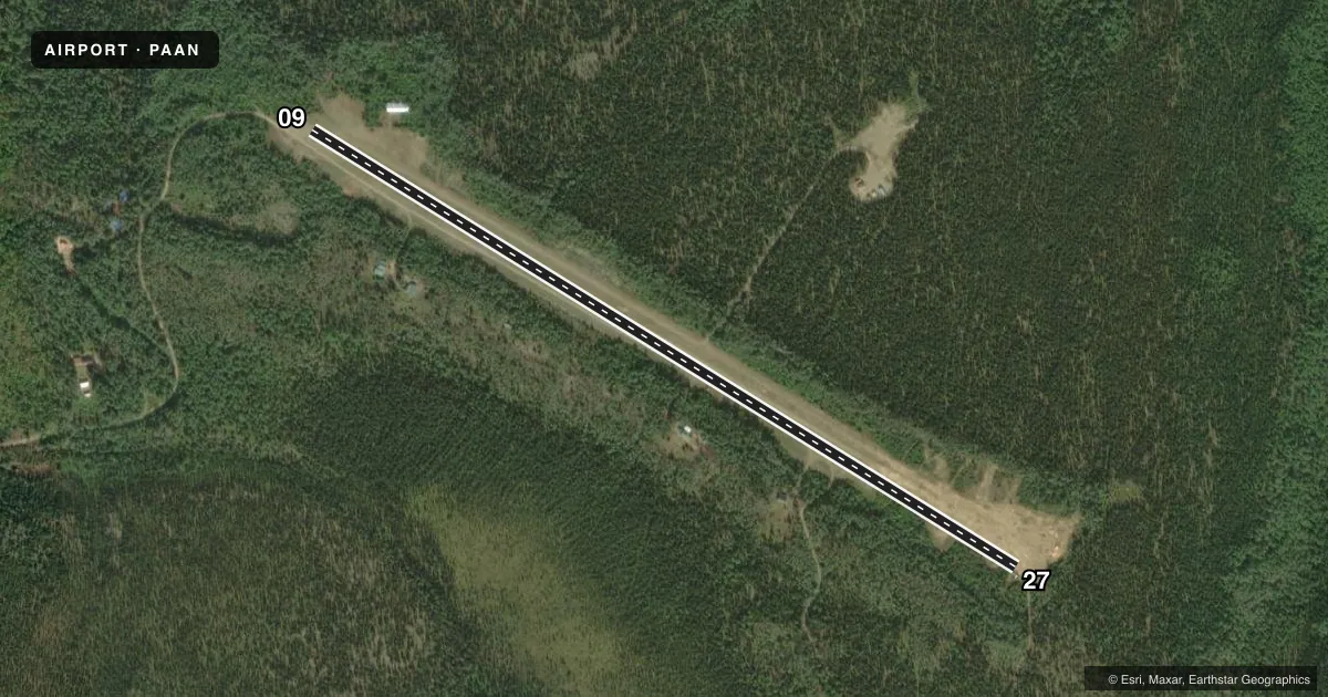
Airport sketch
Runways drawn to scale from FAA survey coordinates, rendered over satellite imagery. Not for navigation.
Approaches & charts
Services on the field
Fuel grades, oxygen, maintenance, ramp storage and lighting — as declared to the FAA by the airport operator.
Fuel & services
- Fuel
- Not available
Ramp & ground
- Transient storage
- Not published
- Wind indicator
- Yes
- Segmented circle
- No
Fuel & FBOs
Cheapest 100LL and Jet A on the field and nearby. Always confirm with the FBO before taxi.
Airport notes
Surface conditions, obstructions, local procedures, lighting outages and other notes published with each FAA cycle.
General notes
- RY CONDITION NOT MONITORED; RECOMMEND VISUAL INSP PRIOR TO LANDING.
- NO SVCS AVBL.
- 20 FT TREES ON BOTH SIDES OF RWY WITHIN 60-70 FT OF CENTERLINE.
Other notes
- GOLD KING CREEK
- 09/27ROCKS UP TO 6 INCHES ON RY SFC.
VFR map & nearby airports
VFR sectional. Tap any ICAO chip to open that airport.
Key facts · PAAN
Answer card- ICAO
- PAAN
- Name
- GOLD KING CREEK
- Location
- FAIRBANKS, ALASKA
- Elevation
- 1,720 ft MSL
- Traffic pattern altitude
- 2,720 ft MSL (1,000 AGL)
- Control tower
- Non-towered (use CTAF)
- Total runways
- 1
- Longest runway
- 09/27 · 2,558 ft
- Published ILS approaches
- 0
- Published frequencies
- 1
- Magnetic variation
- 25°
- Current flight rules
- VFR
- Current wind
- 230° at 3 kt
- Favored runway now
- RWY 27
Gold King Creek is in Fairbanks, Alaska. The field elevation is 1,720 ft MSL. It has one runway. Runway 09/27 is 2,558 ft long with a gravel-dirt surface. The airport is not towered. CTAF is 122.9. No ILS approaches are published.
Pattern altitude is not published. Use standard 1,000 ft AGL for light piston operations unless the current FAA Chart Supplement says otherwise. That puts the pattern at 2,720 ft MSL by the standard rule of thumb. Verify the published traffic pattern before you go. The runway headings are magnetic. Runway 09/27 is listed with headings 122° and 302°.
This is a rough field. Published remarks say runway condition is not monitored. A visual inspection is recommended before landing. Rocks up to 6 inches are on the runway surface. There are 20-foot trees on both sides of the runway within 60 to 70 feet of the centerline. No services are available on the field. Plan for a self-sufficient arrival and departure. Check density altitude, performance and your go-around options before committing.