METAR & TAF PANN
Current METAR
Observed 21:53Z
PANN 272153Z AUTO VRB03KT 10SM OVC090 19/14 A2972 RMK AO2 SLP069 T01940144 TSNO $
- Wind
- VAR @ 3 kt
- Visibility
- 10 SM
- Temp / Dew
- 19°C / 14°C
- Altimeter
- 29.72 inHg
- Clouds
- OVC
- Density alt
- 1,184 ft
- Ceiling
- 9,000 ft AGL
- Rules
- VFR
Airport info & contacts
Manager on record, flight service, ARTCC, attendance schedule and pattern altitude — published by the FAA and refreshed every 28 days.
Location
- From city
- 1 NM S
- VFR sectional
- FAIRBANKS
- ARTCC
- ZAN · ANCHORAGE
- NOTAM facility
- ENN (NOTAM-D)
Airport manager
- Name
- DAN SMITH
- Phone
- 907-888-9065
- Address
- NENANA AK 99760
Flight service · Hours
- FSS FAI
- FAIRBANKS907-474-07881-866-248-6516
- Attendance
- UNATTND
Frequencies
Tap any row to copy the frequency to your clipboard.
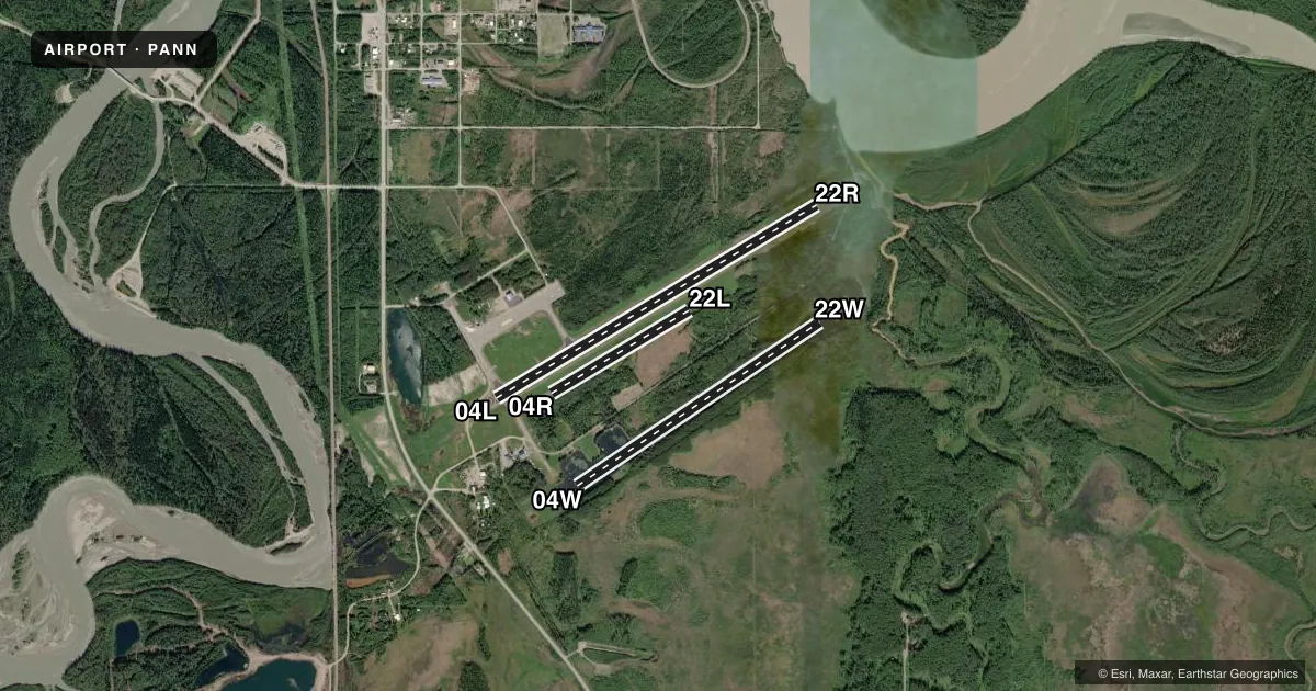
Runways & pattern
Full pagePattern entry · RWY 04W
RIGHT TRAFFIC| Runway | Heading (°M) | Length | Surface | Traffic |
|---|---|---|---|---|
| 04L/22R | 46° / 226° | 4,600 ft | ASPH | 04L R |
| 04W/22WFavored | 43° / 223° | 3,601 ft | WATER | 04W R |
| 04R/22L | 46° / 226° | 1,980 ft | TURF | 04R R |
Runway end performance
| End | TORA | TODA | ASDA | LDA | VGSI | Approach lights | Obstruction |
|---|---|---|---|---|---|---|---|
| 04L | — | — | — | — | PAPI 4-box left(3°) | — | 30', trees, 201' from thr, 220' R of cntrln, slope 0 |
| 22R | — | — | — | — | PAPI 4-box left(3°) | — | 31', trees, 360' from thr, 142' R of cntrln, slope 5 |
| 04R | — | — | — | — | — | — | 30', trees, 0' from thr, 65' R of cntrln, slope 0 |
| 22L | — | — | — | — | — | — | 23', trees, 0' from thr, 70' R of cntrln, slope 0 |
Declared distances in feet. TORA = takeoff run available, TODA = takeoff distance, ASDA = accelerate-stop, LDA = landing distance.
Airport sketch
Runways drawn to scale from FAA survey coordinates, rendered over satellite imagery. Not for navigation.
Approaches & charts
Services on the field
Fuel grades, oxygen, maintenance, ramp storage and lighting — as declared to the FAA by the airport operator.
Fuel & services
- Fuel
- 100LLA
Ramp & ground
- Transient storage
- Tie-down
- Landing fee
- No fee published
- Customs
- Not available
- Lighting schedule
- SEE RMK
- Beacon schedule
- SS-SR
- Beacon
- White / Green (civil land)(WG)
- Wind indicator
- Lighted
- Segmented circle
- Yes
Fuel & FBOs
Cheapest 100LL and Jet A on the field and nearby. Always confirm with the FBO before taxi.
Airport notes
Surface conditions, obstructions, local procedures, lighting outages and other notes published with each FAA cycle.
General notes
- SHALLOW WATER NEAR FLOAT POND RAMP AREA.
- WX CAMERA AVBL ON INTERNET AT HTTPS://WEATHERCAMS.FAA.GOV
- RWY COND UNMNT; RCMD VISUAL INSP BFR USE.
- SELF SVC FUEL H24 WITH CREDIT CARD.
Lighting notes
- ACTVT REIL RWY 04L & 22R; PAPI 04L & 22R; MIRL RWY 04L/22R - CTAF.
Runway surface & condition
- 04R/22LFULL LEN MAY BE UNAVBL DURG SUMMER. SKI USE WHEN FROZEN.
- 04L/22ROTS INDEF.
- 04R/22LOTS INDEF.
Other notes
- DAMAGED.
VFR map & nearby airports
VFR sectional. Tap any ICAO chip to open that airport.
Key facts · PANN
Answer card- ICAO
- PANN
- Name
- NENANA MUNI
- Location
- NENANA, ALASKA
- Elevation
- 367.7 ft MSL
- Traffic pattern altitude
- 1,367.7 ft MSL (1,000 AGL)
- Control tower
- Non-towered (use CTAF)
- Total runways
- 3
- Longest runway
- 04L/22R · 4,600 ft
- Published ILS approaches
- 0
- Published frequencies
- 5
- Magnetic variation
- 13°
- Current flight rules
- VFR
- Current wind
- 000° at 3 kt
- Favored runway now
- RWY 04W
Nenana Muni sits in Nenana, Alaska. Field elevation is 367.7 ft MSL. The airport has three runways. The longest is 4,600 ft on 04L/22R. It is a non-towered field. CTAF is 122.1. Approach and departure service is handled by Fairbanks on the published frequencies. No ILS approaches are published here.
Pattern altitude is not published. Use 1,000 ft AGL for light piston traffic unless local procedures or current guidance say otherwise. The published remarks matter here. Self-service fuel is available 24 hours with credit card. Shallow water is near the float pond ramp area. The runway condition is unmonitored, so a visual inspection before use is a good idea. The segmented circle is damaged. Runway 04L/22R has REILs and PAPI listed. The runway lighting is out of service indefinitely. Runway 04R/22L lighting is also out of service indefinitely.
The airport has asphalt, water and turf surfaces. Runway 04R/22L is 1,980 ft. Full length may be unavailable in summer. Ski use is permitted when frozen. This is an Alaska field with mixed surface options, so plan for seasonal surface changes and verify the current condition before you go.