METAR & TAF 2Z3
2Z3 does not publish a METAR.
Showing the nearest reporting station: PAIN (MC KINLEY NTL PARK) · 18.6 NM away. Conditions at 2Z3 may differ.
METAR · PAIN
Observed 20:56Z
PAIN 272056Z AUTO VRB05KT 10SM -RA FEW038 BKN055 15/10 A2981 RMK AO2 RAB35 SLP100 P0000 60001 T01500100 53005 TSNO $
- Wind
- VAR @ 5 kt
- Visibility
- 10 SM
- Temp / Dew
- 15°C / 10°C
- Altimeter
- 29.81 inHg
- Clouds
- BKN
- Density alt
- 3,629 ft
- Ceiling
- 5,500 ft AGL
- Rules
- VFR
Airport info & contacts
Manager on record, flight service, ARTCC, attendance schedule and pattern altitude — published by the FAA and refreshed every 28 days.
Location
- From city
- 7 NM E
- VFR sectional
- FAIRBANKS
- ARTCC
- ZAN · ANCHORAGE
- NOTAM facility
- FAI (NOTAM-D)
Airport manager
- Name
- STATE OF ALASKA, DNR, DMLW
- Phone
- 907-451-2740
- Address
- 3700 AIRPORT WAY, FAIRBANKS AK 99709
Flight service · Hours
- FSS FAI
- FAIRBANKS907-474-07881-866-248-6516
- Attendance
- Unattended
Frequencies
Tap any row to copy the frequency to your clipboard.
Runways & pattern
Full pagePattern entry · RWY 26
RIGHT TRAFFICRunway end performance
| End | TORA | TODA | ASDA | LDA | VGSI | Approach lights | Obstruction |
|---|---|---|---|---|---|---|---|
| 08 | — | — | — | — | — | — | 10', brush, 0' from thr, slope 0 |
| 26 | — | — | — | — | — | — | 10', brush, 0' from thr, 0' R of cntrln, slope 0 |
Declared distances in feet. TORA = takeoff run available, TODA = takeoff distance, ASDA = accelerate-stop, LDA = landing distance.
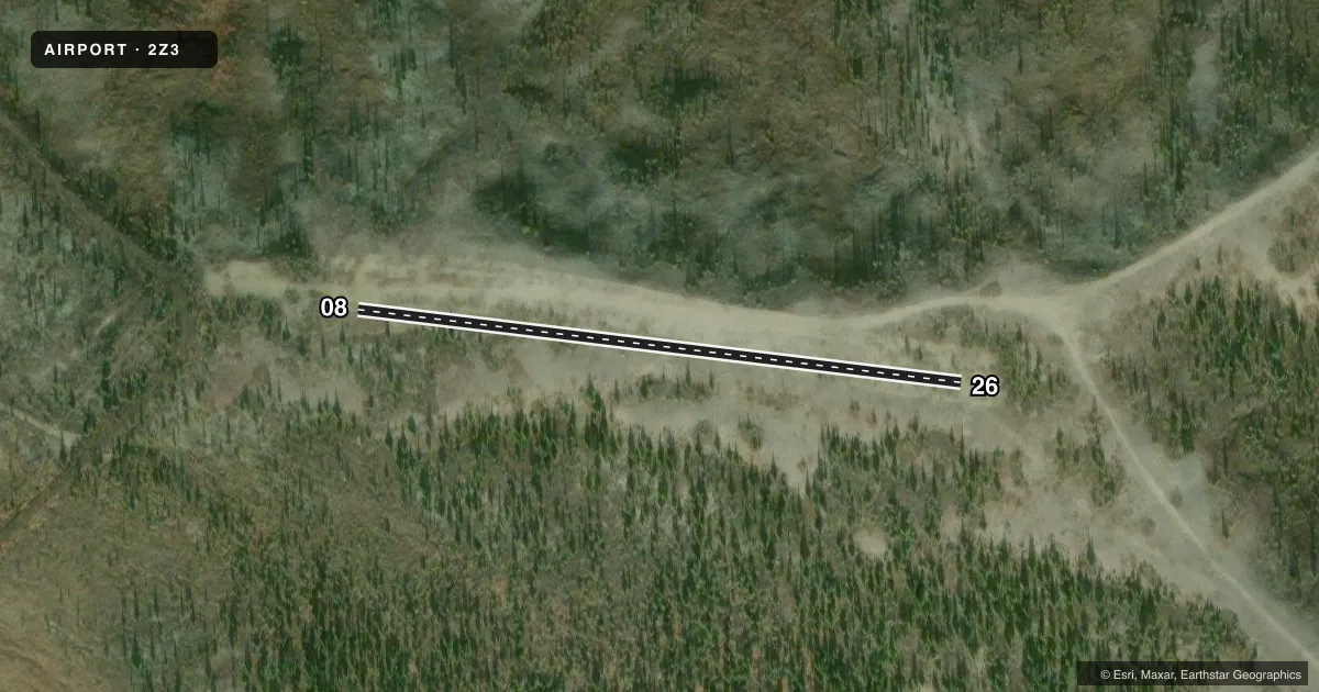
Airport sketch
Runways drawn to scale from FAA survey coordinates, rendered over satellite imagery. Not for navigation.
Approaches & charts
Services on the field
Fuel grades, oxygen, maintenance, ramp storage and lighting — as declared to the FAA by the airport operator.
Fuel & services
- Fuel
- Not available
- Oxygen (bottled)
- Not available
- Oxygen (bulk)
- Not available
- Airframe repair
- Not available
- Power plant repair
- Not available
Ramp & ground
- Transient storage
- Not published
- Landing fee
- No fee published
- Customs
- Not available
- Wind indicator
- No
- Segmented circle
- No
Fuel & FBOs
Cheapest 100LL and Jet A on the field and nearby. Always confirm with the FBO before taxi.
Airport notes
Surface conditions, obstructions, local procedures, lighting outages and other notes published with each FAA cycle.
General notes
- EMERG FLD FOR LGT PLANES ONLY; KNKOWLEDGE OF STRIP RCMD PRIOR TO USE; SEVERE TURBC AT ALL TIMES.
- TERRAIN DROPS OFF SHARPLY ON EAST SIDE OF RUNWAY.
- 15 DEGREE DOGLEG TO THE SOUTH ON WEST END.
Other notes
- LCTD 8 SM E OF FERRY.
- 08/26LOOSE ROCKS ON RWY SFC. UP TO 4 INCH TURF & BRUSH GROWING ON RWY SFC UP TO 30 INCHES TALL. BRUSH AND TREES UP TO 20 FT TALL GROWING ON RWY SFC.
VFR map & nearby airports
VFR sectional. Tap any ICAO chip to open that airport.
Key facts · 2Z3
Answer card- ICAO
- 2Z3
- Name
- EVA CREEK
- Location
- EVA CREEK, ALASKA
- Elevation
- 2,817 ft MSL
- Traffic pattern altitude
- 3,817 ft MSL (1,000 AGL)
- Control tower
- Non-towered (use CTAF)
- Total runways
- 1
- Longest runway
- 08/26 · 950 ft
- Published ILS approaches
- 0
- Published frequencies
- 1
- Magnetic variation
- 27°
- Current flight rules
- VFR
- Current wind
- 000° at 5 kt
- Favored runway now
- RWY 26
EVA CREEK (2Z3) is in Alaska, about 8 statute miles east of Ferry. Field elevation is 2,817 ft MSL. The airport has one runway. Runway 08/26 is 950 ft long and gravel. The runway headings are 97° and 277° magnetic. There is no control tower. CTAF is 122.9.
No ILS approaches are published here. Pattern altitude is not published, so use standard 1,000 ft AGL for light piston operations unless current guidance says otherwise. That puts the pattern at 3,817 ft MSL based on the field elevation. Verify before flight if you need an exact pattern plan.
This is an emergency field for light planes only. Knowledge of the strip is recommended before use. The published remarks also call out loose rocks on the surface, brush and trees growing on the runway and a 15 degree dogleg to the south on the west end. Terrain drops off sharply on the east side of the runway. Severe turbulence is reported at all times. Plan conservatively. This is not a casual stop. There are no on-field FBOs listed, so contact the airport operator directly or call the field on CTAF for current local conditions before you go.