METAR & TAF 2AN
2AN does not publish a METAR.
Showing the nearest reporting station: PANN (NENANA MUNI) · 17.8 NM away. Conditions at 2AN may differ.
METAR · PANN
Observed 22:53Z
PANN 252253Z AUTO 05006KT 10SM CLR 19/07 A2991 RMK AO2 SLP134 T01890072 TSNO $
- Wind
- 050° @ 6 kt
- Visibility
- 10 SM
- Temp / Dew
- 19°C / 7°C
- Altimeter
- 29.91 inHg
- Clouds
- CLR
- Density alt
- 1,295 ft
- Ceiling
- Unlimited
- Rules
- VFR
Airport info & contacts
Manager on record, flight service, ARTCC, attendance schedule and pattern altitude — published by the FAA and refreshed every 28 days.
Location
- From city
- 6 NM S
- VFR sectional
- FAIRBANKS
- ARTCC
- ZAN · ANCHORAGE
Airport manager
- Name
- TIA TISCHNER
- Phone
- 907-354-4120
- Address
- PO BOX 637, HEALY AK 99743
Flight service · Hours
- FSS FAI
- FAIRBANKS907-474-07881-866-248-6516
Frequencies
Tap any row to copy the frequency to your clipboard.
Runways & pattern
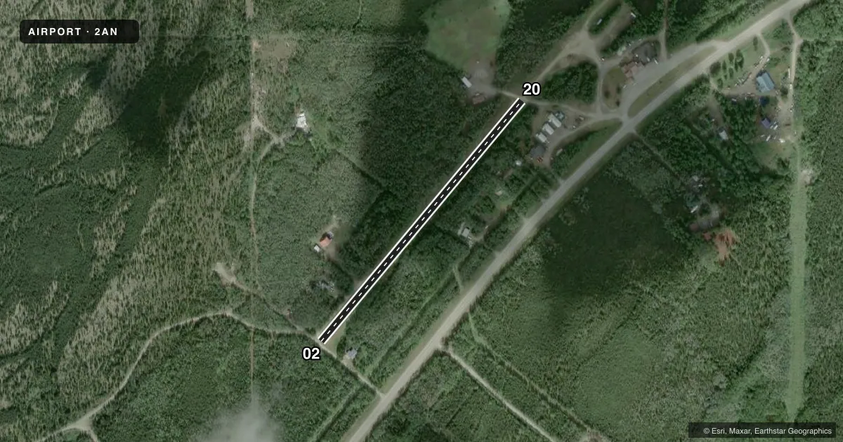
Full pagePattern entry · RWY 02
RIGHT TRAFFICAirport sketch
Runways drawn to scale from FAA survey coordinates, rendered over satellite imagery. Not for navigation.
Approaches & charts
Services on the field
Fuel grades, oxygen, maintenance, ramp storage and lighting — as declared to the FAA by the airport operator.
Fuel & services
- Fuel
- Not available
Ramp & ground
- Transient storage
- Not published
Fuel & FBOs
Cheapest 100LL and Jet A on the field and nearby. Always confirm with the FBO before taxi.
Airport notes
Surface conditions, obstructions, local procedures, lighting outages and other notes published with each FAA cycle.
General notes
- CTN - LDG AREA ALSO USED AS ROAD.
VFR map & nearby airports
VFR sectional. Tap any ICAO chip to open that airport.
Key facts · 2AN
Answer card- ICAO
- 2AN
- Name
- TISCHNER AIR
- Location
- ANDERSON, ALASKA
- Elevation
- 647 ft MSL
- Traffic pattern altitude
- 1,647 ft MSL (1,000 AGL)
- Control tower
- Non-towered (use CTAF)
- Total runways
- 1
- Longest runway
- 02/20 · 1,520 ft
- Published ILS approaches
- 0
- Published frequencies
- 1
- Magnetic variation
- –
- Current flight rules
- VFR
- Current wind
- 050° at 6 kt
- Favored runway now
- RWY 02
Tischner Air (2AN) sits in Anderson, Alaska. Field elevation is 647 ft MSL. The airport has one runway. Runway 02/20 is 1,520 ft long and surfaced with dirt. No control tower is published, so pilots should plan for self-announce traffic on CTAF 122.9.
No ILS approaches are published here. The pattern altitude is not published, so use the standard 1,000 ft AGL for light piston operations unless the current Chart Supplement says otherwise. That puts the traffic pattern at 1,647 ft MSL based on the listed field elevation. The published runway headings are magnetic in the airport data. Runway 02 is 39.7752651826817 degrees magnetic. Runway 20 is 219.775265182682 degrees magnetic.
There are no on-field FBOs listed. Check with the airport operator before arrival if you need local services. One published remark matters here. The landing area is also used as a road. Expect to be alert for surface use conflicts. Keep your scan tight on final, rollout and taxi. This is a short dirt strip in a remote Alaska setting. Plan conservatively for performance, surface condition and go-around margins.