METAR & TAF PAHV
PAHV does not publish a METAR.
Showing the nearest reporting station: PAIN (MC KINLEY NTL PARK) · 8.3 NM away. Conditions at PAHV may differ.
METAR · PAIN
Observed 18:56Z
PAIN 271856Z AUTO 00000KT 10SM FEW048 BKN060 OVC080 14/11 A2980 RMK AO2 RAE54 SLP097 P0001 T01390106 TSNO $
- Wind
- 000° @ 0 kt
- Visibility
- 10 SM
- Temp / Dew
- 14°C / 11°C
- Altimeter
- 29.80 inHg
- Clouds
- OVC
- Density alt
- 1,610 ft
- Ceiling
- 6,000 ft AGL
- Rules
- VFR
Airport info & contacts
Manager on record, flight service, ARTCC, attendance schedule and pattern altitude — published by the FAA and refreshed every 28 days.
Location
- From city
- 0 NM N
- VFR sectional
- ANCHORAGE
- ARTCC
- ZAN · ANCHORAGE
- NOTAM facility
- FAI (NOTAM-D)
Airport manager
- Name
- JASON LUDINGTON
- Phone
- 907-451-5280
- Address
- 2301 PEGER ROAD, FAIRBANKS AK 99709
Flight service · Hours
- FSS FAI
- FAIRBANKS907-474-07881-866-248-6516
- Attendance
- Unattended
Frequencies
Tap any row to copy the frequency to your clipboard.
Runways & pattern
Full pagePattern entry · RWY 15
RIGHT TRAFFICRunway end performance
| End | TORA | TODA | ASDA | LDA | VGSI | Approach lights | Obstruction |
|---|---|---|---|---|---|---|---|
| 15 | — | — | — | — | — | — | 25', trees, 200' from thr, 75' R of cntrln, slope 0 |
| 33 | — | — | — | — | — | — | 8', trees, 200' from thr, 115' R of cntrln, slope 0 |
Declared distances in feet. TORA = takeoff run available, TODA = takeoff distance, ASDA = accelerate-stop, LDA = landing distance.
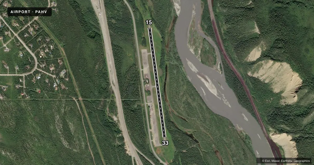
Airport sketch
Runways drawn to scale from FAA survey coordinates, rendered over satellite imagery. Not for navigation.
Approaches & charts
Services on the field
Fuel grades, oxygen, maintenance, ramp storage and lighting — as declared to the FAA by the airport operator.
Fuel & services
- Fuel
- 100LLA
- Oxygen (bottled)
- Not available
- Oxygen (bulk)
- Not available
- Other services
- CHTR
Ramp & ground
- Transient storage
- Tie-down
- Landing fee
- No fee published
- Customs
- Not available
- Lighting schedule
- SEE RMK
- Beacon schedule
- SS-SR
- Beacon
- White / Green (civil land)(WG)
- Wind indicator
- Lighted
- Segmented circle
- Yes
Fuel & FBOs
Cheapest 100LL and Jet A on the field and nearby. Always confirm with the FBO before taxi.
Airport notes
Surface conditions, obstructions, local procedures, lighting outages and other notes published with each FAA cycle.
General notes
- TURBULENT WINDS INVOF ARPT.
- RWY CONDITION NOT MONITORED; RECOMMEND VISUAL INSPECTION PRIOR TO LANDING.
- ARPT 2 SM SW OF USIBELLI MINE.
- RR TRACKS 700 FT FM THLD 20 FT ABOVE RWY ELEVATION.
- COLD TEMPERATURE AIRPORT. ALTITUDE CORRECTION REQUIRED AT OR BELOW -14C.
Lighting notes
- ACTVT MIRL RY 15/33 - CTAF.
Fuel notes
- AFULL SERVICE AV GAS AND JET A AVAILABLE DURING NORMAL BUSINESS HOURS MAY TO SEPTEMBER AND BY CALL OUT YEAR ROUND AND AFTER HOURS. CALL OUT FEE MAY APPLY, CALL: 907-683-2359.
Approach & departure obstructions
- 15RY 15/33 NSTD MKGS: THLD MKD BY PANELS, CONES & LIGHTS.
Other notes
- SEGMENTED CIRCLE 400 FT FM RY33 THLD 200 FT L OF CNTRLN.
- 15/33NUMEROUS CRACKS IN ASPH WITH WEEDS & GRASS GROWING THRU SFC UP TO 12 IN TALL.
VFR map & nearby airports
VFR sectional. Tap any ICAO chip to open that airport.
Key facts · PAHV
Answer card- ICAO
- PAHV
- Name
- HEALY RIVER
- Location
- HEALY, ALASKA
- Elevation
- 1,275 ft MSL
- Traffic pattern altitude
- 2,275 ft MSL (1,000 AGL)
- Control tower
- Non-towered (use CTAF)
- Total runways
- 1
- Longest runway
- 15/33 · 2,910 ft
- Published ILS approaches
- 0
- Published frequencies
- 1
- Magnetic variation
- 16°
- Current flight rules
- VFR
- Current wind
- 000° at 0 kt
- Favored runway now
- –
Healy River Airport sits in Healy, Alaska at 1,275 ft MSL. It has one runway, 15/33, which is 2,910 ft long and asphalt. There is no control tower. CTAF is 122.9. No ILS approaches are published here. The pattern altitude is not published, so use the standard 1,000 ft AGL for light piston operations unless the current Chart Supplement says otherwise.
This is a cold temperature airport. Altitude correction is required at or below minus 14 degrees Celsius. Runway condition is not monitored, so a visual check before landing is a good idea. The runway has nonstandard threshold markings on 15/33. The threshold is marked by panels, cones and lights. Medium intensity runway lights are activated by CTAF. Turbulent winds are common in the area. The airport is also 2 statute miles southwest of Usibelli Mine.
Fuel is available on the field. Full service avgas and Jet A are available during normal business hours from May to September. They are also available by call out year round and after hours. Call 907-683-2359 for current availability. There are no on-field FBOs listed. Expect a small-field Alaska environment. Check the current Chart Supplement for any local notes before you go.