METAR & TAF PAST
PAST does not publish a METAR.
Showing the nearest reporting station: PAIN (MC KINLEY NTL PARK) · 24.8 NM away. Conditions at PAST may differ.
METAR · PAIN
Observed 17:56Z
PAIN 271756Z AUTO 01008KT 10SM OVC080 10/09 A2978 RMK AO2 RAE39 SLP091 P0000 60008 T01000089 10122 20100 55001 TSNO $
- Wind
- 010° @ 8 kt
- Visibility
- 10 SM
- Temp / Dew
- 10°C / 9°C
- Altimeter
- 29.78 inHg
- Clouds
- OVC
- Density alt
- 2,561 ft
- Ceiling
- 8,000 ft AGL
- Rules
- VFR
Airport info & contacts
Manager on record, flight service, ARTCC, attendance schedule and pattern altitude — published by the FAA and refreshed every 28 days.
Location
- From city
- 0 NM N
- VFR sectional
- ANCHORAGE
- ARTCC
- ZAN · ANCHORAGE
- NOTAM facility
- ENA (NOTAM-D)
Airport manager
- Name
- JASON LUDINGTON
- Phone
- 907-451-5280
- Address
- 2301 PEGER ROAD, FAIRBANKS AK 99709
Flight service · Hours
- FSS ENA
- KENAI907-283-72111-866-864-1737
- Attendance
- Unattended
Frequencies
Tap any row to copy the frequency to your clipboard.
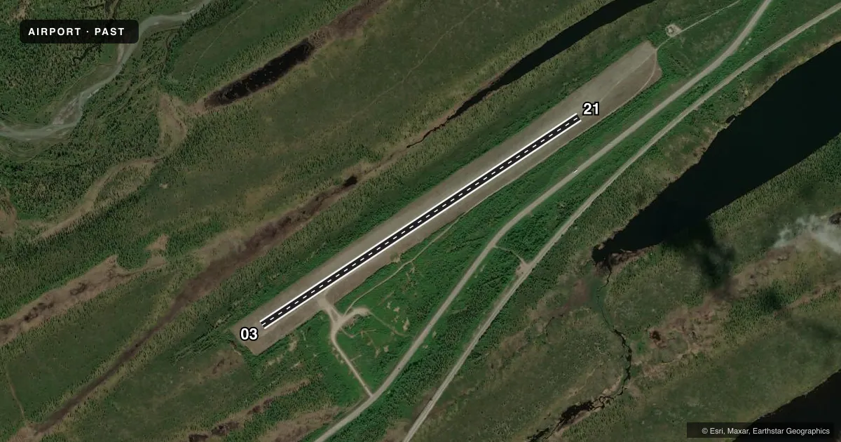
Runways & pattern
Full pagePattern entry · RWY 03
LEFT TRAFFICRunway end performance
| End | TORA | TODA | ASDA | LDA | VGSI | Approach lights | Obstruction |
|---|---|---|---|---|---|---|---|
| 03 | — | — | — | — | — | — | 7', brush, 0' from thr, 54' R of cntrln, slope 0 |
| 21 | — | — | — | — | — | — | 15', road, 0' from thr, 40' R of cntrln, slope 0 |
Declared distances in feet. TORA = takeoff run available, TODA = takeoff distance, ASDA = accelerate-stop, LDA = landing distance.
Airport sketch
Runways drawn to scale from FAA survey coordinates, rendered over satellite imagery. Not for navigation.
Approaches & charts
Services on the field
Fuel grades, oxygen, maintenance, ramp storage and lighting — as declared to the FAA by the airport operator.
Fuel & services
- Fuel
- Not available
Ramp & ground
- Transient storage
- Not published
- Landing fee
- No fee published
- Customs
- Not available
- Wind indicator
- Yes
- Segmented circle
- Yes
Fuel & FBOs
Cheapest 100LL and Jet A on the field and nearby. Always confirm with the FBO before taxi.
Airport notes
Surface conditions, obstructions, local procedures, lighting outages and other notes published with each FAA cycle.
General notes
- RCMND VISUAL INSP PRIOR TO LNDG.
- WINTER MAINT NA.
- WX CAMERA AVBL ON INTERNET AT HTTPS://WEATHERCAMS.FAA.GOV
Runway surface & condition
- 03/21SUBJ CROSSWINDS.
Approach & departure obstructions
- 03ROAD OBS ABEAM THR 40 FT L & PARL TO CNTRLN.
VFR map & nearby airports
VFR sectional. Tap any ICAO chip to open that airport.
Key facts · PAST
Answer card- ICAO
- PAST
- Name
- SUMMIT
- Location
- SUMMIT, ALASKA
- Elevation
- 2,409 ft MSL
- Traffic pattern altitude
- 3,409 ft MSL (1,000 AGL)
- Control tower
- Non-towered (use CTAF)
- Total runways
- 1
- Longest runway
- 03/21 · 3,814 ft
- Published ILS approaches
- 0
- Published frequencies
- 1
- Magnetic variation
- 26°
- Current flight rules
- VFR
- Current wind
- 010° at 8 kt
- Favored runway now
- RWY 03
Summit Airport sits in Summit, Alaska at 2,409 ft MSL. It has one runway. Runway 03/21 is 3,814 ft long and gravel. The field is not towered. CTAF is 122.9. No ILS approaches are published. The pattern altitude is not published, so use the standard 1,000 ft AGL for light piston operations unless the current Chart Supplement says otherwise.
This is a high-elevation Alaska strip, so plan for performance and weather with some margin. The published remarks call out crosswind sensitivity on the runway. They also recommend a visual inspection before landing. Winter maintenance is not available. There is also a road obstruction abeam the threshold on the 03 end, about 40 feet left of the centerline. Check the runway environment carefully on arrival.
No on-field FBOs are listed. If you need fuel or local handling, contact the airport operator directly before departure or call on CTAF for current availability. A weather camera is available online through the FAA weather camera system. For any current noise, access, or operational notes, verify the latest FAA Chart Supplement before you go.