METAR & TAF PAAH
PAAH does not publish a METAR.
Showing the nearest reporting station: PAMH (MINCHUMINA) · 40.5 NM away. Conditions at PAAH may differ.
METAR · PAMH
Observed 01:30Z
PAMH 280130Z AUTO 21010KT 10SM -RA BKN011 OVC050 13/13 A2981 RMK AO2 P0001 $
- Wind
- 210° @ 10 kt
- Visibility
- 10 SM
- Temp / Dew
- 13°C / 13°C
- Altimeter
- 29.81 inHg
- Clouds
- OVC
- Density alt
- 1,853 ft
- Ceiling
- 1,100 ft AGL
- Rules
- MVFR
Airport info & contacts
Manager on record, flight service, ARTCC, attendance schedule and pattern altitude — published by the FAA and refreshed every 28 days.
Location
- From city
- 2 NM NW
- VFR sectional
- ANCHORAGE
- ARTCC
- ZAN · ANCHORAGE
- NOTAM facility
- FAI (NOTAM-D)
Airport manager
- Name
- JASON LUDINGTON
- Phone
- 907-451-5280
- Address
- 2301 PEGER ROAD, FAIRBANKS AK 99709
Flight service · Hours
- FSS FAI
- FAIRBANKS907-474-07881-866-248-6516
- Attendance
- Unattended
Frequencies
Tap any row to copy the frequency to your clipboard.
Runways & pattern
Full pagePattern entry · RWY 10
LEFT TRAFFICRunway end performance
| End | TORA | TODA | ASDA | LDA | VGSI | Approach lights | Obstruction |
|---|---|---|---|---|---|---|---|
| 10 | — | — | — | — | — | — | 40', trees, 0' from thr, 110' R of cntrln, slope 0 |
| 28 | — | — | — | — | — | — | 45', trees, 0' from thr, 61' R of cntrln, slope 0 |
Declared distances in feet. TORA = takeoff run available, TODA = takeoff distance, ASDA = accelerate-stop, LDA = landing distance.
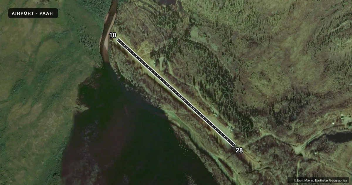
Airport sketch
Runways drawn to scale from FAA survey coordinates, rendered over satellite imagery. Not for navigation.
Approaches & charts
Services on the field
Fuel grades, oxygen, maintenance, ramp storage and lighting — as declared to the FAA by the airport operator.
Fuel & services
- Fuel
- Not available
Ramp & ground
- Transient storage
- Tie-down
- Landing fee
- No fee published
- Customs
- Not available
- Wind indicator
- Yes
- Segmented circle
- No
Fuel & FBOs
Cheapest 100LL and Jet A on the field and nearby. Always confirm with the FBO before taxi.
Airport notes
Surface conditions, obstructions, local procedures, lighting outages and other notes published with each FAA cycle.
General notes
- ROAD E OF RWY.
- CANYON RWY; EXP WIND SHEER.
- LMTD TSNT PRKG.
- RWY COND UNMNT; RCMD VISUAL INSP BFR LNDG.
- PVT ROTORWING NA EXC EMERG.
VFR map & nearby airports
VFR sectional. Tap any ICAO chip to open that airport.
Key facts · PAAH
Answer card- ICAO
- PAAH
- Name
- KANTISHNA
- Location
- KANTISHNA, ALASKA
- Elevation
- 1,578 ft MSL
- Traffic pattern altitude
- 2,578 ft MSL (1,000 AGL)
- Control tower
- Non-towered (use CTAF)
- Total runways
- 1
- Longest runway
- 10/28 · 1,887 ft
- Published ILS approaches
- 0
- Published frequencies
- 1
- Magnetic variation
- 25°
- Current flight rules
- MVFR
- Current wind
- 210° at 10 kt
- Favored runway now
- RWY 10
PAAH is the airport at Kantishna, Alaska. It sits at 1,578 ft MSL in a canyon setting, so expect terrain and wind effects to matter on arrival and departure. The field has one runway. Runway 10/28 is 1,887 ft long with a gravel-dirt surface. The runway headings are magnetic. There is no control tower. CTAF is 122.9.
No ILS approaches are published here. Pattern altitude is not published. Use the standard 1,000 ft AGL pattern unless the current Chart Supplement says otherwise. That puts the light aircraft pattern at 2,578 ft MSL based on the field elevation. The runway is in a canyon. Expect wind shear. A road lies east of the runway. Runway condition is unmonitored, so a visual inspection before landing is a smart move if conditions allow. Limited transient parking is available.
There are no on-field FBOs listed. Plan on confirming services with the airport operator or the FBO directly by phone before you go. Private rotorwing aircraft are not authorized except in emergencies. For a first-time pilot, the big items are the short gravel-dirt strip, the canyon winds and the lack of published instrument approach support. Check the current Chart Supplement and current field conditions before you launch.