METAR & TAF Z90
Z90 does not publish a METAR.
Showing the nearest reporting station: PAIN (MC KINLEY NTL PARK) · 37.7 NM away. Conditions at Z90 may differ.
METAR · PAIN
Observed 20:56Z
PAIN 272056Z AUTO VRB05KT 10SM -RA FEW038 BKN055 15/10 A2981 RMK AO2 RAB35 SLP100 P0000 60001 T01500100 53005 TSNO $
- Wind
- VAR @ 5 kt
- Visibility
- 10 SM
- Temp / Dew
- 15°C / 10°C
- Altimeter
- 29.81 inHg
- Clouds
- BKN
- Density alt
- 2,433 ft
- Ceiling
- 5,500 ft AGL
- Rules
- VFR
Airport info & contacts
Manager on record, flight service, ARTCC, attendance schedule and pattern altitude — published by the FAA and refreshed every 28 days.
Location
- From city
- 25 NM NE
- VFR sectional
- ANCHORAGE
- ARTCC
- ZAN · ANCHORAGE
- NOTAM facility
- FAI (NOTAM-D)
Airport manager
- Name
- SUPERINTENDENT, DENALI NAT. PARK
- Phone
- 907-683-9581
- Address
- PO BOX 9, DELALI PARK AK 99755
Flight service · Hours
- FSS FAI
- FAIRBANKS907-474-07881-866-248-6516
- Attendance
- Unattended
Frequencies
Tap any row to copy the frequency to your clipboard.
Runways & pattern
Full pagePattern entry · RWY 33
LEFT TRAFFICRunway end performance
| End | TORA | TODA | ASDA | LDA | VGSI | Approach lights | Obstruction |
|---|---|---|---|---|---|---|---|
| 15 | — | — | — | — | — | — | 30', tree, 0' from thr, 0' R of cntrln, slope 0 |
| 33 | — | — | — | — | — | — | 25', tree, 0' from thr, 37' R of cntrln, slope 0 |
Declared distances in feet. TORA = takeoff run available, TODA = takeoff distance, ASDA = accelerate-stop, LDA = landing distance.
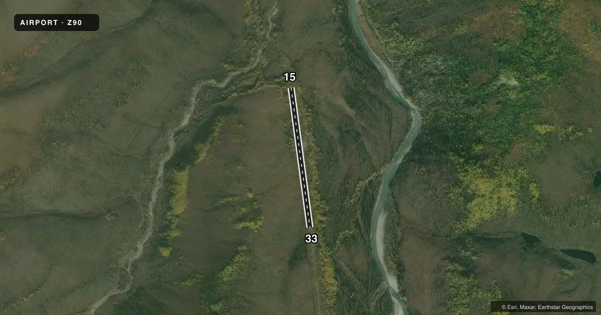
Airport sketch
Runways drawn to scale from FAA survey coordinates, rendered over satellite imagery. Not for navigation.
Approaches & charts
Services on the field
Fuel grades, oxygen, maintenance, ramp storage and lighting — as declared to the FAA by the airport operator.
Fuel & services
- Fuel
- Not available
- Oxygen (bottled)
- Not available
- Oxygen (bulk)
- Not available
- Airframe repair
- Not available
- Power plant repair
- Not available
Ramp & ground
- Transient storage
- Not published
- Landing fee
- No fee published
- Customs
- Not available
- Wind indicator
- No
- Segmented circle
- No
Fuel & FBOs
Cheapest 100LL and Jet A on the field and nearby. Always confirm with the FBO before taxi.
Airport notes
Surface conditions, obstructions, local procedures, lighting outages and other notes published with each FAA cycle.
General notes
- TREES & BRUSH ALONG BOTH SIDES OF RWY.
- COMMERCIAL OR BUSINESS USE OF THIS AIRSTRIP IS PROHIBITED EXCEPT UNDER PERMIT WITH THE NATIONAL PARK SERVICE.
- RY NOT MAINTAINED & UNMONITORED.
- PVT ROTORWING USE PROHIBITED, EXCP IN CASE OF EMERGS.
- WILDLIFE INVOF RY.
Runway surface & condition
- 15/331960 FT FM TREES TO TREES.
Other notes
- ESTABD PRIOR TO 1959.
- 15/33SURFACE COVERED WITH GRASS, SMALL SHRUBS.
VFR map & nearby airports
VFR sectional. Tap any ICAO chip to open that airport.
Key facts · Z90
Answer card- ICAO
- Z90
- Name
- STAMPEDE
- Location
- KANTISHNA, ALASKA
- Elevation
- 1,852 ft MSL
- Traffic pattern altitude
- 2,852 ft MSL (1,000 AGL)
- Control tower
- Non-towered (use CTAF)
- Total runways
- 1
- Longest runway
- 15/33 · 1,960 ft
- Published ILS approaches
- 0
- Published frequencies
- 1
- Magnetic variation
- 26°
- Current flight rules
- VFR
- Current wind
- 000° at 5 kt
- Favored runway now
- RWY 33
STAMPEDE sits in Kantishna, Alaska. The field elevation is 1,852 ft MSL. It has one runway. Runway 15/33 is 1,960 ft long and turf. The runway heading is magnetic. No ILS approaches are published. CTAF is 122.9. There is no control tower.
The published pattern altitude is not listed, so use the standard 1,000 ft AGL pattern only if that matches current local guidance and the current FAA Chart Supplement. The runway surface is grass with small shrubs. Trees and brush line both sides of the strip. Wildlife is also reported in the area. The runway length is described as 1,960 ft from trees to trees, so plan conservatively.
This is not a maintained or monitored runway. Commercial or business use is prohibited unless you have a permit with the National Park Service. Private rotorwing use is also prohibited except for emergencies. There are no on-field FBOs listed. Check the current FAA Chart Supplement and contact the airport operator before you go. In a place like this, the main issues are surface condition, obstacle clearance and wildlife on or near the runway.