METAR & TAF PAAF
PAAF does not publish a METAR.
Showing the nearest reporting station: PANN (NENANA MUNI) · 36.9 NM away. Conditions at PAAF may differ.
METAR · PANN
Observed 11:53Z
PANN 271153Z AUTO 00000KT 10SM BKN090 OVC110 16/14 A2971 RMK AO2 SLP064 60000 T01560139 10194 20150 51002 TSNO $
- Wind
- 000° @ 0 kt
- Visibility
- 10 SM
- Temp / Dew
- 16°C / 14°C
- Altimeter
- 29.71 inHg
- Clouds
- OVC
- Density alt
- 1,000 ft
- Ceiling
- 9,000 ft AGL
- Rules
- VFR
Airport info & contacts
Manager on record, flight service, ARTCC, attendance schedule and pattern altitude — published by the FAA and refreshed every 28 days.
Location
- From city
- 1 NM E
- VFR sectional
- FAIRBANKS
- ARTCC
- ZAN · ANCHORAGE
- NOTAM facility
- FAI (NOTAM-D)
Airport manager
- Name
- JEFF RUSSELL
- Phone
- 907-451-2207
- Address
- 2301 PEGER ROAD, FAIRBANKS AK 99709
Flight service · Hours
- FSS FAI
- FAIRBANKS907-474-07881-866-248-6516
- Attendance
- Unattended
Frequencies
Tap any row to copy the frequency to your clipboard.
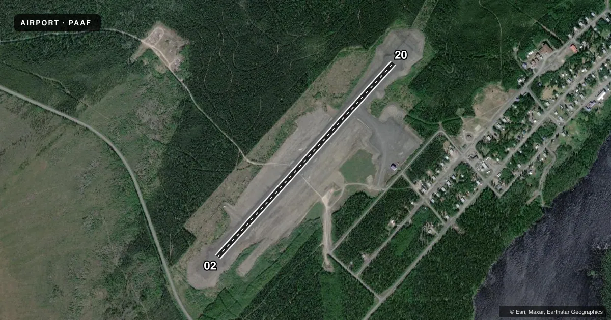
Runways & pattern
Full pagePattern entry · RWY 02
LEFT TRAFFICRunway end performance
| End | TORA | TODA | ASDA | LDA | VGSI | Approach lights | Obstruction |
|---|---|---|---|---|---|---|---|
| 02 | — | — | — | — | PAPI 4-box left(3°) | — | — |
| 20 | — | — | — | — | PAPI 4-box left(3°) | — | — |
Declared distances in feet. TORA = takeoff run available, TODA = takeoff distance, ASDA = accelerate-stop, LDA = landing distance.
Airport sketch
Runways drawn to scale from FAA survey coordinates, rendered over satellite imagery. Not for navigation.
Approaches & charts
Services on the field
Fuel grades, oxygen, maintenance, ramp storage and lighting — as declared to the FAA by the airport operator.
Fuel & services
- Fuel
- Not available
Ramp & ground
- Transient storage
- Not published
- Landing fee
- No fee published
- Customs
- Not available
- Lighting schedule
- SEE RMK
- Beacon schedule
- SEE RMK
- Beacon
- White / Green (civil land)(WG)
- Wind indicator
- Lighted
- Segmented circle
- Yes
Fuel & FBOs
Cheapest 100LL and Jet A on the field and nearby. Always confirm with the FBO before taxi.
Airport notes
Surface conditions, obstructions, local procedures, lighting outages and other notes published with each FAA cycle.
General notes
- EXP IREG WINDS.
- RWY COND UNMNT; RCMD VISUAL INSP BFR LNDG.
- WINTER SNOW REMOVAL OPS - MNT CTAF.
- WX CAMERA AVBL ON INTERNET AT HTTPS://WEATHERCAMS.FAA.GOV
- WATERFOWL INVOF RWY APCHS.
Lighting notes
- ACTVT ROTG BCN- CTAF.
- ACTVT MIRL RWY 02/20; PAPI & REIL RWY 02 & 20 - CTAF.
VFR map & nearby airports
VFR sectional. Tap any ICAO chip to open that airport.
Key facts · PAAF
Answer card- ICAO
- PAAF
- Name
- MINTO AL WRIGHT
- Location
- MINTO, ALASKA
- Elevation
- 499.8 ft MSL
- Traffic pattern altitude
- 1,499.8 ft MSL (1,000 AGL)
- Control tower
- Non-towered (use CTAF)
- Total runways
- 1
- Longest runway
- 02/20 · 3,400 ft
- Published ILS approaches
- 0
- Published frequencies
- 1
- Magnetic variation
- 27°
- Current flight rules
- VFR
- Current wind
- 000° at 0 kt
- Favored runway now
- –
Minto Al Wright Airport sits in Minto, Alaska at 499.8 ft MSL. It has one runway. Runway 02/20 is 3,400 ft long and gravel. There is no control tower. CTAF is 122.9. No ILS approaches are published here.
For pattern work, use the published pattern altitude if you have it from the current Chart Supplement. The facts provided here do not give a published pattern altitude, so verify that before you fly. The runway headings are magnetic. The field has medium intensity runway lights on 02/20. The PAPI and runway end identifier lights are tied to CTAF activation. The rotating beacon is also CTAF activated.
There are no on-field FBOs listed. Plan on self-sufficiency and confirm current services with the airport operator before arrival. Published remarks also note winter snow removal activity on CTAF, waterfowl near the runway approaches and an unmonitored runway condition. A visual check before landing is a good idea. Expect irregular winds here. A weather camera is available online for a current look at the field.