METAR & TAF PFMP
PFMP does not publish a METAR.
Showing the nearest reporting station: PATA (RALPH M CALHOUN MEML) · 53.2 NM away. Conditions at PFMP may differ.
METAR · PATA
Observed 18:52Z
PATA 271852Z 10005KT 10SM FEW080CB BKN100 20/13 A2973 RMK AO2 SLP070 CB ALQDS T02000133
- Wind
- 100° @ 5 kt
- Visibility
- 10 SM
- Temp / Dew
- 20°C / 13°C
- Altimeter
- 29.73 inHg
- Clouds
- BKN
- Density alt
- 1,216 ft
- Ceiling
- 10,000 ft AGL
- Rules
- VFR
Airport info & contacts
Manager on record, flight service, ARTCC, attendance schedule and pattern altitude — published by the FAA and refreshed every 28 days.
Location
- From city
- 1 NM E
- VFR sectional
- FAIRBANKS
- ARTCC
- ZAN · ANCHORAGE
- NOTAM facility
- FAI (NOTAM-D)
Airport manager
- Name
- JASON LUDINGTON
- Phone
- (907) 451-5280
- Address
- 2301 PEGER RD, FAIRBANKS AK 99709
Flight service · Hours
- FSS FAI
- FAIRBANKS907-474-07881-866-248-6516
- Attendance
- Unattended
Frequencies
Tap any row to copy the frequency to your clipboard.
Runways & pattern
Full pagePattern entry · RWY 11
LEFT TRAFFICRunway end performance
| End | TORA | TODA | ASDA | LDA | VGSI | Approach lights | Obstruction |
|---|---|---|---|---|---|---|---|
| 11 | — | — | — | — | PAPI 4-box left(3°) | — | 22', trees, 365' from thr, 170' R of cntrln, slope 16 |
| 29 | — | — | — | — | — | — | 8', brush, 40' from thr, 90' R of cntrln, slope 5 |
Declared distances in feet. TORA = takeoff run available, TODA = takeoff distance, ASDA = accelerate-stop, LDA = landing distance.
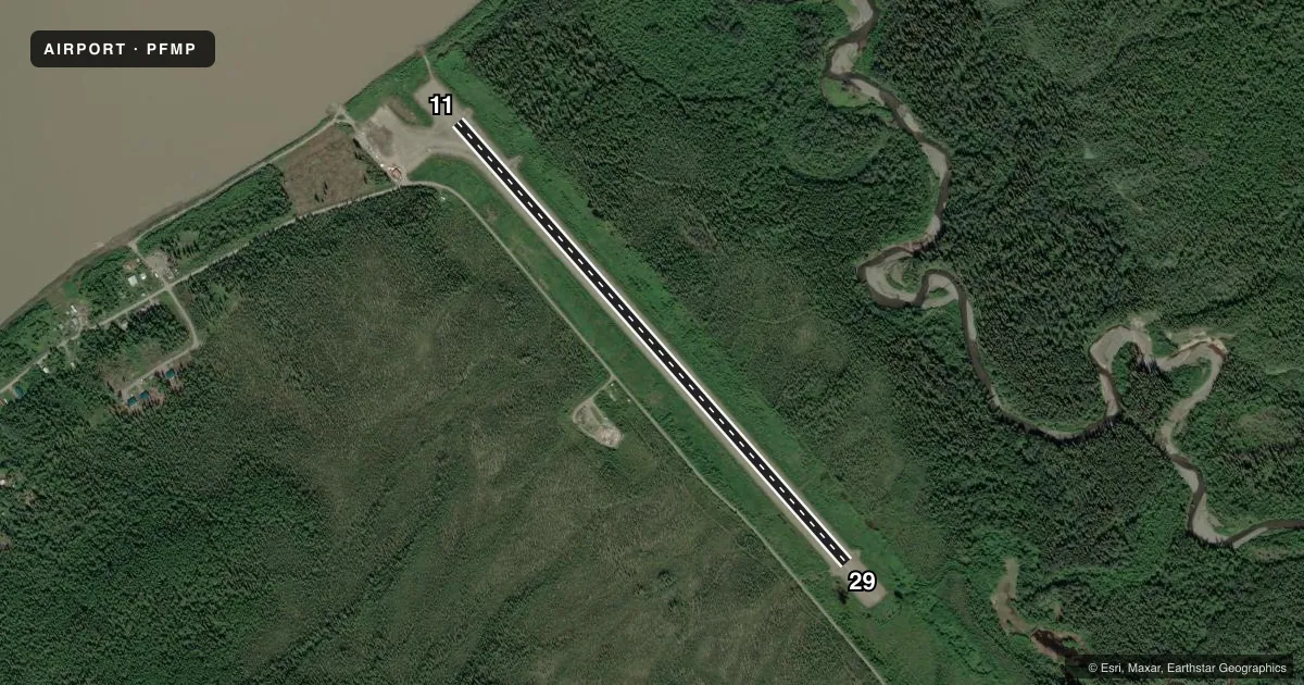
Airport sketch
Runways drawn to scale from FAA survey coordinates, rendered over satellite imagery. Not for navigation.
Approaches & charts
Services on the field
Fuel grades, oxygen, maintenance, ramp storage and lighting — as declared to the FAA by the airport operator.
Fuel & services
- Fuel
- Not available
- Oxygen (bottled)
- Not available
- Oxygen (bulk)
- Not available
- Airframe repair
- Not available
- Power plant repair
- Not available
Ramp & ground
- Transient storage
- Not published
- Landing fee
- No fee published
- Customs
- Not available
- Lighting schedule
- SEE RMK
- Beacon schedule
- SEE RMK
- Beacon
- White / Green (civil land)(WG)
- Wind indicator
- Lighted
- Segmented circle
- Yes
Fuel & FBOs
Cheapest 100LL and Jet A on the field and nearby. Always confirm with the FBO before taxi.
Airport notes
Surface conditions, obstructions, local procedures, lighting outages and other notes published with each FAA cycle.
General notes
- FREQUENT CROSSWINDS & TURBULENCE FM EACH RWY END.
- RWY SLOPES GRADUALLY UPHILL FROM RIVER.
- SNOW REMOVAL OPS DURING WINTER - MONITOR CTAF.
- RWY CONDITION NOT MONITORED; RECOMMEND VISUAL INSPECTION PRIOR TO LANDING.
Lighting notes
- ACTVT ROTATING BEACON - CTAF.
- ACTVT MIRL RY 11/29; REIL & PAPI RY 11 - CTAF.
VFR map & nearby airports
VFR sectional. Tap any ICAO chip to open that airport.
Key facts · PFMP
Answer card- ICAO
- PFMP
- Name
- RAMPART
- Location
- RAMPART, ALASKA
- Elevation
- 306.7 ft MSL
- Traffic pattern altitude
- 1,306.7 ft MSL (1,000 AGL)
- Control tower
- Non-towered (use CTAF)
- Total runways
- 1
- Longest runway
- 11/29 · 3,520 ft
- Published ILS approaches
- 0
- Published frequencies
- 1
- Magnetic variation
- 24°
- Current flight rules
- VFR
- Current wind
- 100° at 5 kt
- Favored runway now
- RWY 11
Rampart Airport sits in Rampart, Alaska. Field elevation is 306.7 ft MSL. The airport has one runway. Runway 11/29 is 3,520 ft long and surfaced with gravel. There is no control tower. CTAF is 122.9.
No ILS approaches are published here. Pattern altitude is not published, so use the standard 1,000 ft AGL for light piston operations unless the current FAA Chart Supplement says otherwise. The runway lighting is activated by CTAF. That includes the rotating beacon. Runway 11 also has runway end identifier lights and PAPI activated by CTAF.
The published remarks matter here. Winter snow removal takes place. Frequent crosswinds and turbulence occur from each runway end. The runway condition is not monitored, so a visual inspection before landing is a good habit. The runway also slopes gradually uphill from the river. That can affect your landing picture and rollout, especially if you are new to the strip.
There are no on-field FBOs listed in the facts. Check with the airport operator or the FBO directly by phone before arrival if you need services. For any current noise, surface, or operational changes, verify the latest FAA Chart Supplement before you go.