METAR & TAF PFSV
PFSV does not publish a METAR.
Showing the nearest reporting station: PAPR (PROSPECT CREEK) · 61.2 NM away. Conditions at PFSV may differ.
METAR · PAPR
Observed 16:45Z
PAPR 161645Z 18006KT 15SM OVC025 11/ A2982
- Wind
- 180° @ 6 kt
- Visibility
- 15 SM
- Temp / Dew
- —
- Altimeter
- 29.82 inHg
- Clouds
- OVC
- Density alt
- —
- Ceiling
- 2,500 ft AGL
- Rules
- MVFR
Airport info & contacts
Manager on record, flight service, ARTCC, attendance schedule and pattern altitude — published by the FAA and refreshed every 28 days.
Location
- From city
- 1 NM NNE
- VFR sectional
- FAIRBANKS
- ARTCC
- ZAN · ANCHORAGE
- NOTAM facility
- FAI (NOTAM-D)
Airport manager
- Name
- JASON LUDINGTON
- Phone
- 907-451-5280
- Address
- 2301 PEGER RD, FAIRBANKS AK 99709
Flight service · Hours
- FSS FAI
- FAIRBANKS907-474-07881-866-248-6516
- Attendance
- Unattended
Frequencies
Tap any row to copy the frequency to your clipboard.
Runways & pattern
Full pagePattern entry · RWY 23
LEFT TRAFFICRunway end performance
| End | TORA | TODA | ASDA | LDA | VGSI | Approach lights | Obstruction |
|---|---|---|---|---|---|---|---|
| 05 | — | — | — | — | PAPI 4-box left(3°) | — | 3', trees, 50' R of cntrln |
| 23 | — | — | — | — | PAPI 4-box left(3°) | — | 3', trees, 50' R of cntrln |
Declared distances in feet. TORA = takeoff run available, TODA = takeoff distance, ASDA = accelerate-stop, LDA = landing distance.
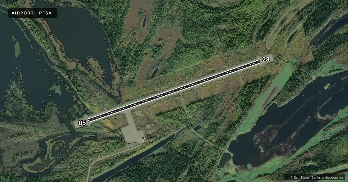
Airport sketch
Runways drawn to scale from FAA survey coordinates, rendered over satellite imagery. Not for navigation.
Approaches & charts
Services on the field
Fuel grades, oxygen, maintenance, ramp storage and lighting — as declared to the FAA by the airport operator.
Fuel & services
- Fuel
- Not available
Ramp & ground
- Transient storage
- Not published
- Landing fee
- No fee published
- Customs
- Not available
- Lighting schedule
- SEE RMK
- Beacon schedule
- SEE RMK
- Beacon
- White / Green (civil land)(WG)
- Wind indicator
- Lighted
- Segmented circle
- Yes
Fuel & FBOs
Cheapest 100LL and Jet A on the field and nearby. Always confirm with the FBO before taxi.
Airport notes
Surface conditions, obstructions, local procedures, lighting outages and other notes published with each FAA cycle.
General notes
- RWY COND UNMNT; RCMD VISUAL INSP BFR LNDG.
- SNOW REMOVAL OPS - CTAF.
- CLSD RWY 1 NM W.
Lighting notes
- ACTVT ROTG BEACON - CTAF.
- ACTVT REIL RWY 05 & 23; PAPI RWY 05 & 23; MIRL RWY 05/23 - CTAF.
Approach & departure obstructions
- 05LGTS & CONES.
- 23LGTS & CONES.
- 05CTLG OBSTN EXCEEDS 45 DEG SLOPE.
VFR map & nearby airports
VFR sectional. Tap any ICAO chip to open that airport.
Key facts · PFSV
Answer card- ICAO
- PFSV
- Name
- STEVENS VILLAGE
- Location
- STEVENS VILLAGE, ALASKA
- Elevation
- 328.3 ft MSL
- Traffic pattern altitude
- 1,328.3 ft MSL (1,000 AGL)
- Control tower
- Non-towered (use CTAF)
- Total runways
- 1
- Longest runway
- 05/23 · 4,000 ft
- Published ILS approaches
- 0
- Published frequencies
- 1
- Magnetic variation
- 22°
- Current flight rules
- MVFR
- Current wind
- 180° at 6 kt
- Favored runway now
- RWY 23
Stevens Village Airport (PFSV) sits in Stevens Village, Alaska. Field elevation is 328.3 ft MSL. The airport has one runway. Runway 05/23 is 4,000 ft long and surfaced in gravel-dirt. There is no control tower. CTAF is 122.9.
No ILS approaches are published here. The pattern altitude is not published, so use the standard 1,000 ft AGL for light piston operations unless the current Chart Supplement says otherwise. The published remarks matter here. Runway end identifier lights are installed on 05 and 23. Medium intensity runway lights are installed on 05/23. PAPI is also installed on both ends. The rotating beacon is activated. Use CTAF for lighting and snow removal coordination.
Plan for a visual check before landing. Runway condition is unmonitored. The Chart Supplement also notes an obstruction beyond the runway 05 end that exceeds a 45 degree slope. A closed runway sits 1 NM west. There are no on-field FBOs listed, so verify services with the airport operator or the FBO directly by phone before you go. In this part of Alaska, runway condition and winter ops deserve extra attention. Check the current Chart Supplement before departure for any updates.