METAR & TAF 4AK
4AK does not publish a METAR.
Showing the nearest reporting station: PAFA (FAIRBANKS INTL) · 44.0 NM away. Conditions at 4AK may differ.
METAR · PAFA
Observed 22:53Z
PAFA 262253Z 15005KT 10SM SCT075 SCT120 BKN200 26/08 A2969
- Wind
- 150° @ 5 kt
- Visibility
- 10 SM
- Temp / Dew
- 26°C / 8°C
- Altimeter
- 29.69 inHg
- Clouds
- BKN
- Density alt
- 2,135 ft
- Ceiling
- 20,000 ft AGL
- Rules
- VFR
Airport info & contacts
Manager on record, flight service, ARTCC, attendance schedule and pattern altitude — published by the FAA and refreshed every 28 days.
Location
- From city
- 0 NM E
- VFR sectional
- FAIRBANKS
- ARTCC
- ZAN · ANCHORAGE
- NOTAM facility
- FAI (NOTAM-D)
Airport manager
- Name
- JEFF RUSSELL
- Phone
- 907-451-2207
- Address
- 2301 PEGER RD, FAIRBANKS AK 99709
Flight service · Hours
- FSS FAI
- FAIRBANKS907-474-07881-866-248-6516
- Attendance
- Unattended
Frequencies
Tap any row to copy the frequency to your clipboard.
Runways & pattern
Full pagePattern entry · RWY 15
LEFT TRAFFICRunway end performance
| End | TORA | TODA | ASDA | LDA | VGSI | Approach lights | Obstruction |
|---|---|---|---|---|---|---|---|
| 15 | — | — | — | — | — | — | 7', trees, 10' from thr, 124' R of cntrln, slope 1 |
| 33 | — | — | — | — | — | — | 18', trees, 12' from thr, 122' R of cntrln, slope 0 |
Declared distances in feet. TORA = takeoff run available, TODA = takeoff distance, ASDA = accelerate-stop, LDA = landing distance.
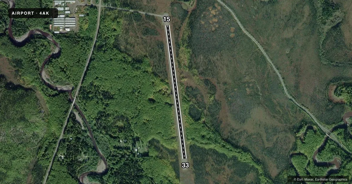
Airport sketch
Runways drawn to scale from FAA survey coordinates, rendered over satellite imagery. Not for navigation.
Approaches & charts
Services on the field
Fuel grades, oxygen, maintenance, ramp storage and lighting — as declared to the FAA by the airport operator.
Fuel & services
- Fuel
- Not available
- Oxygen (bottled)
- Not available
- Oxygen (bulk)
- Not available
- Airframe repair
- Not available
- Power plant repair
- Not available
Ramp & ground
- Transient storage
- Not published
- Landing fee
- No fee published
- Customs
- Not available
- Wind indicator
- Yes
- Segmented circle
- No
Fuel & FBOs
Cheapest 100LL and Jet A on the field and nearby. Always confirm with the FBO before taxi.
Airport notes
Surface conditions, obstructions, local procedures, lighting outages and other notes published with each FAA cycle.
General notes
- RY NOT MAINTAINED & CONDITION NOT MONITORED, RECOMMEND VISUAL INSPECTION PRIOR TO LANDING.
- WX CAMERA AVBL ON INTERNET AT HTTPS://WEATHERCAMS.FAA.GOV
- BE ALERT: -WATCH FOR FREQUENT HELICOPTER TRAFFIC FROM ADJACENT WORK CAMP.
Approach & departure obstructions
- 15RYS 15 & 33 NSTD MKGS; RY EDGES MKD WITH CONES.
VFR map & nearby airports
VFR sectional. Tap any ICAO chip to open that airport.
Key facts · 4AK
Answer card- ICAO
- 4AK
- Name
- LIVENGOOD CAMP
- Location
- LIVENGOOD, ALASKA
- Elevation
- 427.5 ft MSL
- Traffic pattern altitude
- 1,427.5 ft MSL (1,000 AGL)
- Control tower
- Non-towered (use CTAF)
- Total runways
- 1
- Longest runway
- 15/33 · 3,000 ft
- Published ILS approaches
- 0
- Published frequencies
- 1
- Magnetic variation
- 27°
- Current flight rules
- VFR
- Current wind
- 150° at 5 kt
- Favored runway now
- RWY 15
Livengood Camp is in Livengood, Alaska. The field elevation is 427.5 ft MSL. It has one runway, 15/33, which is 3,000 ft long on gravel. This is an uncontrolled airport with no tower. CTAF is 122.9.
No ILS approaches are published here. The pattern altitude is not published. Use the standard 1,000 ft AGL pattern for light piston operations unless the current Chart Supplement says otherwise. The runway is not maintained. Condition is not monitored, so a close visual check before landing is a good idea. Runways 15 and 33 also have nonstandard markings. Runway edges are marked with cones.
Watch for frequent helicopter traffic from the adjacent work camp. That matters on arrival and departure, especially if you are planning a low approach or a tight pattern. A weather camera is available online through FAA weather cameras, which can help with a quick look before you launch. There are no on-field FBOs listed. Check with the airport operator or the current FAA Chart Supplement before you go if you need current field details or services.