METAR & TAF 20K
20K does not publish a METAR.
Showing the nearest reporting station: PANN (NENANA MUNI) · 51.5 NM away. Conditions at 20K may differ.
METAR · PANN
Observed 19:53Z
PANN 271953Z AUTO 00000KT 10SM -RA FEW037 BKN060 OVC080 18/15 A2973 RMK AO2 RAB11E20B52 SLP070 P0000 T01780150 TSNO $
- Wind
- 000° @ 0 kt
- Visibility
- 10 SM
- Temp / Dew
- 18°C / 15°C
- Altimeter
- 29.73 inHg
- Clouds
- OVC
- Density alt
- 2,550 ft
- Ceiling
- 6,000 ft AGL
- Rules
- VFR
Airport info & contacts
Manager on record, flight service, ARTCC, attendance schedule and pattern altitude — published by the FAA and refreshed every 28 days.
Location
- From city
- 1 NM S
- VFR sectional
- FAIRBANKS
- ARTCC
- ZAN · ANCHORAGE
- NOTAM facility
- FAI (NOTAM-D)
Airport manager
- Name
- STATE OF ALASKA, DNR, DMLW
- Phone
- 907-451-2740
- Address
- 3700 AIRPORT WAY, FAIRBANKS AK 99709-4699
Flight service · Hours
- FSS FAI
- FAIRBANKS907-474-07881-866-248-6516
- Attendance
- Unattended
Frequencies
Tap any row to copy the frequency to your clipboard.
Runways & pattern
Full pagePattern entry · RWY 16
LEFT TRAFFICRunway end performance
| End | TORA | TODA | ASDA | LDA | VGSI | Approach lights | Obstruction |
|---|---|---|---|---|---|---|---|
| 16 | — | — | — | — | — | — | 63', trees, 0' from thr, 55' R of cntrln, slope 0 |
| 34 | — | — | — | — | — | — | 56', trees, 0' from thr, 0' R of cntrln, slope 0 |
Declared distances in feet. TORA = takeoff run available, TODA = takeoff distance, ASDA = accelerate-stop, LDA = landing distance.
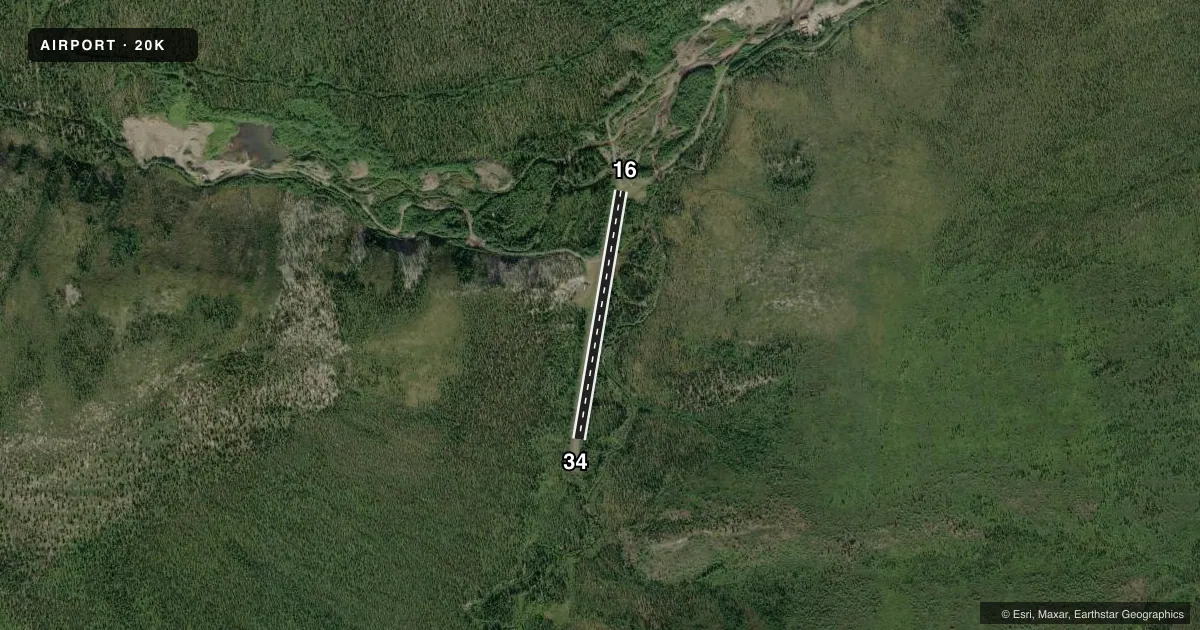
Airport sketch
Runways drawn to scale from FAA survey coordinates, rendered over satellite imagery. Not for navigation.
Approaches & charts
Services on the field
Fuel grades, oxygen, maintenance, ramp storage and lighting — as declared to the FAA by the airport operator.
Fuel & services
- Fuel
- Not available
- Oxygen (bottled)
- Not available
- Oxygen (bulk)
- Not available
- Airframe repair
- Not available
- Power plant repair
- Not available
Ramp & ground
- Transient storage
- Not published
- Landing fee
- No fee published
- Customs
- Not available
- Wind indicator
- Yes
- Segmented circle
- No
Fuel & FBOs
Cheapest 100LL and Jet A on the field and nearby. Always confirm with the FBO before taxi.
Airport notes
Surface conditions, obstructions, local procedures, lighting outages and other notes published with each FAA cycle.
General notes
- RY NOT MAINTAINED RECOMMEND VISUAL INSPECTION PRIOR TO LDG.
- RY 16/34 LOCATED IN MTN RAVINE, EXPECT TURBULENT WINDS.
- STEEP TURNING APPROACH REQUIRED EITHER DIRECTION.
- NO LINE OF SIGHT BTN RY ENDS.
- RY SUITABLE ONLY FOR HIGH-WING, CONVENTIONAL GEARED ACFT, DUE TO BRUSH ENCHROACHMENT.
- ROAD ALONG THE EAST SIDE OF RUNWAY
Runway surface & condition
- 16/34SLOPES DOWN TOWARD NORTH 3%.
Approach & departure obstructions
- 16NUMEROUS TREES SURROUND RY 16 THLD.
- 34TREES AND BRUSH SURROUND RY 34 THLD.
Other notes
- ESABD PRIOR TO 1959.
- 16/34SOFT WHEN WET; TREES UP TO 60 INCH, BRUSH & 36 INCH GRASS ON ENTIRE SFC.
VFR map & nearby airports
VFR sectional. Tap any ICAO chip to open that airport.
Key facts · 20K
Answer card- ICAO
- 20K
- Name
- QUAIL CREEK
- Location
- QUAIL CREEK, ALASKA
- Elevation
- 1,576 ft MSL
- Traffic pattern altitude
- 2,576 ft MSL (1,000 AGL)
- Control tower
- Non-towered (use CTAF)
- Total runways
- 1
- Longest runway
- 16/34 · 1,650 ft
- Published ILS approaches
- 0
- Published frequencies
- 1
- Magnetic variation
- 27°
- Current flight rules
- VFR
- Current wind
- 000° at 0 kt
- Favored runway now
- –
Quail Creek Airport (20K) is in Quail Creek, Alaska. The field elevation is 1,576 ft MSL. It has one runway, 16/34, which is 1,650 ft long. The airport is not towered. CTAF is 122.9. No ILS approaches are published here. Pattern altitude is not published, so use the standard 1,000 ft AGL for light piston operations unless the current FAA Chart Supplement says otherwise.
The runway surface is turf-gravel. The published remarks matter here. The runway is not maintained. A visual inspection before landing is recommended. The surface can be soft when wet. Trees, brush and tall grass cover the runway area. Runway 16/34 sits in a mountain ravine. Expect turbulent winds. A steep turning approach is required in either direction. There is no line of sight between runway ends. The runway slopes down toward the north by 3 percent. Trees surround the threshold of runway 16. Trees and brush surround the threshold of runway 34.
There are no on-field FBOs listed. Plan on self-sufficiency and verify current field conditions with the airport operator or by calling on CTAF before you go. The field was established before 1959. The runway is described as suitable only for high-wing, conventional geared aircraft due to brush encroachment. That is a strong clue to treat this as a short, rough and terrain-sensitive strip.