METAR & TAF PAPR
Current METAR
Observed 16:45Z
PAPR 161645Z 18006KT 15SM OVC025 11/ A2982
- Wind
- 180° @ 6 kt
- Visibility
- 15 SM
- Temp / Dew
- —
- Altimeter
- 29.82 inHg
- Clouds
- OVC
- Density alt
- —
- Ceiling
- 2,500 ft AGL
- Rules
- MVFR
Airport info & contacts
Manager on record, flight service, ARTCC, attendance schedule and pattern altitude — published by the FAA and refreshed every 28 days.
Location
- From city
- 3 NM NE
- VFR sectional
- FAIRBANKS
- ARTCC
- ZAN · ANCHORAGE
- NOTAM facility
- PPC (NOTAM-D)
Airport manager
- Name
- RENIER SWART
- Phone
- 907-787-8959
- Address
- P.O. BOX 196660, MS 530B, MILTON CROSS, ANCHORAGE AK 99512
Flight service · Hours
- FSS FAI
- FAIRBANKS907-474-07881-866-248-6516
- Attendance
- Unattended
Frequencies
Tap any row to copy the frequency to your clipboard.
Runways & pattern
Full pagePattern entry · RWY 19
LEFT TRAFFICRunway end performance
| End | TORA | TODA | ASDA | LDA | VGSI | Approach lights | Obstruction |
|---|---|---|---|---|---|---|---|
| 01 | — | — | — | — | PAPI 2-box left(3°) | — | 7', brush, 22' from thr, 120' R of cntrln, slope 3 |
| 19 | — | — | — | — | PAPI 2-box left(3°) | — | — |
Declared distances in feet. TORA = takeoff run available, TODA = takeoff distance, ASDA = accelerate-stop, LDA = landing distance.
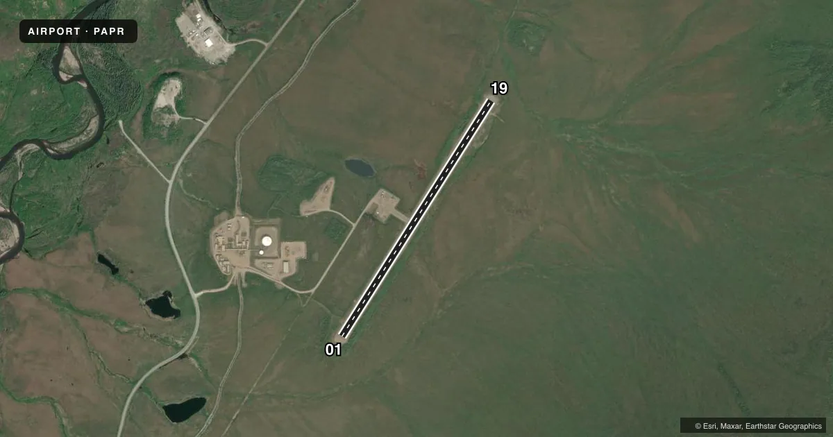
Airport sketch
Runways drawn to scale from FAA survey coordinates, rendered over satellite imagery. Not for navigation.
Approaches & charts
Services on the field
Fuel grades, oxygen, maintenance, ramp storage and lighting — as declared to the FAA by the airport operator.
Fuel & services
- Fuel
- Not available
Ramp & ground
- Transient storage
- Not published
- Landing fee
- No fee published
- Customs
- Not available
- Lighting schedule
- SEE RMK
- Beacon schedule
- SEE RMK
- Beacon
- White / Green (civil land)(WG)
- Wind indicator
- Lighted
- Segmented circle
- Yes
Fuel & FBOs
Cheapest 100LL and Jet A on the field and nearby. Always confirm with the FBO before taxi.
Airport notes
Surface conditions, obstructions, local procedures, lighting outages and other notes published with each FAA cycle.
General notes
- LTD SNOW REMOVAL.
- COLD TEMPERATURE AIRPORT. ALTITUDE CORRECTION REQUIRED AT OR BELOW -27C.
- RWY COND UNMNT; RCMD VISUAL INSP PRIOR TO USE.
Lighting notes
- LCTD ON ALYESKA FLT ADZY BLDG: ON WHEN MANNED.
- ACVT REIL RWY 01 & 19; MIRL RWY 01/19 - CTAF.
VFR map & nearby airports
VFR sectional. Tap any ICAO chip to open that airport.
Key facts · PAPR
Answer card- ICAO
- PAPR
- Name
- PROSPECT CREEK
- Location
- PROSPECT CREEK, ALASKA
- Elevation
- 1,094.7 ft MSL
- Traffic pattern altitude
- 2,094.7 ft MSL (1,000 AGL)
- Control tower
- Non-towered (use CTAF)
- Total runways
- 1
- Longest runway
- 01/19 · 4,968 ft
- Published ILS approaches
- 0
- Published frequencies
- 1
- Magnetic variation
- 21°
- Current flight rules
- MVFR
- Current wind
- 180° at 6 kt
- Favored runway now
- RWY 19
Prospect Creek Airport sits in Prospect Creek, Alaska. Field elevation is 1,094.7 ft MSL. The airport has one runway. Runway 01/19 is 4,968 ft of gravel, which is the longest runway on the field. There is no control tower. CTAF is 122.9.
No ILS approaches are published here. Pattern altitude is not published, so plan on the standard 1,000 ft AGL for light piston traffic unless the current FAA Chart Supplement says otherwise. The published remarks matter here. This is a cold temperature airport. Altitude correction is required at or below minus 27 degrees Celsius. Runway condition is unmonitored, so a visual inspection before use is a good idea. Limited snow removal is available. The beacon is on the Alyeska Flight Advisory Building and is on when manned. Runway end identifier lights are installed on both ends. Medium intensity runway lights on 01/19 are controlled by CTAF. No on-field FBOs are listed, so verify services with the airport operator or call the field directly before arrival. Expect a remote Alaska strip with winter performance and surface conditions that deserve close attention.