METAR & TAF PABT
Current METAR
Observed 02:53Z
PABT 280253Z COR 01003KT 10SM SCT075CB BKN120 20/13 A2972 RMK RAE00 TSE33 SLP071 VIRGA VC N AND VC W-NW CB VC NW MOV SW DISPTG P0000 60000 T02000128 58004
- Wind
- 010° @ 3 kt
- Visibility
- 10 SM
- Temp / Dew
- 20°C / 13°C
- Altimeter
- 29.72 inHg
- Clouds
- BKN
- Density alt
- 1,651 ft
- Ceiling
- 12,000 ft AGL
- Rules
- VFR
Airport info & contacts
Manager on record, flight service, ARTCC, attendance schedule and pattern altitude — published by the FAA and refreshed every 28 days.
Location
- From city
- 0 NM N
- VFR sectional
- FAIRBANKS
- ARTCC
- ZAN · ANCHORAGE
- NOTAM facility
- BTT (NOTAM-D)
Airport manager
- Name
- JASON LUDINGTON
- Phone
- (907) 451-5280
- Address
- 2301 PEGER RD, FAIRBANKS AK 99709
Flight service · Hours
- FSS FAI
- FAIRBANKS907-474-07881-866-248-6516
- Attendance
- Unattended
Frequencies
Tap any row to copy the frequency to your clipboard.
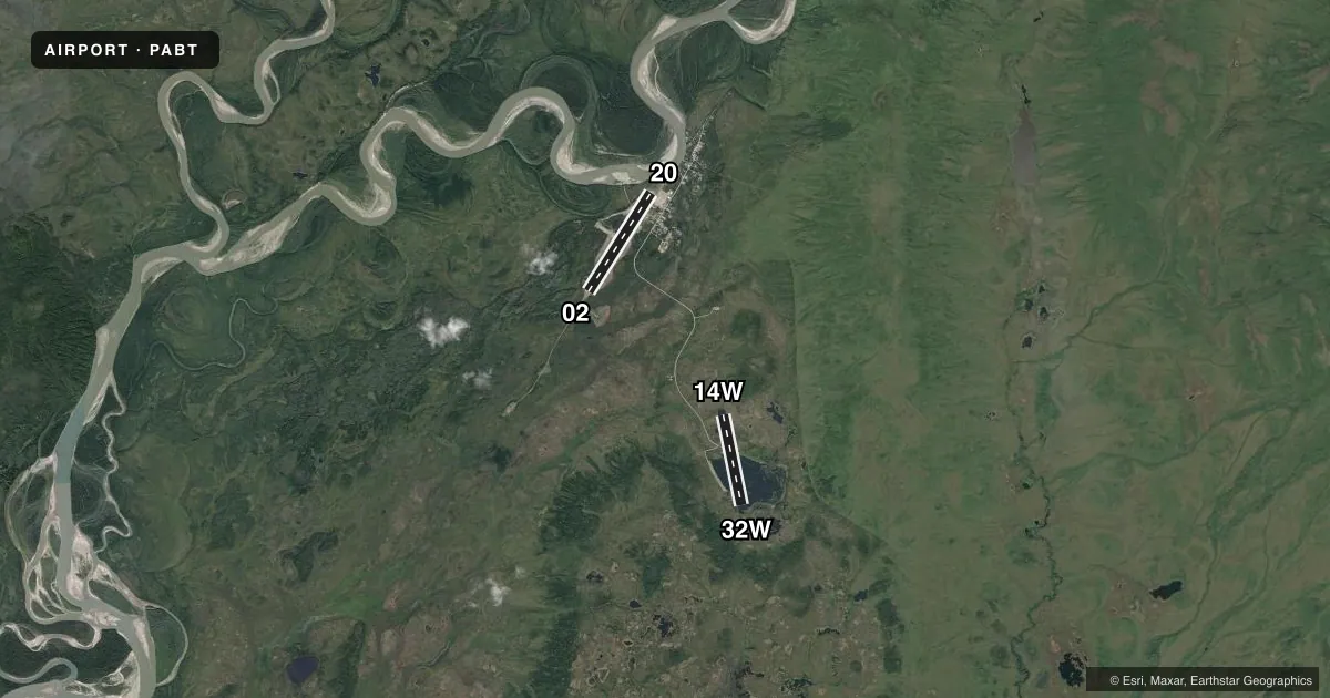
Runways & pattern
Full pagePattern entry · RWY 02
LEFT TRAFFIC| Runway | Heading (°M) | Length | Surface | Traffic |
|---|---|---|---|---|
| 02/20Favored | 16° / 196° | 5,190 ft | GRVL | Standard L |
| 14W/32W | 153° / 333° | 4,100 ft | WATER | Standard L |
Runway end performance
| End | TORA | TODA | ASDA | LDA | VGSI | Approach lights | Obstruction |
|---|---|---|---|---|---|---|---|
| 02 | — | — | — | — | VASI 4-box left(3°) | MALS | 15', road, 0' from thr, 80' R of cntrln, slope 0 |
| 20 | — | — | — | — | VASI 4-box left(3°) | — | 15', road, 0' from thr, 80' R of cntrln, slope 0 |
Declared distances in feet. TORA = takeoff run available, TODA = takeoff distance, ASDA = accelerate-stop, LDA = landing distance.
Airport sketch
Runways drawn to scale from FAA survey coordinates, rendered over satellite imagery. Not for navigation.
Approaches & charts
Services on the field
Fuel grades, oxygen, maintenance, ramp storage and lighting — as declared to the FAA by the airport operator.
Fuel & services
- Fuel
- 100LLA1+
Ramp & ground
- Transient storage
- Tie-down
- Lighting schedule
- SEE RMK
- Beacon schedule
- SEE RMK
- Beacon
- White / Green (civil land)(WG)
- Wind indicator
- Lighted
- Segmented circle
- Yes
Fuel & FBOs
Cheapest 100LL and Jet A on the field and nearby. Always confirm with the FBO before taxi.
Airport notes
Surface conditions, obstructions, local procedures, lighting outages and other notes published with each FAA cycle.
General notes
- WINTER SNOW REMOVAL - CTAF.
- WX OBS AVBL - BETTLES WX ON CTAF OR 907-692-5533.
- RWY COND UNMNT; RCMD VISUAL INSP PRIOR TO LNDG.
- WX CAMERA AVBL ON INTERNET AT HTTPS://WEATHERCAMS.FAA.GOV
- COLD TEMPERATURE AIRPORT. ALTITUDE CORRECTION REQUIRED AT OR BELOW -44C.
- FLOAT PLANE OPS 2 MI SE.
- FUEL H24; UNLEADED AVBL - 121.7/130.1/907-692-5111/907-692-5444.
Lighting notes
- ACTVT SR-SS - CTAF.
- ACTVT MALS RWY 02; VASI RWY 02 & 20; MIRL RWY 02/20 - CTAF.
VFR map & nearby airports
VFR sectional. Tap any ICAO chip to open that airport.
Key facts · PABT
Answer card- ICAO
- PABT
- Name
- BETTLES
- Location
- BETTLES, ALASKA
- Elevation
- 647.3 ft MSL
- Traffic pattern altitude
- 1,647.3 ft MSL (1,000 AGL)
- Control tower
- Non-towered (use CTAF)
- Total runways
- 2
- Longest runway
- 02/20 · 5,190 ft
- Published ILS approaches
- 0
- Published frequencies
- 1
- Magnetic variation
- 16°
- Current flight rules
- VFR
- Current wind
- 010° at 3 kt
- Favored runway now
- RWY 02
Bettles Airport sits in Bettles, Alaska. Field elevation is 647.3 ft MSL. The airport has two runways. The longest is runway 02/20 at 5,190 ft on gravel. There is also runway 14W/32W, a 4,100 ft water runway. This is a non-towered field. CTAF is 122.9.
No ILS approaches are published here. Pattern altitude is not published. Use the standard 1,000 ft AGL for light piston aircraft unless the current Chart Supplement says otherwise. Bettles Lodge is on the field. It carries 100LL, Jet A and mogas. Fuel is listed as available 24 hours. The published remarks also note that the beacon runs from sunset to sunrise and is controlled on CTAF. Runway lights on 02 and 20 are medium intensity and also CTAF-controlled. VASI is available on 02 and 20. The MALSR is activated on runway 02.
A first-time pilot should pay attention to the cold-weather notes. This is a cold temperature airport. Altitude correction is required at or below minus 44 degrees Celsius. Runway condition is unmonitored. A visual inspection before landing is recommended. Winter snow removal is coordinated on CTAF. Weather observations are available on CTAF or by phone. Float plane operations occur 2 miles southeast. Check the current Chart Supplement before departure for any updates to lighting, runway condition, or local procedures.