METAR & TAF PFAL
PFAL does not publish a METAR.
Showing the nearest reporting station: PABT (BETTLES) · 33.8 NM away. Conditions at PFAL may differ.
METAR · PABT
Observed 08:53Z
PABT 270853Z 00000KT 10SM FEW090 FEW130 16/12 A2972 RMK SLP068 FU DSNT N AND DSNT E T01610117 402610117 53005
- Wind
- 000° @ 0 kt
- Visibility
- 10 SM
- Temp / Dew
- 16°C / 12°C
- Altimeter
- 29.72 inHg
- Clouds
- FEW
- Density alt
- 915 ft
- Ceiling
- Unlimited
- Rules
- VFR
Airport info & contacts
Manager on record, flight service, ARTCC, attendance schedule and pattern altitude — published by the FAA and refreshed every 28 days.
Location
- From city
- 1 NM SSE
- VFR sectional
- FAIRBANKS
- ARTCC
- ZAN · ANCHORAGE
- NOTAM facility
- FAI (NOTAM-D)
Airport manager
- Name
- JASON LUDINGTON
- Phone
- (907) 451-5280
- Address
- 2301 PEGER ROAD, FAIRBANKS AK 99709
Flight service · Hours
- FSS FAI
- FAIRBANKS907-474-07881-866-248-6516
- Attendance
- Unattended
Frequencies
Tap any row to copy the frequency to your clipboard.
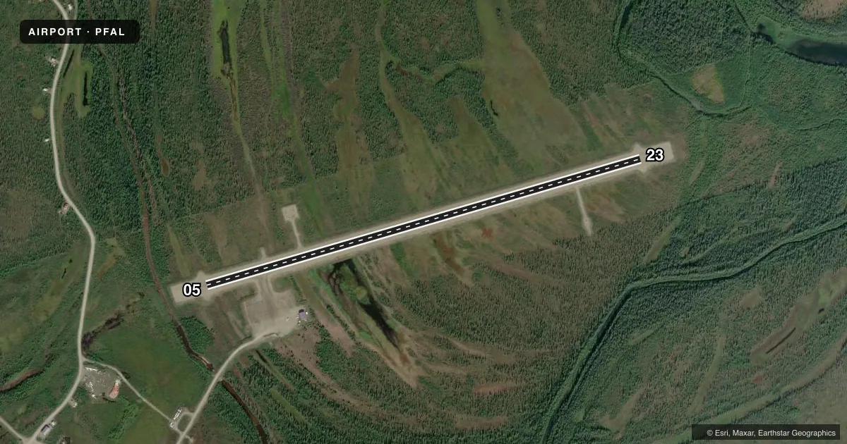
Runways & pattern
Full pagePattern entry · RWY 05
LEFT TRAFFICRunway end performance
| End | TORA | TODA | ASDA | LDA | VGSI | Approach lights | Obstruction |
|---|---|---|---|---|---|---|---|
| 05 | — | — | — | — | — | — | 9', brush, 336' from thr, slope 37 |
Declared distances in feet. TORA = takeoff run available, TODA = takeoff distance, ASDA = accelerate-stop, LDA = landing distance.
Airport sketch
Runways drawn to scale from FAA survey coordinates, rendered over satellite imagery. Not for navigation.
Approaches & charts
Services on the field
Fuel grades, oxygen, maintenance, ramp storage and lighting — as declared to the FAA by the airport operator.
Fuel & services
- Fuel
- Not available
Ramp & ground
- Transient storage
- Tie-down
- Lighting schedule
- SEE RMK
- Beacon schedule
- SS-SR
- Beacon
- White / Green (civil land)(WG)
- Wind indicator
- Lighted
- Segmented circle
- Yes
Fuel & FBOs
Cheapest 100LL and Jet A on the field and nearby. Always confirm with the FBO before taxi.
Airport notes
Surface conditions, obstructions, local procedures, lighting outages and other notes published with each FAA cycle.
General notes
- SNOW REMOVAL OPNS DURING WINTER - MONITOR CTAF.
- RY COND NOT MONITORED, RECOMMEND VISUAL INSPECTION. PRIOR TO LANDING.
- ROTATING BEACON MAY NOT BE OBSERVED FROM NORTHERN QUADRANTS AT LOW ALTITUDES
- WX CAMERA AVBL ON INTERNET AT HTTPS://WEATHERCAMS.FAA.GOV
- COLD TEMPERATURE AIRPORT. ALTITUDE CORRECTION REQUIRED AT OR BELOW -43C.
Lighting notes
- ACTVT MIRL RY 05/23 - CTAF.
Approach & departure obstructions
- 05RY 05/23 MARKED WITH LIGHTS AND CONES.
Other notes
- PRVDD A CLEAR ENVIRONMENTAL REVIEW.
VFR map & nearby airports
VFR sectional. Tap any ICAO chip to open that airport.
Key facts · PFAL
Answer card- ICAO
- PFAL
- Name
- ALLAKAKET
- Location
- ALLAKAKET, ALASKA
- Elevation
- 441.1 ft MSL
- Traffic pattern altitude
- 1,441.1 ft MSL (1,000 AGL)
- Control tower
- Non-towered (use CTAF)
- Total runways
- 1
- Longest runway
- 05/23 · 4,000 ft
- Published ILS approaches
- 0
- Published frequencies
- 1
- Magnetic variation
- 22°
- Current flight rules
- VFR
- Current wind
- 000° at 0 kt
- Favored runway now
- –
Allakaket Airport sits in Allakaket, Alaska. Field elevation is 441.1 ft MSL. The airport has one runway. Runway 05/23 is 4,000 ft long and gravel. No tower is published, so traffic calls go on CTAF 122.9. No ILS approaches are published.
Pattern altitude is not published. Use the standard 1,000 ft AGL unless the current Chart Supplement says otherwise. That puts the light-piston pattern at about 1,441 ft MSL based on the listed field elevation. The published remarks matter here. The rotating beacon may be hard to see from the north at low altitude. Runway condition is not monitored, so a visual check before landing is smart. Winter snow removal also happens here. Monitor CTAF for airport activity.
The field has medium intensity runway lights on 05/23 that are activated by CTAF. Runway 05/23 is also marked with lights and cones. This is a cold temperature airport. Altitude correction is required at or below minus 43 degrees Celsius. No on-field FBOs are listed, so verify services with the airport operator or call the field directly before you go.