METAR & TAF PAHU
PAHU does not publish a METAR.
Showing the nearest reporting station: PAHL (HUSLIA) · 55.2 NM away. Conditions at PAHU may differ.
METAR · PAHL
Observed 02:56Z
PAHL 280256Z AUTO 17010G18KT 9SM RA OVC065 18/13 A2973 RMK AO2 PK WND 12027/0220 RAB51 SLP067 P0000 60000 T01830133 53002 TSNO
- Wind
- 170° @ 10G18 kt
- Visibility
- 9 SM
- Temp / Dew
- 18°C / 13°C
- Altimeter
- 29.73 inHg
- Clouds
- OVC
- Density alt
- 966 ft
- Ceiling
- 6,500 ft AGL
- Rules
- VFR
Airport info & contacts
Manager on record, flight service, ARTCC, attendance schedule and pattern altitude — published by the FAA and refreshed every 28 days.
Location
- From city
- 1 NM SW
- VFR sectional
- FAIRBANKS
- ARTCC
- ZAN · ANCHORAGE
- NOTAM facility
- FAI (NOTAM-D)
Airport manager
- Name
- JASON LUDINGTON
- Phone
- (907) 451-5280
- Address
- 2301 PEGER RD, FAIRBANKS AK 99709
Flight service · Hours
- FSS FAI
- FAIRBANKS907-474-07881-866-248-6516
- Attendance
- Unattended
Frequencies
Tap any row to copy the frequency to your clipboard.
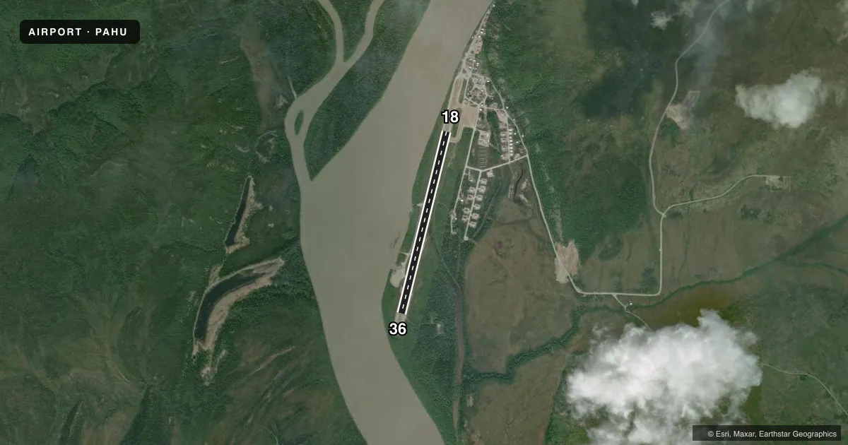
Runways & pattern
Full pagePattern entry · RWY 18
LEFT TRAFFICRunway end performance
| End | TORA | TODA | ASDA | LDA | VGSI | Approach lights | Obstruction |
|---|---|---|---|---|---|---|---|
| 18 | — | — | — | — | — | — | 15', trees, 0' from thr, 108' R of cntrln, slope 0 |
| 36 | — | — | — | — | — | — | 15', trees, 0' from thr, 105' R of cntrln, slope 0 |
Declared distances in feet. TORA = takeoff run available, TODA = takeoff distance, ASDA = accelerate-stop, LDA = landing distance.
Airport sketch
Runways drawn to scale from FAA survey coordinates, rendered over satellite imagery. Not for navigation.
Approaches & charts
Services on the field
Fuel grades, oxygen, maintenance, ramp storage and lighting — as declared to the FAA by the airport operator.
Fuel & services
- Fuel
- Not available
- Oxygen (bottled)
- Not available
- Oxygen (bulk)
- Not available
- Airframe repair
- Not available
- Power plant repair
- Not available
Ramp & ground
- Transient storage
- Not published
- Landing fee
- No fee published
- Customs
- Not available
- Lighting schedule
- SEE RMK
- Beacon schedule
- SEE RMK
- Beacon
- White / Green (civil land)(WG)
- Wind indicator
- Lighted
- Segmented circle
- Yes
Fuel & FBOs
Cheapest 100LL and Jet A on the field and nearby. Always confirm with the FBO before taxi.
Airport notes
Surface conditions, obstructions, local procedures, lighting outages and other notes published with each FAA cycle.
General notes
- RWY CONDITION NOT MONITORED; RECOMMEND VISUAL INSPECTION PRIOR TO LANDING.
- SNOW REMOVAL OPERATIONS DURING WINTER - MONITOR CTAF.
- SOUTH SAFETY AREA SOFT & RUTTED.
- TWY A UNLIT.
- TWY A REFLECTORS 36 INCHES TALL.
- 150 FT X 100 FT TURN AROUND NORTH SIDE OF RWY.
Lighting notes
- ACTVT ROTATING BEACON - CTAF.
- ACTVT MIRL RWY 18/36 - CTAF.
VFR map & nearby airports
VFR sectional. Tap any ICAO chip to open that airport.
Key facts · PAHU
Answer card- ICAO
- PAHU
- Name
- HUGHES
- Location
- HUGHES, ALASKA
- Elevation
- 298.6 ft MSL
- Traffic pattern altitude
- 1,298.6 ft MSL (1,000 AGL)
- Control tower
- Non-towered (use CTAF)
- Total runways
- 1
- Longest runway
- 18/36 · 3,381 ft
- Published ILS approaches
- 0
- Published frequencies
- 1
- Magnetic variation
- 13°
- Current flight rules
- VFR
- Current wind
- 170° at 10 kt
- Favored runway now
- RWY 18
PAHU is the airport at Hughes, Alaska. Field elevation is 298.6 ft MSL. The field has one runway. Runway 18/36 is 3,381 ft long and gravel. There is no control tower, so self-announce on CTAF 122.9 and keep a close scan for traffic. No ILS approaches are published here.
Pattern altitude is not published for this field. Use the standard 1,000 ft AGL for light piston operations unless current local guidance says otherwise. The published remarks matter here. Taxiway A is unlit. The runway lights on 18/36 are medium intensity and are activated by CTAF. The rotating beacon is also CTAF-activated. Winter snow removal happens here, so monitor the CTAF if you are inbound in cold weather. The runway condition is not monitored. A visual inspection before landing is recommended.
There are no on-field FBOs listed, so plan on verifying services with the airport operator or the FBO directly by phone before arrival. The south safety area is soft and rutted. There is also a 150 foot by 100 foot turnaround on the north side of the runway. For a first visit, treat this as a basic Alaska gravel strip with limited published approach support. Check the current Chart Supplement for any updates before you go.