METAR & TAF PARY
Current METAR
Observed 01:56Z
PARY 280156Z AUTO 00000KT 10SM -RA OVC070 13/12 A2978
- Wind
- 000° @ 0 kt
- Visibility
- 10 SM
- Temp / Dew
- 13°C / 12°C
- Altimeter
- 29.78 inHg
- Clouds
- OVC
- Density alt
- 749 ft
- Ceiling
- 7,000 ft AGL
- Rules
- VFR
Airport info & contacts
Manager on record, flight service, ARTCC, attendance schedule and pattern altitude — published by the FAA and refreshed every 28 days.
Location
- From city
- 1 NM SE
- VFR sectional
- FAIRBANKS
- ARTCC
- ZAN · ANCHORAGE
- NOTAM facility
- RBY (NOTAM-D)
Airport manager
- Name
- JASON LUDINGTON
- Phone
- (907) 451-5280
- Address
- 2301 PEGER RD, FAIRBANKS AK 99709
Flight service · Hours
- FSS FAI
- FAIRBANKS907-474-07881-866-248-6516
- Attendance
- Unattended
Frequencies
Tap any row to copy the frequency to your clipboard.
Runways & pattern
Full pagePattern entry · RWY 03
LEFT TRAFFICRunway end performance
| End | TORA | TODA | ASDA | LDA | VGSI | Approach lights | Obstruction |
|---|---|---|---|---|---|---|---|
| 03 | — | — | — | — | — | — | 19', trees, 0' from thr, 166' R of cntrln, slope 0 |
| 21 | — | — | — | — | PAPI 4-box left(3°) | — | 10', brush, 0' from thr, 150' R of cntrln, slope 0 |
Declared distances in feet. TORA = takeoff run available, TODA = takeoff distance, ASDA = accelerate-stop, LDA = landing distance.
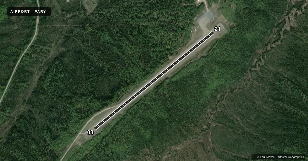
Airport sketch
Runways drawn to scale from FAA survey coordinates, rendered over satellite imagery. Not for navigation.
Approaches & charts
Services on the field
Fuel grades, oxygen, maintenance, ramp storage and lighting — as declared to the FAA by the airport operator.
Fuel & services
- Fuel
- Not available
Ramp & ground
- Transient storage
- Tie-down
- Landing fee
- No fee published
- Customs
- Not available
- Lighting schedule
- SEE RMK
- Beacon schedule
- SEE RMK
- Beacon
- White / Green (civil land)(WG)
- Wind indicator
- Lighted
- Segmented circle
- Yes
Fuel & FBOs
Cheapest 100LL and Jet A on the field and nearby. Always confirm with the FBO before taxi.
Airport notes
Surface conditions, obstructions, local procedures, lighting outages and other notes published with each FAA cycle.
General notes
- RWY COND UNMN; RCMND VISUAL INSP BFR LNDG.
- WX CAMERA AVBL ON INTERNET AT HTTPS://WEATHERCAMS.FAA.GOV
- COLD TEMPERATURE AIRPORT. ALTITUDE CORRECTION REQUIRED AT OR BELOW -39C.
- BIRDS INVOF LANDFILL 1 MI SW OF RWY.
Lighting notes
- ACTVT ROTG BCN - CTAF.
- ACTVT REIL RWY 21; PAPI RWY 21; MIRL RWY 03/21 - CTAF.
Approach & departure obstructions
- 21DOWN SLOPE 2 PCT GRADE.
Other notes
- ESTABD PRIOR TO 1959.
- WINTER RECEPTACLES AVBL NEAR TIE-DOWN.
- 03/21DOWN SLOPE TO MID.
VFR map & nearby airports
VFR sectional. Tap any ICAO chip to open that airport.
Key facts · PARY
Answer card- ICAO
- PARY
- Name
- RUBY
- Location
- RUBY, ALASKA
- Elevation
- 657.5 ft MSL
- Traffic pattern altitude
- 1,657.5 ft MSL (1,000 AGL)
- Control tower
- Non-towered (use CTAF)
- Total runways
- 1
- Longest runway
- 03/21 · 4,000 ft
- Published ILS approaches
- 0
- Published frequencies
- 1
- Magnetic variation
- 20°
- Current flight rules
- VFR
- Current wind
- 000° at 0 kt
- Favored runway now
- –
Ruby Airport is in Ruby, Alaska. The field elevation is 657.5 ft MSL. It has one runway. Runway 03/21 is 4,000 ft long and gravel. The airport is not towered, so CTAF self-announce work is the normal flow here. CTAF is 122.8. No ILS approaches are published.
Pattern altitude is not published. Use the standard 1,000 ft AGL pattern for light piston aircraft unless local conditions or the current Chart Supplement say otherwise. The runway lighting is CTAF-activated. Runway 21 has REIL and PAPI lighting. The rotating beacon is also activated by the CTAF. Published remarks say runway condition is unmonitored, so a visual check before landing is smart. Runway 03/21 has a downslope to the midpoint. Runway 21 has a 2 percent downslope. This is a cold temperature airport too. Altitude correction is required at or below minus 39 degrees Celsius. Birds are reported near a landfill one mile southwest of the runway. There are no on-field FBOs listed, so verify services with the airport operator or the FBO directly by phone before you go.