METAR & TAF PAHL
Current METAR
Observed 05:56Z
PAHL 280556Z AUTO 25005KT 10SM SCT060 OVC110 16/14 A2973 RMK AO2 RAB11E45 SLP069 P0004 60010 T01560139 10261 20150 50001 TSNO
- Wind
- 250° @ 5 kt
- Visibility
- 10 SM
- Temp / Dew
- 16°C / 14°C
- Altimeter
- 29.73 inHg
- Clouds
- OVC
- Density alt
- 628 ft
- Ceiling
- 11,000 ft AGL
- Rules
- VFR
Airport info & contacts
Manager on record, flight service, ARTCC, attendance schedule and pattern altitude — published by the FAA and refreshed every 28 days.
Location
- From city
- 1 NM E
- VFR sectional
- FAIRBANKS
- ARTCC
- ZAN · ANCHORAGE
- NOTAM facility
- HLA (NOTAM-D)
Airport manager
- Name
- JASON LUDINGTON
- Phone
- (907) 451-5280
- Address
- 2301 PEGER RD, FAIRBANKS AK 99709-5399
Flight service · Hours
- FSS FAI
- FAIRBANKS907-474-07881-866-248-6516
- Attendance
- Unattended
Frequencies
Tap any row to copy the frequency to your clipboard.
Runways & pattern
Full pagePattern entry · RWY 21
LEFT TRAFFICRunway end performance
| End | TORA | TODA | ASDA | LDA | VGSI | Approach lights | Obstruction |
|---|---|---|---|---|---|---|---|
| 03 | — | — | — | — | PAPI 4-box left(3°) | — | 14', tree, 0' from thr, 187' R of cntrln, slope 0 |
| 21 | — | — | — | — | PAPI 4-box left(3°) | — | 10', trees, 0' from thr, 145' R of cntrln, slope 0 |
Declared distances in feet. TORA = takeoff run available, TODA = takeoff distance, ASDA = accelerate-stop, LDA = landing distance.
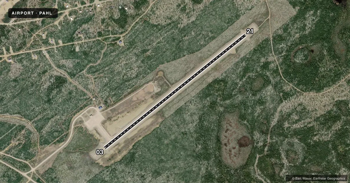
Airport sketch
Runways drawn to scale from FAA survey coordinates, rendered over satellite imagery. Not for navigation.
Approaches & charts
Services on the field
Fuel grades, oxygen, maintenance, ramp storage and lighting — as declared to the FAA by the airport operator.
Fuel & services
- Fuel
- Not available
Ramp & ground
- Transient storage
- Tie-down
- Lighting schedule
- SEE RMK
- Beacon schedule
- SS-SR
- Beacon
- White / Green (civil land)(WG)
- Wind indicator
- Lighted
- Segmented circle
- Yes
Fuel & FBOs
Cheapest 100LL and Jet A on the field and nearby. Always confirm with the FBO before taxi.
Airport notes
Surface conditions, obstructions, local procedures, lighting outages and other notes published with each FAA cycle.
General notes
- RY CONDITION UNMONITORED; RECOMMEND VISUAL INSPECTION PRIOR TO LDG.
- SNOW REMOVAL OPNS DURG WINTER. MONITOR CTAF.
- WX CAMERA AVBL ON INTERNET AT HTTPS://WEATHERCAMS.FAA.GOV
Lighting notes
- ACTVT MIRL RY 03/21; PAPI & REIL RYS 03 & 21 - CTAF.
Other notes
- PRVDD ARPT DEVELOPMENT PROPOSED ON ALP & REQUIRING ENVIRONMENTAL PROCESSING BE UNDERTAKEN W/O PRIOR WRITTEN APPROVAL FM FAA.
- 03/21RY SOFT WHEN WET.
VFR map & nearby airports
VFR sectional. Tap any ICAO chip to open that airport.
Key facts · PAHL
Answer card- ICAO
- PAHL
- Name
- HUSLIA
- Location
- HUSLIA, ALASKA
- Elevation
- 219.7 ft MSL
- Traffic pattern altitude
- 1,219.7 ft MSL (1,000 AGL)
- Control tower
- Non-towered (use CTAF)
- Total runways
- 1
- Longest runway
- 03/21 · 4,000 ft
- Published ILS approaches
- 0
- Published frequencies
- 2
- Magnetic variation
- 19°
- Current flight rules
- VFR
- Current wind
- 250° at 5 kt
- Favored runway now
- RWY 21
Huslia Airport (PAHL) sits in Huslia, Alaska. Field elevation is 219.7 ft MSL. The airport has one runway. Runway 03/21 is 4,000 ft long and gravel. The runway headings are 51° and 231° magnetic. No control tower is published, so use CTAF 122.8 for local traffic. No ILS approaches are published here.
Pattern altitude is not published. Use 1,000 ft AGL for light piston operations unless the current FAA Chart Supplement says otherwise. That puts the standard pattern at about 1,220 ft MSL based on the field elevation. Check the current Chart Supplement before you go if you need the published pattern or any local procedure.
The published remarks matter here. Runway condition is unmonitored, so plan a visual inspection before landing. The runway can be soft when wet. Snow removal happens in winter, so listen on 122.8 for traffic and field updates. Medium intensity runway lights are available on 03/21. PAPI and REIL are published for both runway ends and are activated by CTAF. No on-field FBOs are listed, so contact the airport operator or the FBO directly by phone for current services and fuel availability before arrival.