METAR & TAF PFKU
PFKU does not publish a METAR.
Showing the nearest reporting station: PANU (NULATO) · 12.4 NM away. Conditions at PFKU may differ.
METAR · PANU
Observed 05:56Z
PANU 280556Z AUTO 23004KT 10SM -RA FEW002 BKN080 OVC095 14/13 A2982 RMK AO2 RAB32 SLP008 P0001 60005 T01390133 10206 20133 50004
- Wind
- 230° @ 4 kt
- Visibility
- 10 SM
- Temp / Dew
- 14°C / 13°C
- Altimeter
- 29.82 inHg
- Clouds
- OVC
- Density alt
- 189 ft
- Ceiling
- 8,000 ft AGL
- Rules
- VFR
Airport info & contacts
Manager on record, flight service, ARTCC, attendance schedule and pattern altitude — published by the FAA and refreshed every 28 days.
Location
- From city
- 0 NM W
- VFR sectional
- FAIRBANKS
- ARTCC
- ZAN · ANCHORAGE
- NOTAM facility
- FAI (NOTAM-D)
Airport manager
- Name
- JASON LUNDINGTON
- Phone
- (907) 451-5280
- Address
- 2301 PEGER RD, FAIRBANKS AK 99709
Flight service · Hours
- FSS FAI
- FAIRBANKS907-474-07881-866-248-6516
- Attendance
- Unattended
Frequencies
Tap any row to copy the frequency to your clipboard.
Runways & pattern
Full pagePattern entry · RWY 25
LEFT TRAFFICRunway end performance
| End | TORA | TODA | ASDA | LDA | VGSI | Approach lights | Obstruction |
|---|---|---|---|---|---|---|---|
| 07 | — | — | — | — | PAPI 4-box left(4°) | — | 30', trees, 0' from thr, 130' R of cntrln, slope 0 |
| 25 | — | — | — | — | — | — | 24', trees, 0' from thr, 170' R of cntrln, slope 0 |
Declared distances in feet. TORA = takeoff run available, TODA = takeoff distance, ASDA = accelerate-stop, LDA = landing distance.
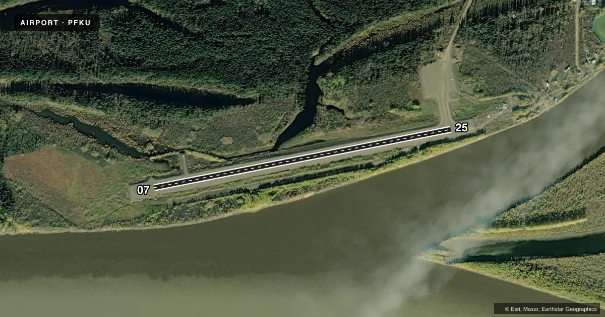
Airport sketch
Runways drawn to scale from FAA survey coordinates, rendered over satellite imagery. Not for navigation.
Approaches & charts
Services on the field
Fuel grades, oxygen, maintenance, ramp storage and lighting — as declared to the FAA by the airport operator.
Fuel & services
- Fuel
- Not available
Ramp & ground
- Transient storage
- Not published
- Landing fee
- No fee published
- Customs
- Not available
- Lighting schedule
- SEE RMK
- Beacon schedule
- SEE RMK
- Beacon
- White / Green (civil land)(WG)
- Wind indicator
- Lighted
- Segmented circle
- Yes
Fuel & FBOs
Cheapest 100LL and Jet A on the field and nearby. Always confirm with the FBO before taxi.
Airport notes
Surface conditions, obstructions, local procedures, lighting outages and other notes published with each FAA cycle.
General notes
- SNOW REMOVAL OPS MNT CTAF.
- RWY COND UNMNT; RCMND VISUAL INSP PRIOR TO LNDG.
- COLD TEMPERATURE AIRPORT. ALTITUDE CORRECTION REQUIRED AT OR BELOW -47C.
Lighting notes
- ACTVT ROTG BCN - CTAF.
- ACTVT PAPI RWY 07; REIL RWY 07; MIRL RWY 07/25 - CTAF.
Approach & departure obstructions
- 07PLASTIC MKRS.
- 25PLASTIC MKRS.
Other notes
- THIS AIRPORT HAS BEEN SURVEYED BY THE NATIONAL GEODETIC SURVEY.
- 07/25SOFT WHEN WET; RUTS & GRASS ENTIRE LEN.
VFR map & nearby airports
VFR sectional. Tap any ICAO chip to open that airport.
Key facts · PFKU
Answer card- ICAO
- PFKU
- Name
- KOYUKUK
- Location
- KOYUKUK, ALASKA
- Elevation
- 148.9 ft MSL
- Traffic pattern altitude
- 1,148.9 ft MSL (1,000 AGL)
- Control tower
- Non-towered (use CTAF)
- Total runways
- 1
- Longest runway
- 07/25 · 4,000 ft
- Published ILS approaches
- 0
- Published frequencies
- 1
- Magnetic variation
- 11°
- Current flight rules
- VFR
- Current wind
- 230° at 4 kt
- Favored runway now
- RWY 25
Koyukuk Airport sits in Koyukuk, Alaska. Field elevation is 148.9 ft MSL. The airport has one runway. Runway 07/25 is 4,000 ft of gravel, which is the longest runway on the field. There is no control tower. CTAF is 122.9.
No ILS approaches are published here. Pattern altitude is not published, so verify the current Chart Supplement before you fly. For a light piston, plan on the standard 1,000 ft AGL unless the current published data says otherwise. The airport has medium intensity runway lighting on 07 and 25. PAPI and REIL are available on runway 07. The rotating beacon is activated on the CTAF.
This is a cold temperature airport. Altitude correction is required at or below minus 47 degrees Celsius. Runway condition is unmonitored. A visual inspection before landing is recommended. The runway is reported soft when wet. It also has ruts and grass along the full length. Runway 07 and runway 25 have plastic markers. Snow removal operations monitor the CTAF. No on-field FBOs are listed, so contact the airport operator directly or call on CTAF for current service and fuel availability before arrival.