METAR & TAF Z17
Z17 does not publish a METAR.
Showing the nearest reporting station: PAMC (MC GRATH) · 27.6 NM away. Conditions at Z17 may differ.
METAR · PAMC
Observed 05:53Z
PAMC 280553Z AUTO 22008G15KT 10SM -RA SCT036 OVC060 12/10 A2992 RMK AO2 SLP135 P0002 60032 T01170100 10128 20117 51016 TSNO $
- Wind
- 220° @ 8G15 kt
- Visibility
- 10 SM
- Temp / Dew
- 12°C / 10°C
- Altimeter
- 29.92 inHg
- Clouds
- OVC
- Density alt
- 378 ft
- Ceiling
- 6,000 ft AGL
- Rules
- VFR
Airport info & contacts
Manager on record, flight service, ARTCC, attendance schedule and pattern altitude — published by the FAA and refreshed every 28 days.
Location
- From city
- 0 NM NW
- VFR sectional
- MC GRATH
- ARTCC
- ZAN · ANCHORAGE
- NOTAM facility
- ENA (NOTAM-D)
Airport manager
- Name
- STEFFEN STRICK
- Phone
- 907-524-3241
- Address
- PO BOX 21, MC GRATH AK 99627
Flight service · Hours
- FSS ENA
- KENAI907-283-72111-866-864-1737
- Attendance
- Unattended
Frequencies
Tap any row to copy the frequency to your clipboard.
Runways & pattern
Full pagePattern entry · RWY 11
LEFT TRAFFICRunway end performance
| End | TORA | TODA | ASDA | LDA | VGSI | Approach lights | Obstruction |
|---|---|---|---|---|---|---|---|
| 11 | — | — | — | — | — | — | 15', trees, 21' from thr, 0' R of cntrln, slope 1 |
| 29 | — | — | — | — | — | — | 23', trees, 0' from thr, 0' R of cntrln, slope 0 |
Declared distances in feet. TORA = takeoff run available, TODA = takeoff distance, ASDA = accelerate-stop, LDA = landing distance.
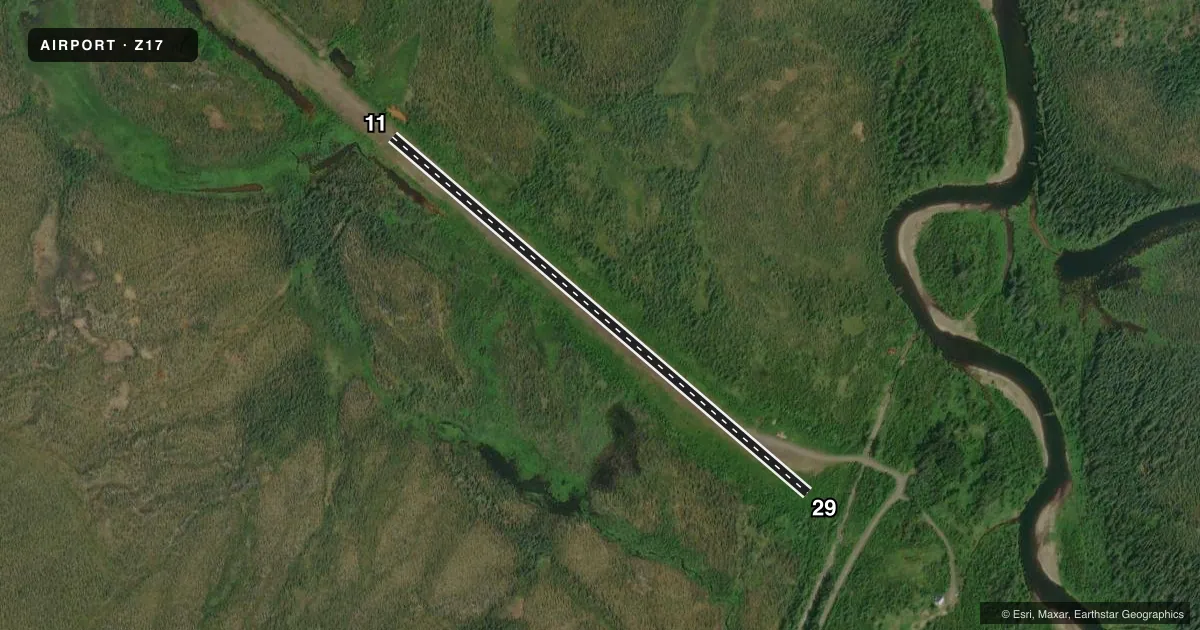
Airport sketch
Runways drawn to scale from FAA survey coordinates, rendered over satellite imagery. Not for navigation.
Approaches & charts
Services on the field
Fuel grades, oxygen, maintenance, ramp storage and lighting — as declared to the FAA by the airport operator.
Fuel & services
- Fuel
- Not available
- Oxygen (bottled)
- Not available
- Oxygen (bulk)
- Not available
- Airframe repair
- Not available
- Power plant repair
- Not available
Ramp & ground
- Transient storage
- Not published
- Landing fee
- No fee published
- Customs
- Not available
- Wind indicator
- No
- Segmented circle
- No
Fuel & FBOs
Cheapest 100LL and Jet A on the field and nearby. Always confirm with the FBO before taxi.
Airport notes
Surface conditions, obstructions, local procedures, lighting outages and other notes published with each FAA cycle.
General notes
- RY NOT MAINTAINED ON A REGULAR SCHEDULE; RCMD INSPECTION PRIOR TO USE.
Other notes
- ESTABD PRIOR TO 1959.
- WINDSOCK MISSING - WEST END.
- 11/29SHARP ROCKS 2 IN X 6 IN ON RWY SFC. RIDGES, RUTS, & EQUIP TRACKS ON RWY SFC, 2 IN X 4 IN DEEP. STANDING WATER ON RWY SFC AFTER RAIN. SAFETY AREAS ON RWY EDGES VERY ROUGH. WEST 500 FT OF RWY UNDER WATER DUE TO FLOODING.
- 11/29PUDDLES, TREES, & SHRUBS ON RWY. FIRST 300 FT OF WEST END FLOODED.
VFR map & nearby airports
VFR sectional. Tap any ICAO chip to open that airport.
Key facts · Z17
Answer card- ICAO
- Z17
- Name
- OPHIR
- Location
- OPHIR, ALASKA
- Elevation
- 595 ft MSL
- Traffic pattern altitude
- 1,595 ft MSL (1,000 AGL)
- Control tower
- Non-towered (use CTAF)
- Total runways
- 1
- Longest runway
- 11/29 · 1,940 ft
- Published ILS approaches
- 0
- Published frequencies
- 1
- Magnetic variation
- 22°
- Current flight rules
- VFR
- Current wind
- 220° at 8 kt
- Favored runway now
- RWY 11
Ophir Airport (Z17) sits in Ophir, Alaska. Field elevation is 595 ft MSL. The airport has one runway, 11/29, which is 1,940 ft long and surfaced with gravel and dirt. This is an untowered field. CTAF is 122.9. No ILS approaches are published.
The published pattern altitude is not listed. Use the standard 1,000 ft AGL for light piston operations unless the current Chart Supplement says otherwise. The runway headings are magnetic. Runway 11 is 131°. Runway 29 is 311°.
This field has no on-field FBOs listed. Plan fuel and services elsewhere. The published remarks matter here. The runway is not maintained on a regular schedule. An inspection before use is recommended. The west 500 ft of the runway is underwater due to flooding. The first 300 ft of the west end is also flooded. Sharp rocks, ridges, ruts, equipment tracks, puddles, trees and shrubs are all reported on the surface. The west-end windsock is missing. For a first-time arrival, treat this as a rough backcountry strip and verify current conditions with the airport operator before you go.